
| Memorials | : | 0 |
| Location | : | Wolfe Island, Frontenac County, Canada |
| Coordinate | : | 44.2094400, -76.2812100 |
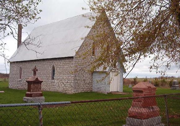
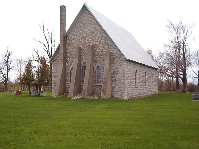
| Description | : | The Cemetery is in a fenced in Church yard still active. The Church has services in the summer months. It is located on Concession 16, lot 6. The land was bought from John Montgomery for 5 shillings by John Travers, The Lord Bishop Of Ontario. The Church was built in 1862 as a United Church of England and Ireland, later became known as Christ Church Anglican. The deed was reistered on May 31,1864 but it was not consecrated until February 20,1901. The first burial was William Montgomery in 1870. In July 1972 the cemetery was checked by Fern Small... Read More |
frequently asked questions (FAQ):
-
Where is Christ Church Anglican Cemetery?
Christ Church Anglican Cemetery is located at Concession XVI, Lot 6 Wolfe Island, Frontenac County ,Ontario ,Canada.
-
Christ Church Anglican Cemetery cemetery's updated grave count on graveviews.com?
0 memorials
-
Where are the coordinates of the Christ Church Anglican Cemetery?
Latitude: 44.2094400
Longitude: -76.2812100
Nearby Cemetories:
1. Saint Lawrence United Church Cemetery
Wolfe Island, Frontenac County, Canada
Coordinate: 44.2085080, -76.2400620
2. Dodge Bay Cemetery
Millen Bay, Jefferson County, USA
Coordinate: 44.1824100, -76.2273200
3. Sand Bay Cemetery
Cape Vincent, Jefferson County, USA
Coordinate: 44.1921997, -76.2078018
4. Saint Philomena's Cemetery
Howe Island, Frontenac County, Canada
Coordinate: 44.2672000, -76.2532200
5. Judd Cemetery
Jefferson County, USA
Coordinate: 44.1492004, -76.2964020
6. Riverside Cemetery
Cape Vincent, Jefferson County, USA
Coordinate: 44.1375008, -76.3097000
7. Eves Family Plot
Frontenac Islands, Frontenac County, Canada
Coordinate: 44.1891900, -76.3854100
8. New Saint Vincent de Paul Cemetery
Cape Vincent, Jefferson County, USA
Coordinate: 44.1342010, -76.3143997
9. Saint Lawrence Union Cemetery
Cape Vincent, Jefferson County, USA
Coordinate: 44.1589012, -76.1952972
10. Saint Vincent de Paul Cemetery
Rosiere, Jefferson County, USA
Coordinate: 44.1223760, -76.2419410
11. Saint Johns Episcopal Church Cemetery
Cape Vincent, Jefferson County, USA
Coordinate: 44.1248100, -76.3351100
12. Milton Cemetery
King Pitt, Frontenac County, Canada
Coordinate: 44.2512240, -76.3984110
13. Saint Vincent de Paul Catholic Church Cemetery
Cape Vincent, Jefferson County, USA
Coordinate: 44.1244400, -76.3391980
14. Market Street Cemetery
Cape Vincent, Jefferson County, USA
Coordinate: 44.1222200, -76.3352900
15. Old Saint Vincent de Paul Cemetery
Rosiere, Jefferson County, USA
Coordinate: 44.1094017, -76.2572021
16. Wolfe Island United Church Cemetery
Wolfe Island, Frontenac County, Canada
Coordinate: 44.1345100, -76.3769600
17. Sacred Heart New Roman Catholic Cemetery
Wolfe Island, Frontenac County, Canada
Coordinate: 44.1889100, -76.4403400
18. Trinity Anglican Cemetery
Wolfe Island, Frontenac County, Canada
Coordinate: 44.1913590, -76.4446340
19. Old Sacred Heart Cemetery
Wolfe Island, Frontenac County, Canada
Coordinate: 44.1893610, -76.4461650
20. Grindstone Island Cemetery
Clayton, Jefferson County, USA
Coordinate: 44.2808200, -76.1454000
21. Willowbank Cemetery
Gananoque, Leeds and Grenville United Counties, Canada
Coordinate: 44.3246994, -76.2173996
22. Harris Cemetery
Chaumont, Jefferson County, USA
Coordinate: 44.1156006, -76.1539001
23. Harder Cemetery
Jefferson County, USA
Coordinate: 44.0943985, -76.1911011
24. Three Mile Creek Cemetery
Clayton, Jefferson County, USA
Coordinate: 44.1533012, -76.1085968