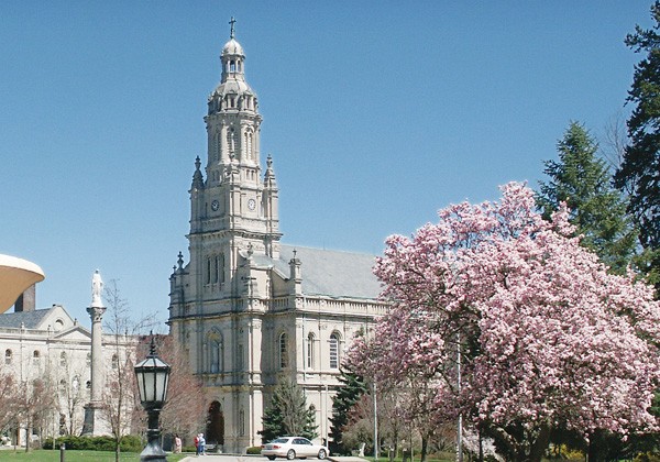
| Memorials | : | 0 |
| Location | : | Saint Mary-of-the-Woods, Vigo County, USA |
| Coordinate | : | 39.5096030, -87.4601840 |
| Description | : | From Terre Haute At Vigo County Courthouse, turn west onto U.S. 40. Cross bridge and proceed to first stoplight in West Terre Haute, the intersection of U.S. 40 and U.S. 150. Turn right on U.S. 150. Proceed approximately 2 miles to St. Mary's Road and sign for Saint Mary-of-the-Woods College. Turn left on St. Mary's Road. Proceed to main entrance (second gate). Turn right and proceed to end of the Avenue, go right at fountain. The roadway opens out into Providence Center And The Church of the Immaculate Conception. |
frequently asked questions (FAQ):
-
Where is Church of the Immaculate Conception?
Church of the Immaculate Conception is located at Saint Mary-of-the-Woods, Vigo County ,Indiana ,USA.
-
Church of the Immaculate Conception cemetery's updated grave count on graveviews.com?
0 memorials
-
Where are the coordinates of the Church of the Immaculate Conception?
Latitude: 39.5096030
Longitude: -87.4601840
Nearby Cemetories:
1. Providence Community Cemetery
Saint Mary-of-the-Woods, Vigo County, USA
Coordinate: 39.5093200, -87.4576100
2. Sisters of Providence Cemetery
Saint Mary-of-the-Woods, Vigo County, USA
Coordinate: 39.5094830, -87.4566440
3. Saint Marys Village Church Cemetery
Saint Mary-of-the-Woods, Vigo County, USA
Coordinate: 39.5127300, -87.4696100
4. Bethel Cemetery
Saint Mary-of-the-Woods, Vigo County, USA
Coordinate: 39.5203438, -87.4653320
5. Barnhart Cemetery
West Terre Haute, Vigo County, USA
Coordinate: 39.5000700, -87.4382500
6. Fort Harrison Cemetery
Terre Haute, Vigo County, USA
Coordinate: 39.5084200, -87.4125370
7. Coal Creek Cemetery
Vigo County, USA
Coordinate: 39.5353250, -87.4246580
8. New Vermillion Cemetery
Sandford, Vigo County, USA
Coordinate: 39.5414009, -87.4871979
9. Bethesda Cemetery
Sugar Creek Township, Vigo County, USA
Coordinate: 39.4732600, -87.4837980
10. Saint Joseph Cemetery
Terre Haute, Vigo County, USA
Coordinate: 39.4831100, -87.4162600
11. Pisgah Cemetery
Sandford, Vigo County, USA
Coordinate: 39.5171790, -87.5178380
12. Woodlawn Cemetery
Terre Haute, Vigo County, USA
Coordinate: 39.4815870, -87.4142000
13. Bennett Cemetery
Sugar Creek Township, Vigo County, USA
Coordinate: 39.4627800, -87.4604600
14. Indian Orchard Cemetery
Terre Haute, Vigo County, USA
Coordinate: 39.4726257, -87.4189148
15. Hay Cemetery
Tecumseh, Vigo County, USA
Coordinate: 39.5541250, -87.4319730
16. Pleasantview Cemetery
Tecumseh, Vigo County, USA
Coordinate: 39.5611000, -87.4255981
17. David Smith Cemetery
State Line, Vigo County, USA
Coordinate: 39.4762878, -87.5220261
18. Carson Cemetery
Sandford, Vigo County, USA
Coordinate: 39.5599022, -87.5004044
19. Haymaker Cemetery
New Goshen, Vigo County, USA
Coordinate: 39.5658000, -87.4890700
20. Barbour Cemetery
New Goshen, Vigo County, USA
Coordinate: 39.5710983, -87.4507980
21. Rose Hill Cemetery
New Goshen, Vigo County, USA
Coordinate: 39.5599403, -87.5091171
22. New Providence Cemetery
Paris, Edgar County, USA
Coordinate: 39.5013480, -87.5479550
23. Vigo County Historical Society Museum
Terre Haute, Vigo County, USA
Coordinate: 39.4520480, -87.4104930
24. Vigo County Poor Farm Graveyard
Terre Haute, Vigo County, USA
Coordinate: 39.4978330, -87.3678330

