
| Memorials | : | 0 |
| Location | : | Terre Haute, Vigo County, USA |
| Coordinate | : | 39.4726257, -87.4189148 |
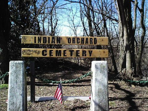
| Description | : | Originally called the “Burying Ground,” this is Terre Haute’s oldest cemetery. The land was set aside in 1821 in the original survey of Terre Haute as a burying ground for Terre Haute residents. It was located on Out-Lot 3, north of the town and next to the Wabash River, being approximately 2 acres in size. It was officially closed to new burials in 1839. After it closed, the land was eventually sold for commercial purposes and developed. Most of the cemetery is presently covered by a building that was constructed in 1930. An... Read More |
frequently asked questions (FAQ):
-
Where is Indian Orchard Cemetery?
Indian Orchard Cemetery is located at Terre Haute, Vigo County ,Indiana ,USA.
-
Indian Orchard Cemetery cemetery's updated grave count on graveviews.com?
0 memorials
-
Where are the coordinates of the Indian Orchard Cemetery?
Latitude: 39.4726257
Longitude: -87.4189148
Nearby Cemetories:
1. Woodlawn Cemetery
Terre Haute, Vigo County, USA
Coordinate: 39.4815870, -87.4142000
2. Saint Joseph Cemetery
Terre Haute, Vigo County, USA
Coordinate: 39.4831100, -87.4162600
3. Vigo County Historical Society Museum
Terre Haute, Vigo County, USA
Coordinate: 39.4520480, -87.4104930
4. Barnhart Cemetery
West Terre Haute, Vigo County, USA
Coordinate: 39.5000700, -87.4382500
5. Bennett Cemetery
Sugar Creek Township, Vigo County, USA
Coordinate: 39.4627800, -87.4604600
6. Fort Harrison Cemetery
Terre Haute, Vigo County, USA
Coordinate: 39.5084200, -87.4125370
7. Grandview Cemetery
Terre Haute, Vigo County, USA
Coordinate: 39.4361000, -87.3927994
8. Vigo County Poor Farm Graveyard
Terre Haute, Vigo County, USA
Coordinate: 39.4978330, -87.3678330
9. Sisters of Providence Cemetery
Saint Mary-of-the-Woods, Vigo County, USA
Coordinate: 39.5094830, -87.4566440
10. Providence Community Cemetery
Saint Mary-of-the-Woods, Vigo County, USA
Coordinate: 39.5093200, -87.4576100
11. Church of the Immaculate Conception
Saint Mary-of-the-Woods, Vigo County, USA
Coordinate: 39.5096030, -87.4601840
12. Bethesda Cemetery
Sugar Creek Township, Vigo County, USA
Coordinate: 39.4732600, -87.4837980
13. Calvary Cemetery
Terre Haute, Vigo County, USA
Coordinate: 39.4746390, -87.3529060
14. Highland Lawn Cemetery
Terre Haute, Vigo County, USA
Coordinate: 39.4761130, -87.3489580
15. Saint Marys Village Church Cemetery
Saint Mary-of-the-Woods, Vigo County, USA
Coordinate: 39.5127300, -87.4696100
16. Rogers Cemetery
Vigo County, USA
Coordinate: 39.4972200, -87.3524700
17. Coltrin Cemetery
Vigo County, USA
Coordinate: 39.4875800, -87.3462700
18. Mount Pleasant Cemetery
Terre Haute, Vigo County, USA
Coordinate: 39.4263730, -87.3707270
19. Bethel Cemetery
Saint Mary-of-the-Woods, Vigo County, USA
Coordinate: 39.5203438, -87.4653320
20. Coal Creek Cemetery
Vigo County, USA
Coordinate: 39.5353250, -87.4246580
21. Jackson Cemetery
Harrison, Vigo County, USA
Coordinate: 39.5084900, -87.3516290
22. Caldwell Cemetery
West Terre Haute, Vigo County, USA
Coordinate: 39.4370220, -87.4882630
23. Markle Cemetery
North Terre Haute, Vigo County, USA
Coordinate: 39.5236015, -87.3610992
24. Durham Cemetery
Terre Haute, Vigo County, USA
Coordinate: 39.4089012, -87.4488983