
| Memorials | : | 1 |
| Location | : | Peoria, Peoria County, USA |
| Coordinate | : | 40.6808910, -89.6144130 |
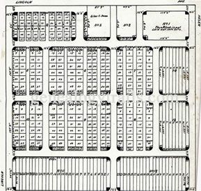
| Description | : | The City Cemetery began with the sale of five acres by Orin Hamlin to the Trustees of the Town of Peoria for $350 in 1839. The first lots of the Public Graveyard were sold in 1842 and the final interment took place in 1875. Officially the cemetery was closed in 1886 for public health reasons. Actual numbers of those buried in the City Cemetery are unknown because the burial records have been lost, but there have been 388 documented reinterrements between 1857 and 1902 in the Springdale Cemetery of Peoria from the City Cemetery. Some reinterrements to other area cemeteries... Read More |
frequently asked questions (FAQ):
-
Where is City Cemetery?
City Cemetery is located at 1300 block W. Lincoln Ave Peoria, Peoria County ,Illinois , 61605USA.
-
City Cemetery cemetery's updated grave count on graveviews.com?
1 memorials
-
Where are the coordinates of the City Cemetery?
Latitude: 40.6808910
Longitude: -89.6144130
Nearby Cemetories:
1. Saint Josephs Cemetery
West Peoria, Peoria County, USA
Coordinate: 40.7010994, -89.6239014
2. Saint Marys Cemetery
West Peoria, Peoria County, USA
Coordinate: 40.6927986, -89.6391983
3. Moffatt Cemetery
Peoria, Peoria County, USA
Coordinate: 40.6633200, -89.6325400
4. Lutheran Cemetery
Peoria, Peoria County, USA
Coordinate: 40.6768990, -89.6485977
5. Peoria Hebrew Cemetery
West Peoria, Peoria County, USA
Coordinate: 40.7010994, -89.6374969
6. Cathedral of Saint Mary of the Immaculate Concepti
Peoria, Peoria County, USA
Coordinate: 40.6983089, -89.5849428
7. Parkview Cemetery
Peoria, Peoria County, USA
Coordinate: 40.7141991, -89.6181030
8. First Federated Columbarium
Peoria, Peoria County, USA
Coordinate: 40.7307396, -89.6036758
9. Fon du Lac Township Cemetery
East Peoria, Tazewell County, USA
Coordinate: 40.6758003, -89.5475006
10. Saint Pauls Episcopal Cathedral Church Yard
Peoria, Peoria County, USA
Coordinate: 40.7313310, -89.6003720
11. Veterans of Foreign Wars Memorial Park
East Peoria, Tazewell County, USA
Coordinate: 40.6754060, -89.5466640
12. Universalist Unitarian Church Memorial Garden
Peoria, Peoria County, USA
Coordinate: 40.7286670, -89.6408187
13. Springdale Cemetery and Mausoleum
Peoria, Peoria County, USA
Coordinate: 40.7233400, -89.5744090
14. Pottstown Cemetery
Pottstown, Peoria County, USA
Coordinate: 40.7205963, -89.6602631
15. Whispering Woods Pet Cemetery
Peoria, Peoria County, USA
Coordinate: 40.7216530, -89.5685730
16. Peoria State Hospital Cemetery
Bartonville, Peoria County, USA
Coordinate: 40.6338882, -89.6589584
17. Roelfs Family Cemetery
Bartonville, Peoria County, USA
Coordinate: 40.6473310, -89.6802340
18. Peoria County Farm Cemetery
Peoria, Peoria County, USA
Coordinate: 40.6913440, -89.6983910
19. Fagotte Cemetery
East Peoria, Tazewell County, USA
Coordinate: 40.6273920, -89.5608300
20. Saint Michael and All Angels Church Columbarium
Peoria, Peoria County, USA
Coordinate: 40.7471180, -89.5937660
21. Saint Johns Lutheran Cemetery
Bartonville, Peoria County, USA
Coordinate: 40.6564450, -89.6984660
22. Trial Cemetery
Bartonville, Peoria County, USA
Coordinate: 40.6279373, -89.6713104
23. Zion Evangelical United Methodist Church Cemetery
Groveland, Tazewell County, USA
Coordinate: 40.6196500, -89.5704600
24. Rinkenberger Cemetery
Robein, Tazewell County, USA
Coordinate: 40.6798300, -89.5113200