
| Memorials | : | 0 |
| Location | : | Boston, Suffolk County, USA |
| Coordinate | : | 42.3499600, -71.0681900 |
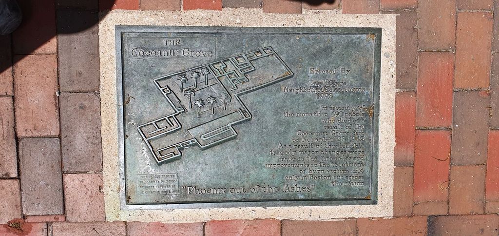
| Description | : | On the evening of November 28, 1942 a fire that started in the Melody Lounge swept through the Cocoanut Grove nightclub, killing more than 490 people. Overcrowding, locked exit doors and toxic flammable furnishings all contributed to the death toll, the highest in the history of Boston. The lessons from this tragedy saved the lives of many future fire victims; fire safety codes and public building regulations were strengthened and the treatment of burn injuries and smoke inhalation changed dramatically. The above is from a plaque placed by the Boston Historical Society, which is displayed on the wall... Read More |
frequently asked questions (FAQ):
-
Where is Cocoanut Grove Fire Memorial?
Cocoanut Grove Fire Memorial is located at 17 Piedmont Street Boston, Suffolk County ,Massachusetts , 02116USA.
-
Cocoanut Grove Fire Memorial cemetery's updated grave count on graveviews.com?
0 memorials
-
Where are the coordinates of the Cocoanut Grove Fire Memorial?
Latitude: 42.3499600
Longitude: -71.0681900
Nearby Cemetories:
1. Central Burying Ground
Boston, Suffolk County, USA
Coordinate: 42.3526300, -71.0659500
2. Old South Church
Boston, Suffolk County, USA
Coordinate: 42.3500500, -71.0779000
3. Trinity Church Tombs (Defunct)
Boston, Suffolk County, USA
Coordinate: 42.3549300, -71.0597500
4. Granary Burying Ground
Boston, Suffolk County, USA
Coordinate: 42.3572400, -71.0613500
5. Cathedral of the Holy Cross Crypt
Boston, Suffolk County, USA
Coordinate: 42.3408200, -71.0697400
6. Kings Chapel Burying Ground
Boston, Suffolk County, USA
Coordinate: 42.3583340, -71.0600370
7. South Burying Ground
Boston, Suffolk County, USA
Coordinate: 42.3382600, -71.0741000
8. Saint Matthews Cemetery (Defunct)
South Boston, Suffolk County, USA
Coordinate: 42.3379940, -71.0497180
9. Copp's Hill Burying Ground
Boston, Suffolk County, USA
Coordinate: 42.3670100, -71.0560800
10. Christ Church Cemetery
Boston, Suffolk County, USA
Coordinate: 42.3664900, -71.0545200
11. Eliot Burying Ground
Roxbury, Suffolk County, USA
Coordinate: 42.3318890, -71.0811970
12. Saint Augustine Cemetery
South Boston, Suffolk County, USA
Coordinate: 42.3339900, -71.0491800
13. Charlestown Revolutionary War Memorial
Charlestown, Suffolk County, USA
Coordinate: 42.3745800, -71.0601800
14. Warren Cemetery (Defunct)
Boston, Suffolk County, USA
Coordinate: 42.3269700, -71.0825500
15. Phipps Street Burying Ground
Charlestown, Suffolk County, USA
Coordinate: 42.3766300, -71.0673000
16. Bunker Hill Monument
Charlestown, Suffolk County, USA
Coordinate: 42.3762360, -71.0607300
17. South Boston Farm Cemetery (Defunct)
South Boston, Suffolk County, USA
Coordinate: 42.3388510, -71.0326710
18. Bunker Hill Burying Ground
Charlestown, Suffolk County, USA
Coordinate: 42.3789300, -71.0621200
19. Hawes Burying Ground
South Boston, Suffolk County, USA
Coordinate: 42.3340607, -71.0345078
20. Union Cemetery
South Boston, Suffolk County, USA
Coordinate: 42.3340440, -71.0344730
21. Warren Anatomical Museum
Boston, Suffolk County, USA
Coordinate: 42.3351300, -71.1036100
22. Saint Margaret's Convent Columbarium
Roxbury, Suffolk County, USA
Coordinate: 42.3260000, -71.0940700
23. Saint Francis de Sales Cemetery
Charlestown, Suffolk County, USA
Coordinate: 42.3815420, -71.0658620
24. Christ's Church
Brookline, Norfolk County, USA
Coordinate: 42.3421500, -71.1104200