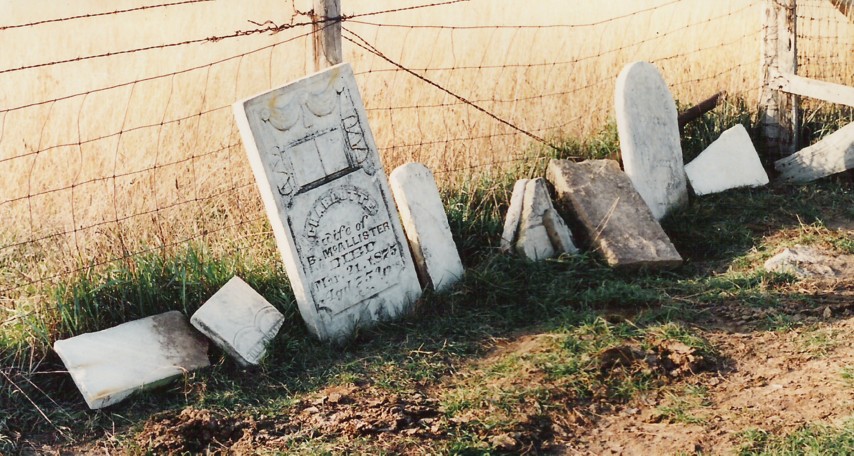
| Memorials | : | 0 |
| Location | : | Cummingsville, Olmsted County, USA |
| Coordinate | : | 43.9162260, -92.2586870 |
| Description | : | Located on what was the James Wentz farm, as of 1989. This is near Cummingsville, Orion Twp. Olmsted Co. Minnesota All readable headstones were photographed in August 1989. The actual graves are no longer in existence, they had been plowed over by farmers who owned the land and all the headstones had been piled up along a fence. |
frequently asked questions (FAQ):
-
Where is Coffin Cemetery?
Coffin Cemetery is located at Cummingsville, Olmsted County ,Minnesota ,USA.
-
Coffin Cemetery cemetery's updated grave count on graveviews.com?
0 memorials
-
Where are the coordinates of the Coffin Cemetery?
Latitude: 43.9162260
Longitude: -92.2586870
Nearby Cemetories:
1. Cline Cemetery
Eyota, Olmsted County, USA
Coordinate: 43.9413986, -92.2442017
2. Evangelical Lutheran Church Cemetery
Eyota, Olmsted County, USA
Coordinate: 43.9482420, -92.2490470
3. Orion Center Cemetery
Cummingsville, Olmsted County, USA
Coordinate: 43.8833008, -92.2572021
4. Cummingsville Cemetery
Cummingsville, Olmsted County, USA
Coordinate: 43.8666670, -92.2572220
5. Edith Wright Farm Cemetery
Eyota, Olmsted County, USA
Coordinate: 43.9666710, -92.2347183
6. Walter McConnell Farm Cemetery
Eyota, Olmsted County, USA
Coordinate: 43.9805603, -92.2763901
7. Ben Bear Cemetery
Eyota, Olmsted County, USA
Coordinate: 43.9805603, -92.2819366
8. Oak Grove Cemetery
Eyota, Olmsted County, USA
Coordinate: 43.9836006, -92.2581024
9. Holy Redeemer Cemetery
Eyota, Olmsted County, USA
Coordinate: 43.9855995, -92.2596970
10. Marion Cemetery
Marion, Olmsted County, USA
Coordinate: 43.9480591, -92.3494415
11. Sodom Cemetery
Fillmore County, USA
Coordinate: 43.8333015, -92.3024979
12. Union Cemetery
Pleasant Grove, Olmsted County, USA
Coordinate: 43.8698300, -92.3802300
13. Saint Paul Lutheran Cemetery
Chatfield, Fillmore County, USA
Coordinate: 43.8339005, -92.1755981
14. Calvary Cemetery
Chatfield, Fillmore County, USA
Coordinate: 43.8325005, -92.1735992
15. Randall Fork Cemetery
Eyota, Olmsted County, USA
Coordinate: 44.0194397, -92.2750015
16. Chatfield Cemetery
Chatfield, Fillmore County, USA
Coordinate: 43.8325005, -92.1714020
17. Chester Cemetery
Chester, Olmsted County, USA
Coordinate: 44.0002785, -92.3458328
18. Evergreen Cemetery
Dover, Olmsted County, USA
Coordinate: 43.9850006, -92.1438980
19. Fairview Cemetery
Simpson, Olmsted County, USA
Coordinate: 43.9131012, -92.4088974
20. United Church of Christ Cemetery
Viola, Olmsted County, USA
Coordinate: 44.0210686, -92.2202530
21. Saint Pauls United Church of Christ Cemetery
Eyota, Olmsted County, USA
Coordinate: 44.0212570, -92.2205310
22. Stone Church Cemetery
Sumner, Fillmore County, USA
Coordinate: 43.8114357, -92.3295975
23. Saint Marys Cemetery
Chatfield, Fillmore County, USA
Coordinate: 43.8269005, -92.1493988
24. Saint Bridgets Catholic Church Cemetery
Simpson, Olmsted County, USA
Coordinate: 43.9230423, -92.4351883

