
| Memorials | : | 0 |
| Location | : | Ashmore Township, Coles County, USA |
| Coordinate | : | 39.5221510, -88.0508280 |
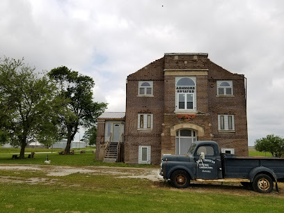
| Description | : | The Coles County Farm, Poor Farm, or Almshouse, was built in 1916 and was closed in 1979. It later was opened as Ashmore Estates as housing for developmentally disabled adults. That closed in 1987. It was next opened in 2006 for haunted house tours and other spooky events. Local persons commonly refer to the location as Ashmore Estates, but the majority of the burials occurred while it was the County Poor Farm. |
frequently asked questions (FAQ):
-
Where is Coles County Poor Farm Cemetery?
Coles County Poor Farm Cemetery is located at Ashmore Estates Ashmore Township, Coles County ,Illinois ,USA.
-
Coles County Poor Farm Cemetery cemetery's updated grave count on graveviews.com?
0 memorials
-
Where are the coordinates of the Coles County Poor Farm Cemetery?
Latitude: 39.5221510
Longitude: -88.0508280
Nearby Cemetories:
1. Enon-Ashmore Cemetery
Ashmore Township, Coles County, USA
Coordinate: 39.5034610, -88.0406840
2. Reed Cemetery
Ashmore Township, Coles County, USA
Coordinate: 39.5141983, -88.0227966
3. Ashmore Cemetery
Ashmore, Coles County, USA
Coordinate: 39.5269318, -88.0189972
4. Miller-Coartney Cemetery
Ashmore Township, Coles County, USA
Coordinate: 39.5355988, -88.0852966
5. Wells Cemetery
Ashmore Township, Coles County, USA
Coordinate: 39.4995540, -88.0224370
6. Zimmerman Cemetery
Ashmore Township, Coles County, USA
Coordinate: 39.5534300, -88.0576900
7. Olmstead Cemetery
Ashmore Township, Coles County, USA
Coordinate: 39.4891750, -88.0447940
8. Brooks Cemetery
Ashmore Township, Coles County, USA
Coordinate: 39.5430984, -88.0852966
9. Mitchell Cemetery
Ashmore Township, Coles County, USA
Coordinate: 39.5582500, -88.0487600
10. Lafferty Cemetery Polecat Creek
Ashmore Township, Coles County, USA
Coordinate: 39.5070400, -88.0949900
11. Shoots Cemetery
Ashmore Township, Coles County, USA
Coordinate: 39.4824905, -88.0719070
12. Lafler Cemetery
Ashmore Township, Coles County, USA
Coordinate: 39.5200005, -88.1074982
13. Saint Omer Cemetery
Ashmore Township, Coles County, USA
Coordinate: 39.5682983, -88.0307999
14. Otterbein Cemetery
Hutton Township, Coles County, USA
Coordinate: 39.4655418, -88.0186462
15. Freeman Cemetery
Hutton Township, Coles County, USA
Coordinate: 39.4700619, -88.0955331
16. Winkleblack Cemetery
Morgan Township, Coles County, USA
Coordinate: 39.5449982, -88.1268997
17. Huckaba Cemetery
Charleston Township, Coles County, USA
Coordinate: 39.4990082, -88.1330414
18. Grant Cemetery
Hutton Township, Coles County, USA
Coordinate: 39.4656296, -88.1000900
19. Craig Cemetery
Morgan Township, Coles County, USA
Coordinate: 39.5400009, -88.1371994
20. Knoch Cemetery
Morgan Township, Coles County, USA
Coordinate: 39.5863991, -88.0877991
21. Lumbrick Collom Cemetery
Charleston Township, Coles County, USA
Coordinate: 39.4990660, -88.1421860
22. Methodist Church Cemetery
Westfield, Clark County, USA
Coordinate: 39.4557304, -88.0004883
23. Waite Cemetery
Kansas, Edgar County, USA
Coordinate: 39.5139008, -87.9511032
24. Maple Hill Cemetery
Westfield, Clark County, USA
Coordinate: 39.4591990, -87.9925120