
| Memorials | : | 0 |
| Location | : | Philadelphia, Philadelphia County, USA |
| Coordinate | : | 39.9532700, -75.2068200 |
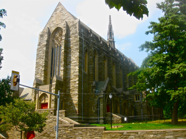
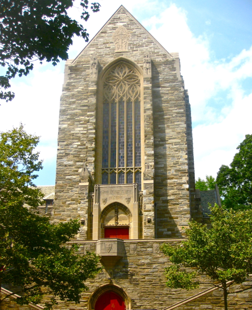
| Description | : | This now deconsecrated Episcopal church was the chapel of the Philadelphia Divinity School, which closed in 1974, when it merged with the Episcopal Theological School at Cambridge, Massachusetts, to become The Episcopal Divinity School. The original Episcopal church of St. Andrew, designed by John Haviland and built in 1822, was located at 256 S. 8th st.; sold by the Episcopal diocese in 1922, and is now the Greek Orthodox Cathedral of St. George. |
frequently asked questions (FAQ):
-
Where is Collegiate Church of Saint Andrew Churchyard?
Collegiate Church of Saint Andrew Churchyard is located at 4201 Spruce st. Philadelphia, Philadelphia County ,Pennsylvania , 19104USA.
-
Collegiate Church of Saint Andrew Churchyard cemetery's updated grave count on graveviews.com?
0 memorials
-
Where are the coordinates of the Collegiate Church of Saint Andrew Churchyard?
Latitude: 39.9532700
Longitude: -75.2068200
Nearby Cemetories:
1. African Friends to Harmony Burial Ground
Philadelphia, Philadelphia County, USA
Coordinate: 39.9562090, -75.2051990
2. Walnut Street Associated Presbyterian Church Cemetery
Philadelphia County, USA
Coordinate: 39.9542550, -75.2015500
3. Blockley Almshouse Cemetery #2
Philadelphia, Philadelphia County, USA
Coordinate: 39.9456510, -75.1976500
4. Asbury Methodist Episcopal Church Cemetery (Defunct)
Philadelphia, Philadelphia County, USA
Coordinate: 39.9543910, -75.1900490
5. Leech Family Burial Grounds
Philadelphia, Philadelphia County, USA
Coordinate: 39.9405120, -75.2164140
6. Friends Lower Burial Ground (Defunct)
Wynnefield, Philadelphia County, USA
Coordinate: 39.9569301, -75.1862932
7. Hanover Street Burial Grounds (Defunct)
Philadelphia, Philadelphia County, USA
Coordinate: 39.9498920, -75.2306800
8. Mikveh Israel Cemetery #03
Philadelphia, Philadelphia County, USA
Coordinate: 39.9612083, -75.2302933
9. Dexter Park
Philadelphia, Philadelphia County, USA
Coordinate: 39.9433690, -75.1833820
10. Bartram's Garden National Historic Landmark
Philadelphia, Philadelphia County, USA
Coordinate: 39.9320831, -75.2135162
11. Blockley Baptist Church Cemetery (Defunct)
Philadelphia, Philadelphia County, USA
Coordinate: 39.9691760, -75.2265040
12. First Unitarian Church Burial Ground
Philadelphia, Philadelphia County, USA
Coordinate: 39.9525050, -75.1762730
13. Magdalen Society of Philadelphia Asylum Grounds
Philadelphia, Philadelphia County, USA
Coordinate: 39.9579780, -75.1737950
14. Saint Clement's Anglo-Catholic Church Crypt Chapel Columbarium
Philadelphia County, USA
Coordinate: 39.9564182, -75.1733746
15. Cathedral Basilica of Saints Peter and Paul
Philadelphia, Philadelphia County, USA
Coordinate: 39.9573517, -75.1682358
16. Owen and Palmer Burial Ground
Yeadon, Delaware County, USA
Coordinate: 39.9375610, -75.2409470
17. Friends Western Burial Ground (Defunct)
Philadelphia, Philadelphia County, USA
Coordinate: 39.9563313, -75.1669462
18. Mount Moriah Cemetery
Philadelphia, Philadelphia County, USA
Coordinate: 39.9336014, -75.2382965
19. Church of the Epiphany Churchyard (Defunct)
Philadelphia, Philadelphia County, USA
Coordinate: 39.9512880, -75.1658620
20. Moyamensing Almshouse Cemetery
Kensington, Philadelphia County, USA
Coordinate: 39.9411710, -75.1680600
21. First Independent Christian Church Cemetery
Philadelphia, Philadelphia County, USA
Coordinate: 39.9502510, -75.1636880
22. Graceland Cemetery
Yeadon, Delaware County, USA
Coordinate: 39.9387474, -75.2473373
23. Hebrew Mutual Burial Ground
Philadelphia, Philadelphia County, USA
Coordinate: 39.9291946, -75.2390474
24. Friends Southwestern Burial Ground
Upper Darby, Delaware County, USA
Coordinate: 39.9565010, -75.2522202