
| Memorials | : | 2 |
| Location | : | Halsham, East Riding of Yorkshire Unitary Authority, England |
| Coordinate | : | 53.7317000, -0.0754680 |
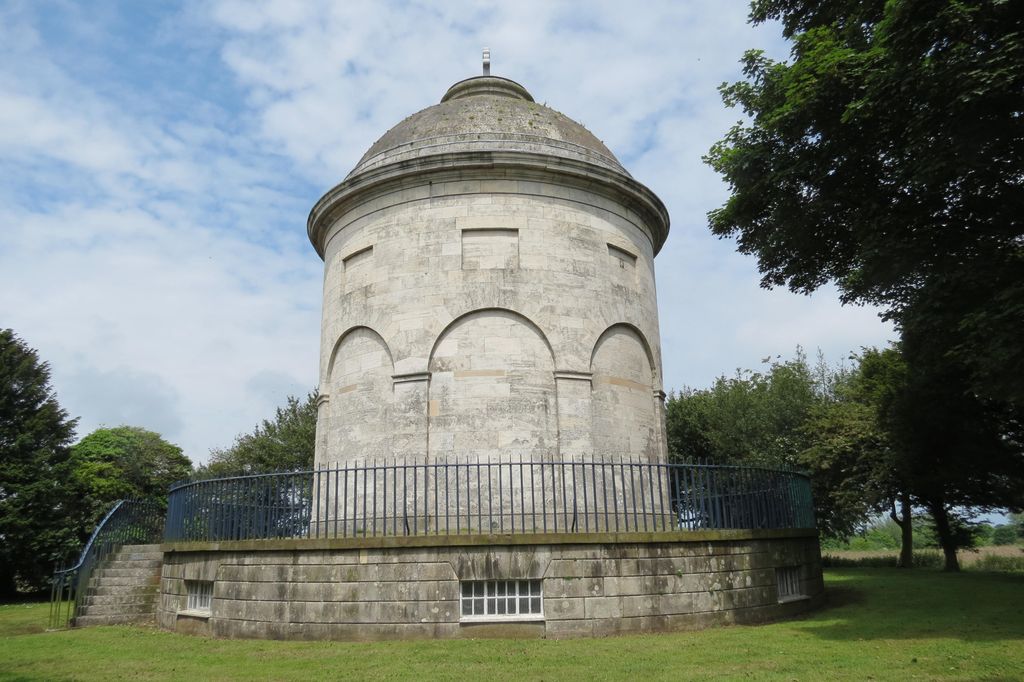
| Description | : | This mausoleum dates from 1792-1802 and was built for Sir Edward Constable. It contains memorial tablets and urns to members of the Constable family from the 18th century and later. One is inscribed: 'Bones of the Ancestors of the Family of Constable Collected in The Old Vault of the Family adjoining the Church of Halsham and transferred to the Mausoleum on the 23rd of August 1802'. |
frequently asked questions (FAQ):
-
Where is Constable Family Mausoleum?
Constable Family Mausoleum is located at Halsham, East Riding of Yorkshire Unitary Authority ,East Riding of Yorkshire ,England.
-
Constable Family Mausoleum cemetery's updated grave count on graveviews.com?
2 memorials
-
Where are the coordinates of the Constable Family Mausoleum?
Latitude: 53.7317000
Longitude: -0.0754680
Nearby Cemetories:
1. All Saints Churchyard
Halsham, East Riding of Yorkshire Unitary Authority, England
Coordinate: 53.7308200, -0.0790490
2. Keyingham Municipal Cemetery
Keyingham, East Riding of Yorkshire Unitary Authority, England
Coordinate: 53.7113730, -0.1073830
3. St Nicholas Churchyard
Keyingham, East Riding of Yorkshire Unitary Authority, England
Coordinate: 53.7111100, -0.1149800
4. St. Peter and St. Paul Churchyard
Burton Pidsea, East Riding of Yorkshire Unitary Authority, England
Coordinate: 53.7611900, -0.1022900
5. All Saints Churchyard
Burstwick, East Riding of Yorkshire Unitary Authority, England
Coordinate: 53.7342100, -0.1403200
6. Burstwick Cemetery
Burstwick, East Riding of Yorkshire Unitary Authority, England
Coordinate: 53.7347400, -0.1405800
7. St Lawrence Churchyard
Elstronwick, East Riding of Yorkshire Unitary Authority, England
Coordinate: 53.7722500, -0.1268400
8. St Margaret Churchyard
Hilston, East Riding of Yorkshire Unitary Authority, England
Coordinate: 53.7824600, -0.0452000
9. St Michael Churchyard
Garton, East Riding of Yorkshire Unitary Authority, England
Coordinate: 53.7998850, -0.0727840
10. St. Nicholas' Churchyard
Hollym, East Riding of Yorkshire Unitary Authority, England
Coordinate: 53.7063300, 0.0359100
11. St Peter Churchyard
Humbleton, East Riding of Yorkshire Unitary Authority, England
Coordinate: 53.7953180, -0.1396210
12. St Augustine Churchyard
Hedon, East Riding of Yorkshire Unitary Authority, England
Coordinate: 53.7412750, -0.1996850
13. Hedon Town Cemetery
Hedon, East Riding of Yorkshire Unitary Authority, England
Coordinate: 53.7417400, -0.2051700
14. St. Nicholas' Churchyard
Holmpton, East Riding of Yorkshire Unitary Authority, England
Coordinate: 53.6888400, 0.0689200
15. St. Bartholomew Churchyard
Aldbrough, East Riding of Yorkshire Unitary Authority, England
Coordinate: 53.8297390, -0.1107480
16. Aldbrough Cemetery
Aldbrough, East Riding of Yorkshire Unitary Authority, England
Coordinate: 53.8288200, -0.1257900
17. St Peter Churchyard
Bilton, East Riding of Yorkshire Unitary Authority, England
Coordinate: 53.7778700, -0.2466700
18. Eastern Cemetery
Kingston upon Hull, Kingston upon Hull Unitary Authority, England
Coordinate: 53.7565610, -0.2639000
19. Marfleet Lane Jewish Cemetery
Kingston upon Hull, Kingston upon Hull Unitary Authority, England
Coordinate: 53.7489900, -0.2670840
20. St Giles Churchyard
Marfleet, Kingston upon Hull Unitary Authority, England
Coordinate: 53.7492700, -0.2674200
21. Delhi Street Jewish Cemetery
Kingston upon Hull, Kingston upon Hull Unitary Authority, England
Coordinate: 53.7485900, -0.2793900
22. Old Hebrew Congregation Burial Ground
Kingston upon Hull, Kingston upon Hull Unitary Authority, England
Coordinate: 53.7483380, -0.2794940
23. Hedon Road Crematorium and Columbarium
Kingston upon Hull, Kingston upon Hull Unitary Authority, England
Coordinate: 53.7512800, -0.2888200
24. Hedon Road Cemetery
Kingston upon Hull, Kingston upon Hull Unitary Authority, England
Coordinate: 53.7479100, -0.2938200