
| Memorials | : | 0 |
| Location | : | Grand Cane, DeSoto Parish, USA |
| Coordinate | : | 32.0127983, -93.8242035 |
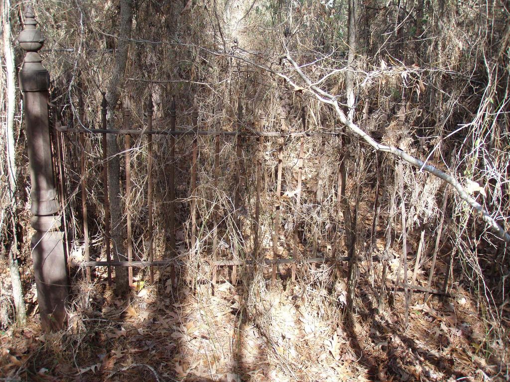
| Description | : | This cemetery is located in deep woods. It is listed on USGS list of 1980 features. There is no pictures of the cemetery or markers, so no one has visited the cemetery of recent times. It is inactive. |
frequently asked questions (FAQ):
-
Where is Cook Cemetery?
Cook Cemetery is located at Parish Rd 275 Grand Cane, DeSoto Parish ,Louisiana , 71032USA.
-
Cook Cemetery cemetery's updated grave count on graveviews.com?
0 memorials
-
Where are the coordinates of the Cook Cemetery?
Latitude: 32.0127983
Longitude: -93.8242035
Nearby Cemetories:
1. Friendship Baptist Church Cemetery
Grand Cane, DeSoto Parish, USA
Coordinate: 32.0427800, -93.8180600
2. Prude Cemetery
Stanley, DeSoto Parish, USA
Coordinate: 31.9772600, -93.8348000
3. Friendship Cemetery
Grand Cane, DeSoto Parish, USA
Coordinate: 32.0503006, -93.8244019
4. Morning Glory Baptist Church Cemetery
Mansfield, DeSoto Parish, USA
Coordinate: 31.9988900, -93.7733300
5. New Morning Glory Baptist Temple Church Cemetery
Mansfield, DeSoto Parish, USA
Coordinate: 31.9856100, -93.7637600
6. Frazier Cemetery
Mansfield, DeSoto Parish, USA
Coordinate: 32.0263420, -93.7532900
7. Mary Evergreen Baptist Church Cemetery
Grand Cane, DeSoto Parish, USA
Coordinate: 32.0644000, -93.7782500
8. Chreene Cemetery
Stanley, DeSoto Parish, USA
Coordinate: 32.0059000, -93.9018000
9. Grand Cane Cemetery
Grand Cane, DeSoto Parish, USA
Coordinate: 32.0756836, -93.7997665
10. Creech Cemetery
Mansfield, DeSoto Parish, USA
Coordinate: 31.9806100, -93.8936000
11. Ebenezer Cemetery
Lula, DeSoto Parish, USA
Coordinate: 31.9586000, -93.7773000
12. New Morning Glory Baptist Church Cemetery
Pineville, Rapides Parish, USA
Coordinate: 31.9656950, -93.8857080
13. Shady Grove Cemetery
Mansfield, DeSoto Parish, USA
Coordinate: 31.9502400, -93.7831700
14. Old Zion Baptist Church Cemetery
Grand Cane, DeSoto Parish, USA
Coordinate: 32.0849000, -93.8415000
15. Wood Springs Baptist Church Cemetery
Logansport, DeSoto Parish, USA
Coordinate: 32.0647000, -93.9056800
16. Williams Family Cemetery
Logansport, DeSoto Parish, USA
Coordinate: 32.0028000, -93.9266000
17. Cornerstone Cemetery
Logansport, DeSoto Parish, USA
Coordinate: 32.0103490, -93.9275750
18. Bethel Cemetery
Logansport, DeSoto Parish, USA
Coordinate: 32.0169100, -93.9277000
19. Moore's Chapel Cemetery
Mansfield, DeSoto Parish, USA
Coordinate: 32.0125000, -93.7205000
20. Union Cemetery
Longstreet, DeSoto Parish, USA
Coordinate: 32.0808000, -93.8942000
21. Stephenson Cemetery
South Mansfield, DeSoto Parish, USA
Coordinate: 31.9806000, -93.7243600
22. Mount Olivet Cemetery
Stanley, DeSoto Parish, USA
Coordinate: 31.9608000, -93.9161000
23. Zion Hill Cemetery
Grand Cane, DeSoto Parish, USA
Coordinate: 32.0962000, -93.7731000
24. First Community Church Cemetery
Mansfield, DeSoto Parish, USA
Coordinate: 32.0151200, -93.7127000