
| Memorials | : | 0 |
| Location | : | Moultonborough, Carroll County, USA |
| Phone | : | 6039233622 |
| Website | : | hikenewengland.com |
| Coordinate | : | 43.7435585, -71.4621048 |
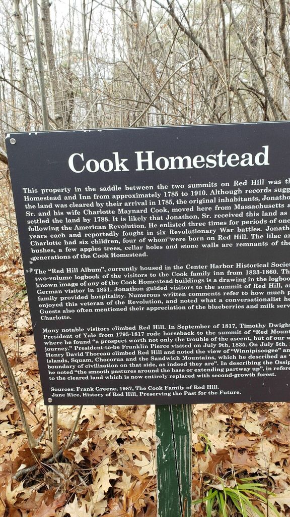
| Description | : | At Center Harbor take 25 B -Bean Road to Sibley Rd, at the Red Hill trail take the Cabin Trail 1.3 mi. at the fork in the trail --it will lead to 3 old cellar holes, the cemetery is in that area |
frequently asked questions (FAQ):
-
Where is Cook Family Cemetery?
Cook Family Cemetery is located at Bean Road Moultonborough, Carroll County ,New Hampshire , 03254USA.
-
Cook Family Cemetery cemetery's updated grave count on graveviews.com?
0 memorials
-
Where are the coordinates of the Cook Family Cemetery?
Latitude: 43.7435585
Longitude: -71.4621048
Nearby Cemetories:
1. Red Hill Cemetery
Moultonborough, Carroll County, USA
Coordinate: 43.7260920, -71.4756830
2. Bean Cemetery
Moultonborough, Carroll County, USA
Coordinate: 43.7242150, -71.4752270
3. Campbell Cemetery
Center Harbor, Belknap County, USA
Coordinate: 43.7372686, -71.5012926
4. Center Harbor Memorial Park
Center Harbor, Belknap County, USA
Coordinate: 43.7144800, -71.4728100
5. Mason Cemetery
Moultonborough, Carroll County, USA
Coordinate: 43.7574500, -71.4184000
6. Dana Graveyard
Center Harbor, Belknap County, USA
Coordinate: 43.7102780, -71.4816670
7. Lakeview Cemetery
Center Harbor, Belknap County, USA
Coordinate: 43.7073700, -71.4633300
8. Haines Cemetery
Union, Carroll County, USA
Coordinate: 43.7734000, -71.4331000
9. Rollins Cemetery
Moultonborough, Carroll County, USA
Coordinate: 43.7430420, -71.4106610
10. Sturtevant Cemetery
Center Harbor, Belknap County, USA
Coordinate: 43.7100000, -71.4883330
11. Senter-Coe Cemetery
Center Harbor, Belknap County, USA
Coordinate: 43.7047220, -71.4663890
12. Morse Cemetery
Center Harbor, Belknap County, USA
Coordinate: 43.7086000, -71.4867000
13. Smith-Morse Cemetery
Sandwich, Carroll County, USA
Coordinate: 43.7768000, -71.4301000
14. Moulton-Beede Cemetery
Sandwich, Carroll County, USA
Coordinate: 43.7774000, -71.4276000
15. Follett Cemetery
Meredith, Belknap County, USA
Coordinate: 43.7002000, -71.4871000
16. Freese Cemetery
Moultonborough, Carroll County, USA
Coordinate: 43.7616670, -71.4008330
17. Holland Hill Cemetery
Moultonborough, Carroll County, USA
Coordinate: 43.7620300, -71.3995400
18. Mason Cemetery
Center Sandwich, Carroll County, USA
Coordinate: 43.7858000, -71.4258000
19. Robinson Cemetery
Meredith, Belknap County, USA
Coordinate: 43.6920050, -71.4758710
20. Thompson Cemetery
Center Harbor, Belknap County, USA
Coordinate: 43.7036070, -71.5099560
21. Fogg Cemetery
Meredith, Belknap County, USA
Coordinate: 43.6894440, -71.4750000
22. East Holderness Cemetery
Holderness, Grafton County, USA
Coordinate: 43.7112700, -71.5257800
23. Canney Hill Cemetery
Center Harbor, Belknap County, USA
Coordinate: 43.6984000, -71.5099000
24. Brown Cemetery
Moultonborough, Carroll County, USA
Coordinate: 43.7476220, -71.3815960