
| Memorials | : | 0 |
| Location | : | Coopers, Baldwin County, USA |
| Coordinate | : | 32.9796400, -83.2905300 |
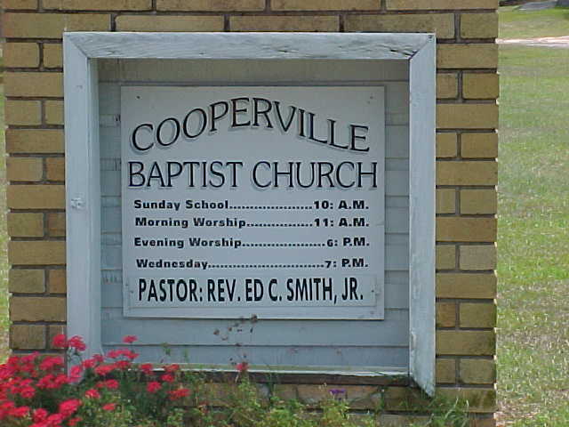
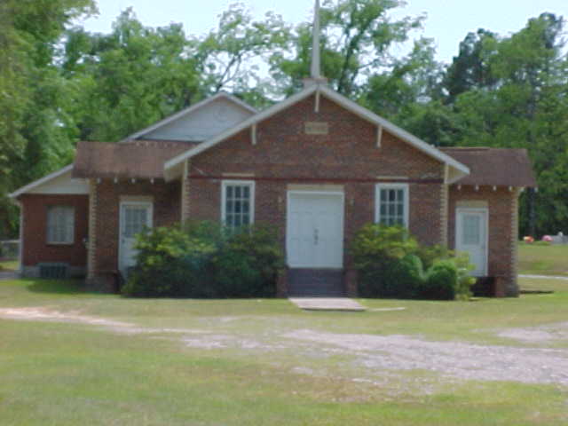
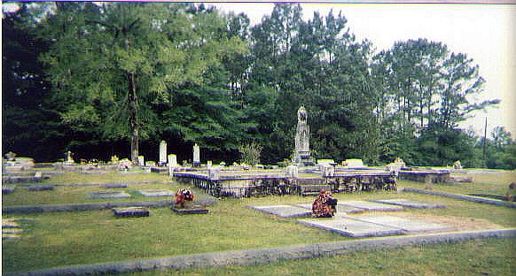
| Description | : | At the intersection of US-441 and GA-243, travel south on GA-243 for 4.4 miles. Turn right on Coopers Road and travel .7 miles. Turn left on Berry Road and travel for 135 yards. Cemetery at front with cemetery to rear of church. As of May 2014, all headstones, markers, and monuments have been photographed. At that time there were, at a minimum, 14 unmarked graves indicated by either a slab or sunken ground. |
frequently asked questions (FAQ):
-
Where is Cooperville Baptist Church Cemetery?
Cooperville Baptist Church Cemetery is located at Coopers, Baldwin County ,Georgia ,USA.
-
Cooperville Baptist Church Cemetery cemetery's updated grave count on graveviews.com?
0 memorials
-
Where are the coordinates of the Cooperville Baptist Church Cemetery?
Latitude: 32.9796400
Longitude: -83.2905300
Nearby Cemetories:
1. Scott's Chapel CME Church Cemetery
Coopers, Baldwin County, USA
Coordinate: 32.9716400, -83.2834300
2. Matilda Chapel Church Cemetery
Coopers, Baldwin County, USA
Coordinate: 32.9664700, -83.2933100
3. Batson Family Cemetery
Coopers, Baldwin County, USA
Coordinate: 32.9864700, -83.2676400
4. Ivey Family Cemetery
Baldwin County, USA
Coordinate: 32.9996900, -83.2995300
5. Torrance Chapel Baptist Church Cemetery
Coopers, Baldwin County, USA
Coordinate: 32.9922300, -83.3129700
6. Camp Creek Primitive Baptist Church Cemetery
Coopers, Baldwin County, USA
Coordinate: 32.9997200, -83.3084100
7. Emmanuel Baptist Church Cemetery
Baldwin County, USA
Coordinate: 32.9938970, -83.2623340
8. Hubbard Cemetery
Coopers, Baldwin County, USA
Coordinate: 32.9752500, -83.2491100
9. Union Hill Methodist Church Cemetery
Coopers, Baldwin County, USA
Coordinate: 32.9747000, -83.3336000
10. Mount Pleasant Baptist Church Cemetery
Mount Pleasant, Baldwin County, USA
Coordinate: 32.9830100, -83.2467200
11. Rice Cemetery
Baldwin County, USA
Coordinate: 33.0056381, -83.3309097
12. Torrance Family Cemetery
Baldwin County, USA
Coordinate: 32.9900210, -83.3430050
13. Newton Cemetery
Baldwin County, USA
Coordinate: 32.9622002, -83.3416977
14. Baldwin County Poorhouse Cemetery
Hardwick, Baldwin County, USA
Coordinate: 32.9776700, -83.2326700
15. Tollison Family Cemetery
Scottsboro, Baldwin County, USA
Coordinate: 32.9853600, -83.2323100
16. Salem Baptist Church Cemetery
Browns Crossing, Baldwin County, USA
Coordinate: 33.0090600, -83.3407600
17. Oak Grove Methodist Church Cemetery
Scottsboro, Baldwin County, USA
Coordinate: 33.0036790, -83.2359020
18. Mitchell Zion Baptist Church Cemetery
Milledgeville, Baldwin County, USA
Coordinate: 32.9511110, -83.3438890
19. Old duBignon Plantation Cemetery
Milledgeville, Baldwin County, USA
Coordinate: 33.0152500, -83.2435390
20. Huff Family Cemetery
Coopers, Baldwin County, USA
Coordinate: 32.9918098, -83.3534393
21. Leonidas Smith Family Cemetery
Milledgeville, Baldwin County, USA
Coordinate: 33.0156000, -83.3392400
22. Lester Family Cemetery #2
Milledgeville, Baldwin County, USA
Coordinate: 33.0132830, -83.3460830
23. West-Neal Cemetery
Pancras, Baldwin County, USA
Coordinate: 32.9987500, -83.3561400
24. Hall Cemetery #2
Milledgeville, Baldwin County, USA
Coordinate: 32.9351700, -83.3389200