
| Memorials | : | 0 |
| Location | : | Horton, Renfrew County, Canada |
| Coordinate | : | 45.4684307, -76.6346983 |
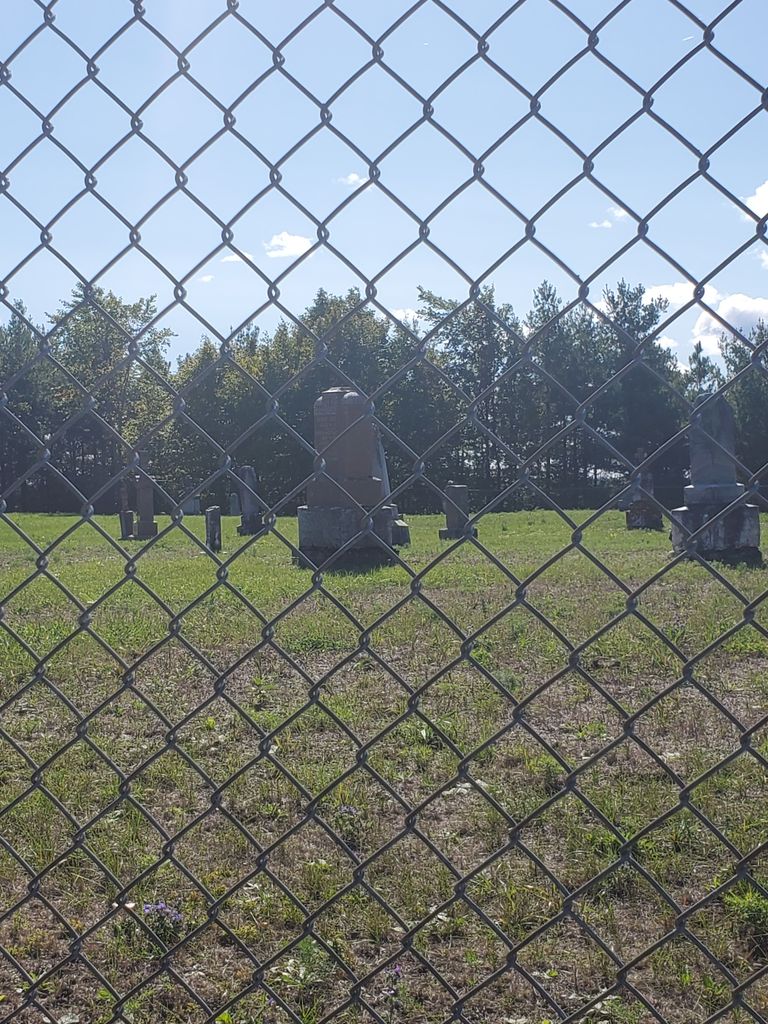
| Description | : | The Costello Cemetery, was the Catholic side of the Whitton Road(Then named Martin Road). Across the road was the non-Catholic Cemetery named the Martin Cemetery. The deed dating back to July 18th, 1857, shows Thomas & Mary Costello sold to the Roman Catholic Episcopal Corporation of Bytown(Ottawa) for 5 Schilling, 1 acre of land. (Source: Heritage Renfrew website). The cemetery is surrounded by high chain link fence. It is gated & locked. |
frequently asked questions (FAQ):
-
Where is Costello Cemetery?
Costello Cemetery is located at 1198 Whitton Road Horton, Renfrew County ,Ontario ,Canada.
-
Costello Cemetery cemetery's updated grave count on graveviews.com?
0 memorials
-
Where are the coordinates of the Costello Cemetery?
Latitude: 45.4684307
Longitude: -76.6346983
Nearby Cemetories:
1. Old Martin Cemetery
Horton, Renfrew County, Canada
Coordinate: 45.4673350, -76.6318680
2. McLaren Cemetery
Renfrew, Renfrew County, Canada
Coordinate: 45.4553800, -76.6632200
3. Thompson Hill Cemetery
Thompson Hill, Renfrew County, Canada
Coordinate: 45.4567900, -76.6710200
4. Saint Francis Xavier Cemetery
Renfrew, Renfrew County, Canada
Coordinate: 45.4872100, -76.6921600
5. Goshen Public Cemetery
Goshen, Renfrew County, Canada
Coordinate: 45.4377130, -76.5794520
6. North Horton Cemetery
Renfrew, Renfrew County, Canada
Coordinate: 45.5177800, -76.6718355
7. Fraser Cemetery
Burnstown, Renfrew County, Canada
Coordinate: 45.3903130, -76.6384360
8. Castleford Union Cemetery
Castleford, Renfrew County, Canada
Coordinate: 45.5100900, -76.5395200
9. Admaston Cemetery
Admaston, Renfrew County, Canada
Coordinate: 45.4568750, -76.7694830
10. Austin United Cemetery
Clarendon Front, Outaouais Region, Canada
Coordinate: 45.5589610, -76.5529840
11. Gillies Family Cemetery
Braeside, Renfrew County, Canada
Coordinate: 45.4168100, -76.4994000
12. Old Clarendon Cemetery
Clarendon, Outaouais Region, Canada
Coordinate: 45.5342450, -76.5005850
13. Springtown Protestant Cemetery
Springtown, Renfrew County, Canada
Coordinate: 45.3540590, -76.6487820
14. Rosebank Cemetery
Rosebank, Renfrew County, Canada
Coordinate: 45.5251000, -76.7829110
15. Saint Gabriel's Roman Catholic Cemetery
Springtown, Renfrew County, Canada
Coordinate: 45.3468860, -76.6621210
16. Flat Rapids Cemetery
Arnprior, Renfrew County, Canada
Coordinate: 45.4150030, -76.4734690
17. White Lake Cemetery
White Lake, Renfrew County, Canada
Coordinate: 45.3744950, -76.5166330
18. Protestant Cemetery of Portage du Fort
Portage-du-Fort, Outaouais Region, Canada
Coordinate: 45.5926410, -76.6584030
19. St. James Roman Catholic Cemetery
Portage-du-Fort, Outaouais Region, Canada
Coordinate: 45.5929000, -76.6582800
20. St. George Anglican Church Cemetery
Portage-du-Fort, Outaouais Region, Canada
Coordinate: 45.5934170, -76.6678210
21. Sand Point Public Cemetery
Sand Point, Renfrew County, Canada
Coordinate: 45.4941830, -76.4566060
22. St. Alexander's Cemetery
Sand Point, Renfrew County, Canada
Coordinate: 45.4921040, -76.4452380
23. St. James the Greater Cemetery
Portage-du-Fort, Outaouais Region, Canada
Coordinate: 45.6091700, -76.6508400
24. Haley Cemetery
Haley Station, Renfrew County, Canada
Coordinate: 45.5722300, -76.7880700