
| Memorials | : | 8 |
| Location | : | Clover Lick, Pocahontas County, USA |
| Coordinate | : | 38.3332610, -80.0120390 |
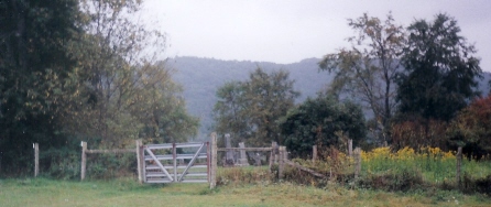
| Description | : | From the town of Cass, Pocahontas County, West Virginia, go west on State Route 66 about 2 miles to the intersection with County Route 1 (Back Mountain Road). Turn left on County Route 1 and go about 3 or 4 miles to the intersection with County Route 9 and turn right. Go about 1/2 mile to County Route 9/2 (Beverage Road) and turn left. Turn right in the first driveway and go to the house at the top. This is the residence of the property owner, Mr. Lee Gardner (in 2005). The cemetery is west... Read More |
frequently asked questions (FAQ):
-
Where is Coyner Cemetery?
Coyner Cemetery is located at Clover Lick, Pocahontas County ,West Virginia ,USA.
-
Coyner Cemetery cemetery's updated grave count on graveviews.com?
8 memorials
-
Where are the coordinates of the Coyner Cemetery?
Latitude: 38.3332610
Longitude: -80.0120390
Nearby Cemetories:
1. Corso Cemetery
Pocahontas County, USA
Coordinate: 38.3129712, -80.0063618
2. Grimes Cemetery
Clover Lick, Pocahontas County, USA
Coordinate: 38.3148800, -79.9903110
3. William Folks Burial Site
Monterville, Randolph County, USA
Coordinate: 38.3100000, -80.0500000
4. Meeks Cemetery
Stony Bottom, Pocahontas County, USA
Coordinate: 38.3544790, -79.9644250
5. Stony Bottom Cemetery
Stony Bottom, Pocahontas County, USA
Coordinate: 38.3569590, -79.9656560
6. William Sharp, Jr. Cemetery
Pocahontas County, USA
Coordinate: 38.2925960, -80.0429690
7. Fairview Cemetery
Marlinton, Pocahontas County, USA
Coordinate: 38.2816280, -80.0259560
8. Gay Cemetery
Marlinton, Pocahontas County, USA
Coordinate: 38.2892685, -80.0795517
9. Mount Pleasant Cemetery
Marlinton, Pocahontas County, USA
Coordinate: 38.2816750, -80.0747760
10. McLaughlin-Sutton Cemetery
Cass, Pocahontas County, USA
Coordinate: 38.3866350, -79.9343720
11. Tacy Cemetery
Cass, Pocahontas County, USA
Coordinate: 38.3866150, -79.9343410
12. Hively Cemetery
Dunmore, Pocahontas County, USA
Coordinate: 38.2877640, -79.9238850
13. Gibson Cemetery
Slaty Fork, Pocahontas County, USA
Coordinate: 38.3678017, -80.1128006
14. Big Springs Presbyterian
Linwood, Pocahontas County, USA
Coordinate: 38.4169140, -80.0402500
15. Gay Cemetery
Edray, Pocahontas County, USA
Coordinate: 38.2768660, -80.0963400
16. Brownsburg Cemetery
Marlinton, Pocahontas County, USA
Coordinate: 38.2599800, -80.0737610
17. Deer Creek Cemetery
Deer Creek, Pocahontas County, USA
Coordinate: 38.3884040, -79.9226290
18. Hannah Cemetery
Pocahontas County, USA
Coordinate: 38.3636017, -80.1200027
19. Bethel Church Cemetery
Dunmore, Pocahontas County, USA
Coordinate: 38.2582000, -79.9487000
20. Bethel Cemetery
Marlinton, Pocahontas County, USA
Coordinate: 38.2582300, -79.9483500
21. Wilfong Cemetery
Marlinton, Pocahontas County, USA
Coordinate: 38.2515920, -80.0629000
22. Varner Cemetery
Linwood, Pocahontas County, USA
Coordinate: 38.4117012, -80.0785980
23. Gordon Dilley Cemetery
Marlinton, Pocahontas County, USA
Coordinate: 38.2528600, -79.9493640
24. Mount Zion Cemetery
Frost, Pocahontas County, USA
Coordinate: 38.2676150, -79.9237830