
| Memorials | : | 0 |
| Location | : | Marble Falls, Burnet County, USA |
| Coordinate | : | 30.5284000, -98.2649000 |
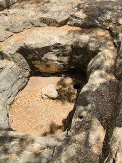
| Description | : | According to the inscription of the Dead Man's Hole plaque: Entomologist Ferdinand Lueders made the earliest recorded discover of this cave in 1821. Notorious in the Civil War era, the hole is believed to have been the dumping ground for up to 17 bodies, including those of pro-Union Judge John R. Scott and settle Adolph Hoppe, several reconstruction-era county government officials, and Ben McKeever, who had a conflict with local freedmen. An oak tree which once stood over the cave was said to have rope marks caused by hangings. Powerful gases prevented thorough exploration of the site until... Read More |
frequently asked questions (FAQ):
-
Where is Dead Man's Hole?
Dead Man's Hole is located at Marble Falls, Burnet County ,Texas ,USA.
-
Dead Man's Hole cemetery's updated grave count on graveviews.com?
0 memorials
-
Where are the coordinates of the Dead Man's Hole?
Latitude: 30.5284000
Longitude: -98.2649000

Nearby Cemetories:
1. Richter Cemetery
Marble Falls, Burnet County, USA
Coordinate: 30.5471992, -98.2397003
2. Burnam-Smithart Cemetery
Marble Falls, Burnet County, USA
Coordinate: 30.5182991, -98.2260971
3. Pleasant Valley Cemetery
Marble Falls, Burnet County, USA
Coordinate: 30.5699997, -98.2422028
4. Marble Falls City Cemetery
Marble Falls, Burnet County, USA
Coordinate: 30.5716286, -98.2927475
5. Fuchs Cemetery
Cottonwood Shores, Burnet County, USA
Coordinate: 30.5606900, -98.3262420
6. Rockvale Cemetery
Spicewood, Burnet County, USA
Coordinate: 30.5016994, -98.1968994
7. Pangle Cemetery
Burnet County, USA
Coordinate: 30.5781002, -98.2118988
8. Horseshoe Bay Mausoleum
Marble Falls, Burnet County, USA
Coordinate: 30.5306500, -98.3520500
9. Richland Cemetery
Smithwick, Burnet County, USA
Coordinate: 30.5800000, -98.1927700
10. Fowler Cemetery
Spicewood, Burnet County, USA
Coordinate: 30.4713993, -98.1883011
11. Konvicka Cemetery
Burnet County, USA
Coordinate: 30.6180992, -98.2694016
12. Holloway Cemetery
Burnet County, USA
Coordinate: 30.4932995, -98.1577988
13. Mormon Mill Cemetery
Burnet County, USA
Coordinate: 30.6322002, -98.2319031
14. Lewis Family Cemetery
Burnet County, USA
Coordinate: 30.5249996, -98.1361008
15. Smithwick Cemetery
Smithwick, Burnet County, USA
Coordinate: 30.5641500, -98.1415130
16. Fairland Cemetery
Marble Falls, Burnet County, USA
Coordinate: 30.6419700, -98.2840100
17. Round Mountain Cemetery
Round Mountain, Blanco County, USA
Coordinate: 30.4381008, -98.3506012
18. Joy Cemetery
Burnet County, USA
Coordinate: 30.6436996, -98.2956009
19. Tobey Cemetery
Marble Falls, Burnet County, USA
Coordinate: 30.6436005, -98.3255997
20. Goeth-Wenmohs Family Cemetery
Blanco County, USA
Coordinate: 30.3996890, -98.2502230
21. Wolf Crossing Cemetery
Highland Haven, Burnet County, USA
Coordinate: 30.6194000, -98.3936005
22. Cypress Mill Cemetery
Cypress Mill, Blanco County, USA
Coordinate: 30.3774200, -98.2477300
23. Haynie Flat Cemetery
Spicewood, Burnet County, USA
Coordinate: 30.4631004, -98.1025009
24. Ross Family Cemetery
Round Mountain, Blanco County, USA
Coordinate: 30.4112833, -98.1477167