
| Memorials | : | 0 |
| Location | : | Smithwick, Burnet County, USA |
| Coordinate | : | 30.5800000, -98.1927700 |
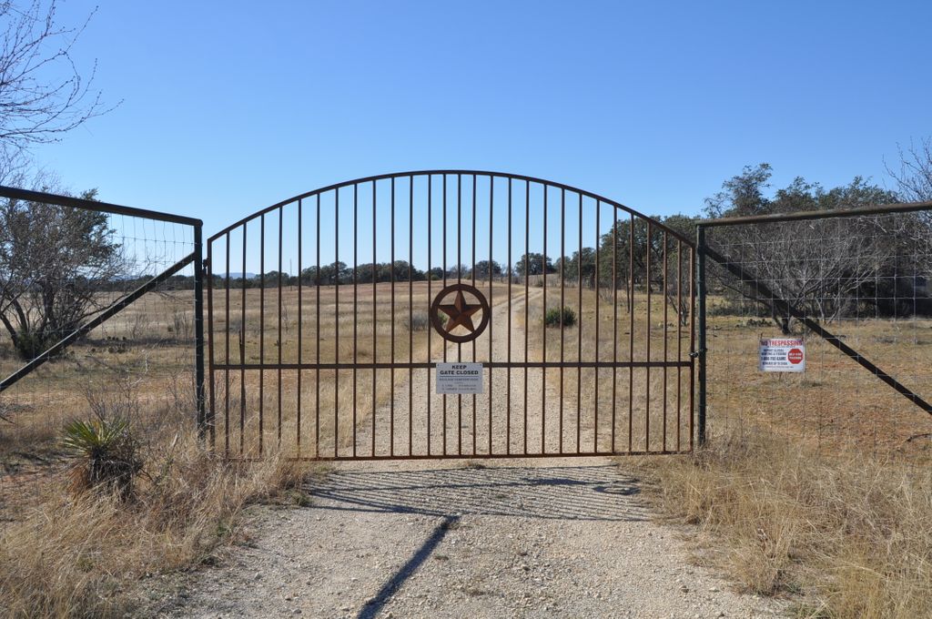
| Description | : | To reach this cemetery from Marble Falls go east on FM1431 to the intersection with CR 341A. This is a private dirt road maintained by the Richland Cemetery Association and has a locked gate. A sign on the gate gives the telephone numbers of two association members who have the combination to the padlock on the gate. Once the gate is opened follow the dirt road approximately 0.5 miles to the fenced in cemetery. The cemetery established in 1889 and the Cemetery Association in the 1980's. The oldest marked grave is that of Tommie Hansell, son of S.B. and M.... Read More |
frequently asked questions (FAQ):
-
Where is Richland Cemetery?
Richland Cemetery is located at Smithwick, Burnet County ,Texas ,USA.
-
Richland Cemetery cemetery's updated grave count on graveviews.com?
0 memorials
-
Where are the coordinates of the Richland Cemetery?
Latitude: 30.5800000
Longitude: -98.1927700


Nearby Cemetories:
1. Pangle Cemetery
Burnet County, USA
Coordinate: 30.5781002, -98.2118988
2. Pleasant Valley Cemetery
Marble Falls, Burnet County, USA
Coordinate: 30.5699997, -98.2422028
3. Smithwick Cemetery
Smithwick, Burnet County, USA
Coordinate: 30.5641500, -98.1415130
4. Richter Cemetery
Marble Falls, Burnet County, USA
Coordinate: 30.5471992, -98.2397003
5. Mormon Mill Cemetery
Burnet County, USA
Coordinate: 30.6322002, -98.2319031
6. Burnam-Smithart Cemetery
Marble Falls, Burnet County, USA
Coordinate: 30.5182991, -98.2260971
7. Lewis Family Cemetery
Burnet County, USA
Coordinate: 30.5249996, -98.1361008
8. Konvicka Cemetery
Burnet County, USA
Coordinate: 30.6180992, -98.2694016
9. Rockvale Cemetery
Spicewood, Burnet County, USA
Coordinate: 30.5016994, -98.1968994
10. Dead Man's Hole
Marble Falls, Burnet County, USA
Coordinate: 30.5284000, -98.2649000
11. Marble Falls City Cemetery
Marble Falls, Burnet County, USA
Coordinate: 30.5716286, -98.2927475
12. Holloway Cemetery
Burnet County, USA
Coordinate: 30.4932995, -98.1577988
13. Fairland Cemetery
Marble Falls, Burnet County, USA
Coordinate: 30.6419700, -98.2840100
14. Fowler Cemetery
Spicewood, Burnet County, USA
Coordinate: 30.4713993, -98.1883011
15. Joy Cemetery
Burnet County, USA
Coordinate: 30.6436996, -98.2956009
16. Fuchs Cemetery
Cottonwood Shores, Burnet County, USA
Coordinate: 30.5606900, -98.3262420
17. Norred Cemetery
Burnet County, USA
Coordinate: 30.6968994, -98.1838989
18. Tobey Cemetery
Marble Falls, Burnet County, USA
Coordinate: 30.6436005, -98.3255997
19. Holland Cemetery
Burnet, Burnet County, USA
Coordinate: 30.7157993, -98.2121964
20. Haynie Flat Cemetery
Spicewood, Burnet County, USA
Coordinate: 30.4631004, -98.1025009
21. Horseshoe Bay Mausoleum
Marble Falls, Burnet County, USA
Coordinate: 30.5306500, -98.3520500
22. Lakeland Hills Memorial Park
Burnet, Burnet County, USA
Coordinate: 30.6784450, -98.3188500
23. Oatmeal Cemetery
Oatmeal, Burnet County, USA
Coordinate: 30.6964910, -98.0820880
24. Adian Family Cemetery
Burnet County, USA
Coordinate: 30.7348500, -98.2015700