
| Memorials | : | 16 |
| Location | : | Lewis and Clark County, USA |
| Coordinate | : | 47.2120000, -112.1116000 |
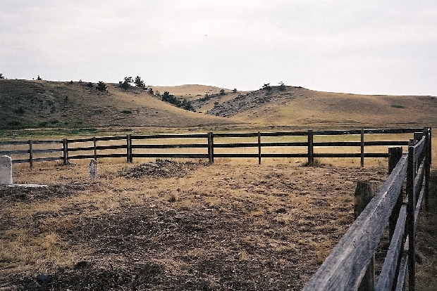
| Description | : | This cemetery is located on private property and observation is by escort only. It lies on a bench beside the Dearborn River above the present Dearborn Bridge on the Augusta - Wolf Creek highway. The property location is Township 17 North, Range 4 West, Section 21. The cemetery is located on private property and not accessible to the public. The Dearborn Crossing settlement began as a stage stop for travelers on the Mullan Road but it lasted less than 30 years. An old map marked the location as Dearborn City and another map named it Dearborn. Whatever name you give this... Read More |
frequently asked questions (FAQ):
-
Where is Dearborn Crossing Cemetery?
Dearborn Crossing Cemetery is located at Lewis and Clark County ,Montana ,USA.
-
Dearborn Crossing Cemetery cemetery's updated grave count on graveviews.com?
16 memorials
-
Where are the coordinates of the Dearborn Crossing Cemetery?
Latitude: 47.2120000
Longitude: -112.1116000

Nearby Cemetories:
1. Dearborn Cemetery
Lewis and Clark County, USA
Coordinate: 47.1643982, -112.2303009
2. Moore Grave
Lewis and Clark County, USA
Coordinate: 47.0969009, -112.0522003
3. Milford Colony Cemetery
Milford Colony, Lewis and Clark County, USA
Coordinate: 47.3310000, -112.2070000
4. Saint Peter Mission Cemetery
Saint Peter, Cascade County, USA
Coordinate: 47.3005000, -111.9210000
5. Craig Cemetery
Craig, Lewis and Clark County, USA
Coordinate: 47.0780060, -111.9697380
6. Gibson Ranch Cemetery
Wolf Creek, Lewis and Clark County, USA
Coordinate: 47.2513800, -112.3542470
7. Flat Creek Cemetery
Augusta, Lewis and Clark County, USA
Coordinate: 47.3360890, -112.3494960
8. Carterville Cemetery
Wolf Creek, Lewis and Clark County, USA
Coordinate: 47.0069000, -112.0855000
9. Cadotte Family Ranch Cemetery
Lincoln, Lewis and Clark County, USA
Coordinate: 47.0596000, -112.4148800
10. Hillside Cemetery
Cascade, Cascade County, USA
Coordinate: 47.2873000, -111.7027000
11. Elk Creek Colony Cemetery
Augusta, Lewis and Clark County, USA
Coordinate: 47.4620000, -112.3218000
12. Cascade Colony Cemetery
Sun River, Cascade County, USA
Coordinate: 47.4393000, -111.8169000
13. Chesnut Valley Cemetery
Cascade County, USA
Coordinate: 47.2482986, -111.6453018
14. Sieben Ranch Cemetery
Wolf Creek, Lewis and Clark County, USA
Coordinate: 46.8882900, -112.1224700
15. Augusta Cemetery
Augusta, Lewis and Clark County, USA
Coordinate: 47.4961014, -112.4039001
16. Fort Shaw Military Cemetery
Fort Shaw, Cascade County, USA
Coordinate: 47.5065700, -111.8358500
17. Fair Haven Colony Cemetery
Fair Haven Colony, Cascade County, USA
Coordinate: 47.4047000, -111.6279000
18. Sunset Hills Cemetery
Fairfield, Teton County, USA
Coordinate: 47.5946400, -111.9870900
19. Sun River Cemetery
Sun River, Cascade County, USA
Coordinate: 47.5242004, -111.7166977
20. Fairfield Mennonite Cemetery
Fairfield, Teton County, USA
Coordinate: 47.6149840, -111.9804050
21. United Church of Christ Columbarium
Fairfield, Teton County, USA
Coordinate: 47.6158400, -111.9784300
22. Castner Falls Cemetery
Cascade County, USA
Coordinate: 47.3139000, -111.5160980
23. Cobb Ranch Cemetery
Augusta, Lewis and Clark County, USA
Coordinate: 47.4370100, -112.6716600
24. Ulm Cemetery
Ulm, Cascade County, USA
Coordinate: 47.4400000, -111.5230000