
| Memorials | : | 2 |
| Location | : | Leachtown, Wood County, USA |
| Coordinate | : | 39.1434180, -81.4475970 |
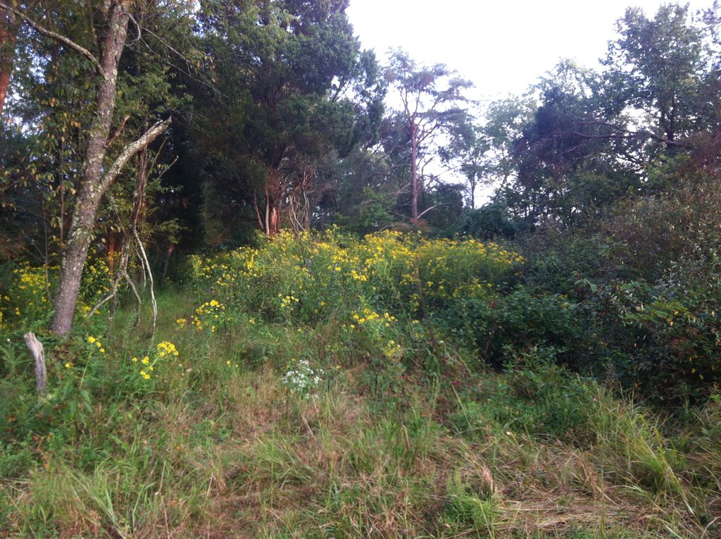
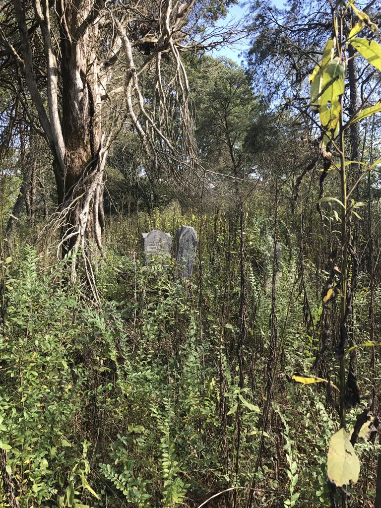
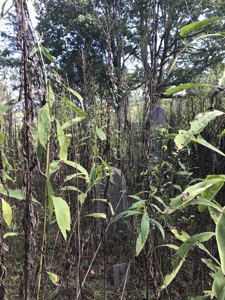
| Description | : | Also known as the Leach Cemetery. On W.Va. Rt. 47, turn onto Leachtown Lane. Proceed to almost the end of Leachtown Lane and turn right. It is near the Little Kanawha River. The easiest way to access this cemetery is to stop at the blue, two-story home of Ronald Eddy (868 Leachtown Lane) and ask for permission. Then proceed down the "old road" bed past the pond. The cemetery is on top of the hill at the back of the cornfield. There will be a cleared trail just to the right of the hill. Follow that for about... Read More |
frequently asked questions (FAQ):
-
Where is Deem Cemetery?
Deem Cemetery is located at Leachtown, Wood County ,West Virginia ,USA.
-
Deem Cemetery cemetery's updated grave count on graveviews.com?
2 memorials
-
Where are the coordinates of the Deem Cemetery?
Latitude: 39.1434180
Longitude: -81.4475970
Nearby Cemetories:
1. Leachtown Cemetery
Leachtown, Wood County, USA
Coordinate: 39.1495700, -81.4352300
2. Vaught Chapel Cemetery
Leachtown, Wood County, USA
Coordinate: 39.1516200, -81.4343400
3. Kanawha Baptist Cemetery
Leachtown, Wood County, USA
Coordinate: 39.1492700, -81.4284500
4. Bibbee Cemetery
Wood County, USA
Coordinate: 39.1394210, -81.4256580
5. Boice Cemetery
Slate, Wood County, USA
Coordinate: 39.1254330, -81.4489830
6. Merrill Chapel United Methodist Church Cemetery
Elizabeth, Wirt County, USA
Coordinate: 39.1261800, -81.4371500
7. Wilson Cemetery
Slate, Wood County, USA
Coordinate: 39.1182400, -81.4612560
8. Dye Cemetery
Mineral Wells, Wood County, USA
Coordinate: 39.1545790, -81.4803500
9. Hickman Cemetery
Wood County, USA
Coordinate: 39.1707490, -81.4265360
10. Beulah Humble Presbyterian Church Cemetery
Elizabeth, Wirt County, USA
Coordinate: 39.1171989, -81.4216995
11. Steed Cemetery
Wirt County, USA
Coordinate: 39.1372500, -81.4034170
12. Slate Chapel Cemetery Old
Slate, Wood County, USA
Coordinate: 39.1084000, -81.4747000
13. Spencer Cemetery
Chesterville, Wood County, USA
Coordinate: 39.1576690, -81.4975690
14. Deem Cemetery
Mineral Wells, Wood County, USA
Coordinate: 39.1455994, -81.5017014
15. Chesterville Cemetery
Mineral Wells, Wood County, USA
Coordinate: 39.1603310, -81.4998870
16. Slate Chapel Cemetery
Slate, Wood County, USA
Coordinate: 39.1067000, -81.4791000
17. Pribble Cemetery
Newark, Wirt County, USA
Coordinate: 39.1193333, -81.3992500
18. Buffington Cemetery
Newark, Wirt County, USA
Coordinate: 39.1392780, -81.3865560
19. Hammond Cemetery
Elizabeth, Wirt County, USA
Coordinate: 39.0982780, -81.4246670
20. Lee - Pickering Cemetery
Newark, Wirt County, USA
Coordinate: 39.1144170, -81.3938610
21. Slate Baptist Cemetery
Slate, Wood County, USA
Coordinate: 39.1022400, -81.4887500
22. West Cemetery
Elizabeth, Wirt County, USA
Coordinate: 39.1018060, -81.4071390
23. Oak Hill Cemetery
Wirt County, USA
Coordinate: 39.1016998, -81.4068985
24. Beha Cemetery
Hanna, Wood County, USA
Coordinate: 39.1730200, -81.3914800