| Memorials | : | 0 |
| Location | : | Frog Level, Caroline County, USA |
| Coordinate | : | 37.9722150, -77.3409180 |
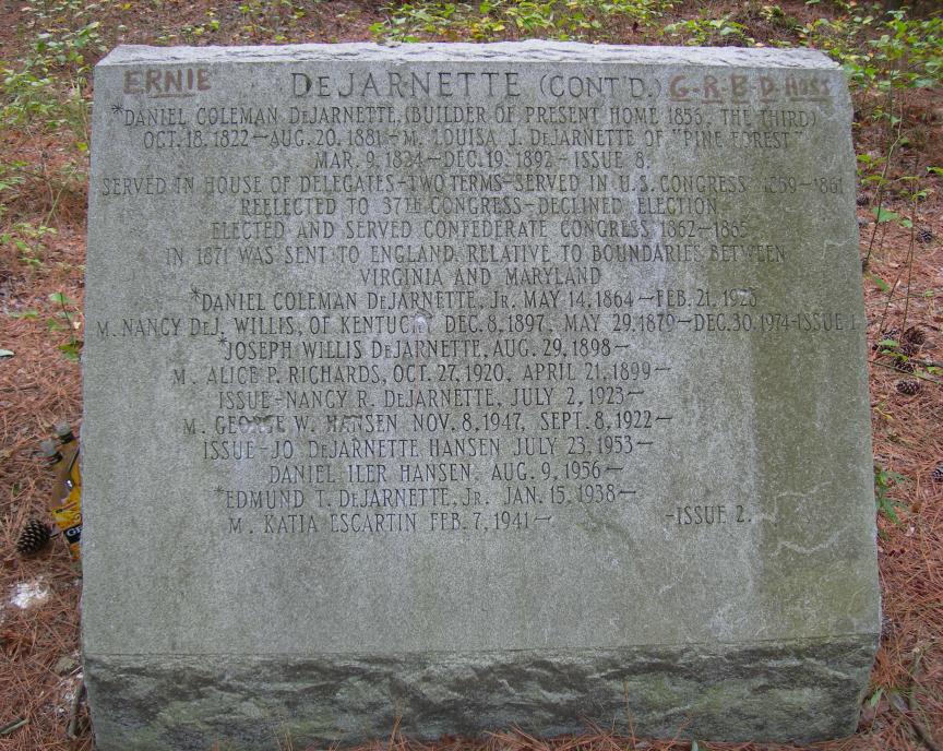
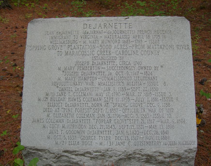
| Description | : | The DeJarnette family cenotaph is located approximately 20 yards east of Route 301 in the woods in Caroline County, VA just north of the town of Frog Level. It is a granite marker sitting by itself in the woods off the highway and is not protected by a fence. Unfortunately, the marker has been somewhat vandalized but all text was still readable when photographed on 3 September 2009. The area around the cenotaph is obviously a gathering place for young people to party and the area is littered with empty beer bottles. Such a shame. The front... Read More |
frequently asked questions (FAQ):
-
Where is DeJarnette Memorial?
DeJarnette Memorial is located at Frog Level, Caroline County ,Virginia ,USA.
-
DeJarnette Memorial cemetery's updated grave count on graveviews.com?
0 memorials
-
Where are the coordinates of the DeJarnette Memorial?
Latitude: 37.9722150
Longitude: -77.3409180
Nearby Cemetories:
1. Baylor Family Cemetery
Bowling Green, Caroline County, USA
Coordinate: 38.0012300, -77.3411300
2. Saint James Baptist Church Cemetery
Milford, Caroline County, USA
Coordinate: 37.9890920, -77.3066290
3. Rosehill Cemetery
Caroline County, USA
Coordinate: 37.9417000, -77.3735962
4. Mount Salem Memorial Park
Kemp Corner, Caroline County, USA
Coordinate: 37.9322300, -77.3689100
5. Evergreen Cemetery
Milford, Caroline County, USA
Coordinate: 38.0261002, -77.3356018
6. Mount Tabor Baptist Church Cemetery
Shumansville, Caroline County, USA
Coordinate: 37.9298477, -77.2843552
7. Mount Oni Baptist Church Cemetery
Ruther Glen, Caroline County, USA
Coordinate: 37.9319580, -77.4057450
8. Reedy Baptist Church Cemetery
Ruther Glen, Caroline County, USA
Coordinate: 37.9166610, -77.3879770
9. Saint Paul’s UMC Cemetery
Ruther Glen, Caroline County, USA
Coordinate: 37.9168480, -77.3936870
10. Ivy Church Burial Ground (Defunct)
Sparta, Caroline County, USA
Coordinate: 37.9902730, -77.2546410
11. Mount Hermon Baptist Church Cemetery
Shumansville, Caroline County, USA
Coordinate: 37.9306950, -77.2667670
12. Reedy Church Burial Ground
Doggetts Fork, Caroline County, USA
Coordinate: 37.8990960, -77.3556240
13. Antioch Christian Church Cemetery
Bowling Green, Caroline County, USA
Coordinate: 38.0475311, -77.3459396
14. Bowling Green Methodist Church Cemetery
Bowling Green, Caroline County, USA
Coordinate: 38.0483627, -77.3463287
15. Dickinson Family Cemetery
Bowling Green, Caroline County, USA
Coordinate: 38.0488530, -77.3443570
16. Calvary Baptist Church Cemetery
Bowling Green, Caroline County, USA
Coordinate: 38.0495780, -77.3484490
17. Creek Church Burial Ground
Poorhouse Corner, Caroline County, USA
Coordinate: 38.0363600, -77.2761600
18. Victory Deliverance Church of God Cemetery
Bowling Green, Caroline County, USA
Coordinate: 38.0575523, -77.3514786
19. Donahoe Family Cemetery
Ruther Glen, Caroline County, USA
Coordinate: 37.9410810, -77.4484000
20. Saint John Baptist Church Cemetery Old Section
Woodford, Caroline County, USA
Coordinate: 38.0316500, -77.4282100
21. Lakewood Cemetery
Bowling Green, Caroline County, USA
Coordinate: 38.0630989, -77.3463974
22. Saint John Baptist Church Cemetery
Woodford, Caroline County, USA
Coordinate: 38.0302190, -77.4300210
23. Second Baptist Church Cemetery
Ruther Glen, Caroline County, USA
Coordinate: 37.9033940, -77.4168080
24. Loving Cemetery
Shumansville, Caroline County, USA
Coordinate: 37.9177800, -77.2387300


