
| Memorials | : | 0 |
| Location | : | Ruther Glen, Caroline County, USA |
| Coordinate | : | 37.9410810, -77.4484000 |
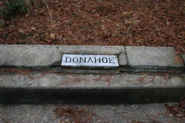
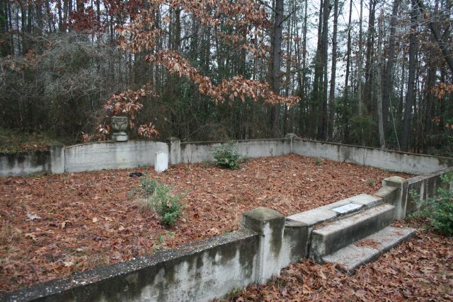
| Description | : | Located off Route 207 (Rogers Clark Boulevard) at Route 799 (Enterprise Parkway). The cemetery is on a small rise where Route 799 and Route 798 (Business Center Court) intersect, directly across from the Russell Stover Candy outlet. |
frequently asked questions (FAQ):
-
Where is Donahoe Family Cemetery?
Donahoe Family Cemetery is located at Ruther Glen, Caroline County ,Virginia ,USA.
-
Donahoe Family Cemetery cemetery's updated grave count on graveviews.com?
0 memorials
-
Where are the coordinates of the Donahoe Family Cemetery?
Latitude: 37.9410810
Longitude: -77.4484000
Nearby Cemetories:
1. Saint Margarets Episcopal Church Cemetery
Ruther Glen, Caroline County, USA
Coordinate: 37.9226960, -77.4515480
2. Carmel Baptist Church Cemetery
Ruther Glen, Caroline County, USA
Coordinate: 37.9302250, -77.4807920
3. Middlebrook-Madison Family Cemetery
Ruther Glen, Caroline County, USA
Coordinate: 37.9234440, -77.4761670
4. Oxford Mount Zion Baptist Church Cemetery
Ruther Glen, Caroline County, USA
Coordinate: 37.9182010, -77.4785900
5. Mount Oni Baptist Church Cemetery
Ruther Glen, Caroline County, USA
Coordinate: 37.9319580, -77.4057450
6. Jericho Baptist Church Cemetery
Ruther Glen, Caroline County, USA
Coordinate: 37.9300850, -77.4971460
7. Second Baptist Church Cemetery
Ruther Glen, Caroline County, USA
Coordinate: 37.9033940, -77.4168080
8. Saint Paul’s UMC Cemetery
Ruther Glen, Caroline County, USA
Coordinate: 37.9168480, -77.3936870
9. Carpenter-Cobb Family Cemetery
Ruther Glen, Caroline County, USA
Coordinate: 37.9625600, -77.5054600
10. Reedy Baptist Church Cemetery
Ruther Glen, Caroline County, USA
Coordinate: 37.9166610, -77.3879770
11. Rosehill Cemetery
Caroline County, USA
Coordinate: 37.9417000, -77.3735962
12. Mount Salem Memorial Park
Kemp Corner, Caroline County, USA
Coordinate: 37.9322300, -77.3689100
13. Topping Castle Cemetery
Houstons Corner, Caroline County, USA
Coordinate: 37.9233180, -77.5428300
14. Old Wright Cemetery
Caroline County, USA
Coordinate: 38.0186005, -77.4621964
15. Wrights Burying Ground
Ladysmith, Caroline County, USA
Coordinate: 38.0191290, -77.4621270
16. Hill Family Cemetery at Mount Airy
Ruther Glen, Caroline County, USA
Coordinate: 37.9376400, -77.5515250
17. Mount Carmel Baptist Church Cemetery
Doswell, Hanover County, USA
Coordinate: 37.8986140, -77.5369690
18. Mount Hope Church Cemetery
Doswell, Hanover County, USA
Coordinate: 37.8638000, -77.4828033
19. Wrights Chapel Cemetery
Caroline County, USA
Coordinate: 38.0229150, -77.4597520
20. Haskins Family
Doswell, Hanover County, USA
Coordinate: 37.8619800, -77.4778180
21. Reedy Church Burial Ground
Doggetts Fork, Caroline County, USA
Coordinate: 37.8990960, -77.3556240
22. Bull Church Burial Ground (Defunct)
Ladysmith, Caroline County, USA
Coordinate: 38.0227280, -77.4935410
23. Belmont Cemetery
Doswell, Hanover County, USA
Coordinate: 37.8547324, -77.4783911
24. DeJarnette Memorial
Frog Level, Caroline County, USA
Coordinate: 37.9722150, -77.3409180