
| Memorials | : | 0 |
| Location | : | Kim, Las Animas County, USA |
| Coordinate | : | 37.6365200, -103.5854900 |
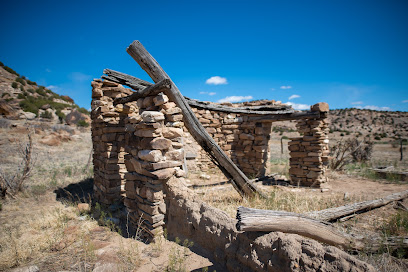
| Description | : | http://www.visitlajunta.net/comanche.html As you hike into Picketwire Canyon from the Withers Canyon Trailhead one of the first areas of unique interest you will find is the cemetery and ruins of the Dolores Mission. In 1871 a group of New Mexicans migrated up the Purgatory River to settle. The group led by Damacio Lopez consisted of 11 families and they were the first to establish a permanent settlement in the canyonlands. Traditionally most New Mexicans of the time were Catholic. The tiny settlement founded by Damacio did not have a church or priest. This was a quandary for the religious settlers at the... Read More |
frequently asked questions (FAQ):
-
Where is Dolores Mission Cemetery?
Dolores Mission Cemetery is located at Comanche National Grassland Kim, Las Animas County ,Colorado , 81049USA.
-
Dolores Mission Cemetery cemetery's updated grave count on graveviews.com?
0 memorials
-
Where are the coordinates of the Dolores Mission Cemetery?
Latitude: 37.6365200
Longitude: -103.5854900
Nearby Cemetories:
1. Martinez Cemetery
Otero County, USA
Coordinate: 37.7303009, -103.5002975
2. Higbee Cemetery
Higbee, Otero County, USA
Coordinate: 37.7630997, -103.4555969
3. Johnson Cemetery
Las Animas County, USA
Coordinate: 37.4730988, -103.6727982
4. Timpas Cemetery
Timpas, Otero County, USA
Coordinate: 37.8081000, -103.7681000
5. Pruett Cemetery
Bent County, USA
Coordinate: 37.7172012, -103.2897034
6. Cedar Hill Cemetery
Las Animas County, USA
Coordinate: 37.4366989, -103.2546997
7. Ormega Cemetery
La Junta, Otero County, USA
Coordinate: 37.9684000, -103.5770000
8. Saint Andrews Episcopal Church Columbarium
La Junta, Otero County, USA
Coordinate: 37.9809000, -103.5455000
9. Calvary Cemetery
La Junta, Otero County, USA
Coordinate: 37.9832000, -103.5622000
10. Fairview Cemetery
La Junta, Otero County, USA
Coordinate: 37.9873000, -103.5607000
11. Edenview Cemetery
Las Animas County, USA
Coordinate: 37.3353004, -103.3557968
12. Plum Valley Cemetery
Las Animas County, USA
Coordinate: 37.2467003, -103.5186005
13. Parker Cemetery
Las Animas County, USA
Coordinate: 37.2338982, -103.5975037
14. Saint Paul’s Lutheran Cemetery
Otero County, USA
Coordinate: 38.0342000, -103.4542000
15. Hillcrest Cemetery
Rocky Ford, Otero County, USA
Coordinate: 38.0388985, -103.7071991
16. Valley View Cemetery
Rocky Ford, Otero County, USA
Coordinate: 38.0388985, -103.7093964
17. Pleasant View Cemetery
Branson, Las Animas County, USA
Coordinate: 37.2848010, -103.8671000
18. Bents Old Fort Cemetery
La Junta, Otero County, USA
Coordinate: 38.0416000, -103.4297000
19. Kim Cemetery
Kim, Las Animas County, USA
Coordinate: 37.2480011, -103.3539963
20. Robb Cemetery
Las Animas County, USA
Coordinate: 37.3960991, -103.1100006
21. Holbrook Cemetery
Otero County, USA
Coordinate: 38.0842018, -103.5432968
22. Simpson Cemetery
Las Animas County, USA
Coordinate: 37.4994011, -104.1580963
23. East Holbrook Mennonite Cemetery
Cheraw, Otero County, USA
Coordinate: 38.1101837, -103.4729767
24. Walker Cemetery
Andrix, Las Animas County, USA
Coordinate: 37.2783012, -103.1778030