
| Memorials | : | 0 |
| Location | : | Wiesbaden, Stadtkreis Wiesbaden, Germany |
| Coordinate | : | 50.0761300, 8.1836900 |
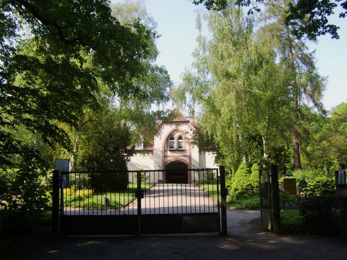
| Description | : | The official name is Friedhof Dotzheim but due to many of German cemeteries starting with Friedhof (cemetery), I used the city first to aid in locating. Dotzheim is a suburb of the city of Wiesbaden. The cemetery is also known as the Waldfriedhof. Address: Frauensteiner Strasse 65191 Wiesbaden-Dotzheim Established in 1905 Size: 57.800 qm May be reached by bus line 27 from downtown Wiesbaden, Stop: Waldfriedhof One will sometimes find a lack of old monuments in an old cemetery; this is caused by the German custom of reuse of a burial site. Burials are in wooden caskets, metal ones and in ground... Read More |
frequently asked questions (FAQ):
-
Where is Dotzheim Friedhof?
Dotzheim Friedhof is located at Frauensteiner Strasse Wiesbaden, Stadtkreis Wiesbaden ,Hessen , 65191Germany.
-
Dotzheim Friedhof cemetery's updated grave count on graveviews.com?
0 memorials
-
Where are the coordinates of the Dotzheim Friedhof?
Latitude: 50.0761300
Longitude: 8.1836900
Nearby Cemetories:
1. Wiesbaden-Schierstein
Schierstein, Stadtkreis Wiesbaden, Germany
Coordinate: 50.0461657, 8.1832950
2. Jüdischer Friedhof II
Schierstein, Stadtkreis Wiesbaden, Germany
Coordinate: 50.0457620, 8.1833030
3. Nordfriedhof Wiesbaden
Wiesbaden, Stadtkreis Wiesbaden, Germany
Coordinate: 50.0975140, 8.2204770
4. Alter Friedhof
Wiesbaden, Stadtkreis Wiesbaden, Germany
Coordinate: 50.0886490, 8.2308200
5. Alter jüdischer Friedhof
Schierstein, Stadtkreis Wiesbaden, Germany
Coordinate: 50.0443914, 8.1686029
6. Jüdischer Friedhof – Neue
Wiesbaden, Stadtkreis Wiesbaden, Germany
Coordinate: 50.1045900, 8.2154600
7. Friedhof an der Heidenmauer (Defunct)
Wiesbaden, Stadtkreis Wiesbaden, Germany
Coordinate: 50.0849600, 8.2382400
8. Jüdischer Friedhof – Orthodox
Wiesbaden, Stadtkreis Wiesbaden, Germany
Coordinate: 50.1053590, 8.2206060
9. Russischer Friedhof
Wiesbaden, Stadtkreis Wiesbaden, Germany
Coordinate: 50.0984600, 8.2362600
10. Jüdischer Friedhof
Wiesbaden, Stadtkreis Wiesbaden, Germany
Coordinate: 50.0889400, 8.2458900
11. Walluf War Memorial
Walluf, Rheingau-Taunus-Kreis, Germany
Coordinate: 50.0336440, 8.1615540
12. Friedhof St. Martin, Oberwalluf
Walluf, Rheingau-Taunus-Kreis, Germany
Coordinate: 50.0407536, 8.1394516
13. Friedhof Wiesbaden-Biebrich
Wiesbaden, Stadtkreis Wiesbaden, Germany
Coordinate: 50.0505110, 8.2500050
14. Waldfriedhof Mainz-Mombach
Mombach, Stadtkreis Mainz, Germany
Coordinate: 50.0205880, 8.1983990
15. Südfriedhof Wiesbaden
Wiesbaden, Stadtkreis Wiesbaden, Germany
Coordinate: 50.0589570, 8.2686710
16. Friedhof Sonnenberg
Wiesbaden, Stadtkreis Wiesbaden, Germany
Coordinate: 50.0986200, 8.2714100
17. Friedhof Bierstadt
Bierstadt, Stadtkreis Wiesbaden, Germany
Coordinate: 50.0865950, 8.2831690
18. Pfarrkirche St. Peter und Paul
Eltville, Rheingau-Taunus-Kreis, Germany
Coordinate: 50.0248110, 8.1212230
19. Katholische Pfarrkirche St. Valentinus und Dionys
Kiedrich, Rheingau-Taunus-Kreis, Germany
Coordinate: 50.0411670, 8.0847220
20. Wiesbaden-Kloppenheim
Wiesbaden, Stadtkreis Wiesbaden, Germany
Coordinate: 50.0921745, 8.3072090
21. Jüdischer Friedhof an der Mombacher Straße
Mainz, Stadtkreis Mainz, Germany
Coordinate: 50.0049700, 8.2516800
22. Friedhof Mainz-Kastel
Mainz-Kastel, Stadtkreis Wiesbaden, Germany
Coordinate: 50.0152200, 8.2833300
23. Hauptfriedhof Mainz
Mainz, Stadtkreis Mainz, Germany
Coordinate: 49.9951900, 8.2520200
24. Kloster Eberbach in Eltville am Rhein
Mainz, Stadtkreis Mainz, Germany
Coordinate: 50.0425000, 8.0466700