| Memorials | : | 4 |
| Location | : | Elliston, Powell County, USA |
| Coordinate | : | 46.5693090, -112.4406270 |
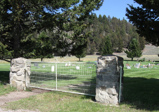
| Description | : | The Elliston Cemetery is the second cemetery located in Elliston, Montana. The first cemetery now called “Old Elliston Cemetery” was closed. “Elliston Cemetery” was opened with the first burial on April 3, 1924. The land having been donated by Delia and Felix Senecal. The Senecals were a young pioneer couple who years before had left their native state New York and headed west to Montana finally settling in Elliston. They owned land throughout the area including a parcel just west of town. It is said by the family that one day Delia realized Elliston needed a cemetery... Read More |
frequently asked questions (FAQ):
-
Where is Elliston Cemetery?
Elliston Cemetery is located at W. Old Mullan Trail Elliston, Powell County ,Montana ,USA.
-
Elliston Cemetery cemetery's updated grave count on graveviews.com?
4 memorials
-
Where are the coordinates of the Elliston Cemetery?
Latitude: 46.5693090
Longitude: -112.4406270
Nearby Cemetories:
1. Old Elliston Cemetery
Elliston, Powell County, USA
Coordinate: 46.5610000, -112.3983000
2. Avon Cemetery
Avon, Powell County, USA
Coordinate: 46.6111580, -112.6049040
3. Blackfoot City Cemetery
Avon, Powell County, USA
Coordinate: 46.6800000, -112.5520000
4. Marysville Cemetery
Lewis and Clark County, USA
Coordinate: 46.7566986, -112.2902985
5. Fort William Henry Harrison Cemetery
Helena, Lewis and Clark County, USA
Coordinate: 46.6227000, -112.1103000
6. Montana State Veterans Cemetery
Helena, Lewis and Clark County, USA
Coordinate: 46.6151886, -112.0993042
7. Montana Medal of Honor Grove
Helena, Lewis and Clark County, USA
Coordinate: 46.6227300, -112.0956300
8. Silver City Cemetery
Silver City, Lewis and Clark County, USA
Coordinate: 46.7360992, -112.1800003
9. John Montgomery Gravesite
Unionville, Lewis and Clark County, USA
Coordinate: 46.5170000, -112.0845000
10. Calvary Cemetery
Lewis and Clark County, USA
Coordinate: 46.5997009, -112.0714035
11. Home of Peace Cemetery
Helena, Lewis and Clark County, USA
Coordinate: 46.6152992, -112.0500031
12. Silver Creek Road Cemetery
Lewis and Clark County, USA
Coordinate: 46.6994500, -112.0916000
13. Saint Peters Episcopal Cathedral Columbarium
Helena, Lewis and Clark County, USA
Coordinate: 46.5925598, -112.0400925
14. Benton Avenue Cemetery
Helena, Lewis and Clark County, USA
Coordinate: 46.6045265, -112.0415497
15. Hillcrest Cemetery
Deer Lodge, Powell County, USA
Coordinate: 46.3958015, -112.7556000
16. City Cemetery (Defunct)
Helena, Lewis and Clark County, USA
Coordinate: 46.5896660, -112.0360010
17. Montana State Prison Cemetery
Deer Lodge, Powell County, USA
Coordinate: 46.3959999, -112.7590027
18. Cathedral of the Sacred Hearts of Jesus and Mary
Helena, Lewis and Clark County, USA
Coordinate: 46.5902550, -112.0339480
19. Lewis and Clark County Poor Farm Cemetery
Helena, Lewis and Clark County, USA
Coordinate: 46.6235460, -112.0383316
20. Old Catholic Cemetery
Helena, Lewis and Clark County, USA
Coordinate: 46.5779120, -112.0183220
21. Forestvale Cemetery
Helena, Lewis and Clark County, USA
Coordinate: 46.6563988, -112.0361023
22. IOOF Cemetery
Helena, Lewis and Clark County, USA
Coordinate: 46.6535873, -112.0311966
23. Lewis and Clark County Cemetery
Helena, Lewis and Clark County, USA
Coordinate: 46.6558870, -112.0319440
24. Plymouth Congregational Church Columbarium
Helena, Lewis and Clark County, USA
Coordinate: 46.5804000, -112.0109000

