
| Memorials | : | 0 |
| Location | : | Vlaardingen, Vlaardingen Municipality, Netherlands |
| Coordinate | : | 51.9172092, 4.3458557 |
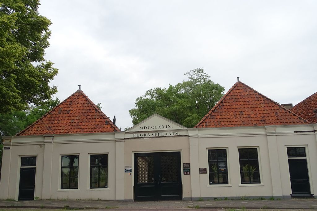
| Description | : | Vlaardingen is a town situated 12 kilometres west of Rotterdam and 25 kilometres south-south-east of The Hague. This cemetery is situated to the south of the A20 (the road from Hook of Holland to Rotterdam). From the A20 take exit 9 (afrit 9). At the end of the exit you turn left under the A20 to the Burgemeester Verkadesingel, then take the second road at your right (this is the Kethelweg). This road changes to Plein Emaus and then Emaus, and at the end of this road you will find the old general cemetery. |
frequently asked questions (FAQ):
-
Where is Emaus General Cemetery?
Emaus General Cemetery is located at Vlaardingen, Vlaardingen Municipality ,Zuid-Holland ,Netherlands.
-
Emaus General Cemetery cemetery's updated grave count on graveviews.com?
0 memorials
-
Where are the coordinates of the Emaus General Cemetery?
Latitude: 51.9172092
Longitude: 4.3458557
Nearby Cemetories:
1. Joodse Begraafplaats
Vlaardingen Municipality, Netherlands
Coordinate: 51.9096700, 4.3588700
2. Holy Begraafplaats
Vlaardingen, Vlaardingen Municipality, Netherlands
Coordinate: 51.9384700, 4.3380100
3. Begraafplaats Pernis
Pernis, Rotterdam Municipality, Netherlands
Coordinate: 51.8893400, 4.3809700
4. Sint Jacobus de Meerdere
Kethel, Schiedam Municipality, Netherlands
Coordinate: 51.9439015, 4.3871233
5. Begraafplaats Oudeland
Hoogvliet, Rotterdam Municipality, Netherlands
Coordinate: 51.8730895, 4.3670523
6. Rotterdam General Cemetery Hofwijk
Rotterdam, Rotterdam Municipality, Netherlands
Coordinate: 51.9574200, 4.3986700
7. Sint Petrus Banden Cemetery
Overschie, Rotterdam Municipality, Netherlands
Coordinate: 51.9412266, 4.4221499
8. Algemene Begraafplaats
Maassluis, Maassluis Municipality, Netherlands
Coordinate: 51.9162000, 4.2579500
9. Rozenburg General Cemetery
Rozenburg, Rotterdam Municipality, Netherlands
Coordinate: 51.9034500, 4.2513600
10. Joodse begraafplaats Delfshaven
Delfshaven, Rotterdam Municipality, Netherlands
Coordinate: 51.9060180, 4.4573698
11. Rooms-Katholieke Begraafplaats
Schipluiden, Midden-Delfland Municipality, Netherlands
Coordinate: 51.9865029, 4.3193462
12. De Lier Cemetery
De Lier, Westland Municipality, Netherlands
Coordinate: 51.9712106, 4.2550109
13. Joodse begraafplaats
Geervliet, Nissewaard Municipality, Netherlands
Coordinate: 51.8602530, 4.2556100
14. Protestant Church Cemetery
Heenvliet, Nissewaard Municipality, Netherlands
Coordinate: 51.8643528, 4.2439972
15. Begraafplaats Heenvliet
Heenvliet, Nissewaard Municipality, Netherlands
Coordinate: 51.8654244, 4.2359608
16. Delft Jaffa Cemetery
Delft, Delft Municipality, Netherlands
Coordinate: 52.0038500, 4.3724500
17. Joods begraafplaats Jan van Loonslaan
Rotterdam Municipality, Netherlands
Coordinate: 51.9252400, 4.4883000
18. Zwartewaal General Cemetery
Zwartewaal, Brielle Municipality, Netherlands
Coordinate: 51.8781800, 4.2135600
19. Begraafplaats Charlois
Charlois, Rotterdam Municipality, Netherlands
Coordinate: 51.8651000, 4.4678800
20. Rotterdam Crooswijk General Cemetery
Rotterdam, Rotterdam Municipality, Netherlands
Coordinate: 51.9393500, 4.4911600
21. Begraafplaats Sint Laurentius
Rotterdam, Rotterdam Municipality, Netherlands
Coordinate: 51.9342100, 4.4958500
22. Oude begraafplaats
Abbenbroek, Nissewaard Municipality, Netherlands
Coordinate: 51.8483566, 4.2408714
23. Nieuwe Kerk
Delft, Delft Municipality, Netherlands
Coordinate: 52.0122500, 4.3606780
24. Oude Kerk
Delft, Delft Municipality, Netherlands
Coordinate: 52.0126510, 4.3558930