
| Memorials | : | 9 |
| Location | : | Scotia, Greeley County, USA |
| Coordinate | : | 41.4663000, -98.6154000 |
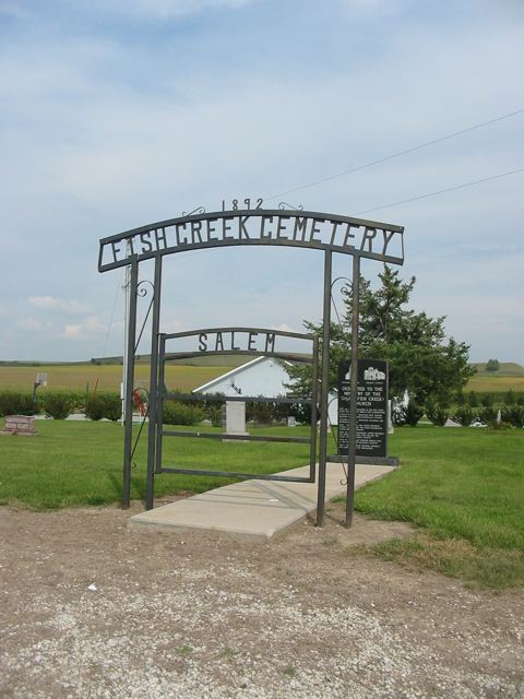
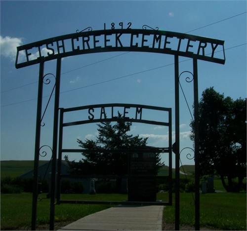
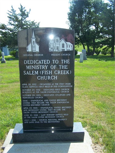
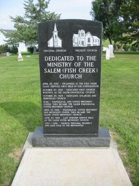
| Description | : | This cemetery is located just east of Scotia, Greeley county, NE on the north side of Highway 22. This cemetery is located on Highway 22, approximately four miles east of Scotia. At the entrance of the cemetery is a marker with this inscription: "Dedicated to the Ministry of the Salem (Fish Creek) Church. April 28, 1892 - Organized as the Fish Creek Class; Services first held in sod schoolhouse October 20, 1892 - Dedicated first church building as the Salem Evangelical ChurchOctober 20, 1929 - Dedicated, enlarged and remodeled church 1946 - Evangelical and United Brethren united then... Read More |
frequently asked questions (FAQ):
-
Where is Fish Creek Cemetery?
Fish Creek Cemetery is located at Scotia, Greeley County ,Nebraska ,USA.
-
Fish Creek Cemetery cemetery's updated grave count on graveviews.com?
9 memorials
-
Where are the coordinates of the Fish Creek Cemetery?
Latitude: 41.4663000
Longitude: -98.6154000
Nearby Cemetories:
1. Mount Hope Cemetery
Scotia, Greeley County, USA
Coordinate: 41.4752998, -98.7117004
2. Sacred Heart Cemetery
Greeley, Greeley County, USA
Coordinate: 41.5539017, -98.5381012
3. Greeley Cemetery
Greeley, Greeley County, USA
Coordinate: 41.5554000, -98.5400000
4. Swedish Cemetery
Greeley, Greeley County, USA
Coordinate: 41.5525017, -98.5147018
5. Summit Cemetery
Howard County, USA
Coordinate: 41.3875008, -98.4953003
6. O'Connor Cemetery
O'Connor, Greeley County, USA
Coordinate: 41.5101128, -98.4654999
7. East O'Connor Cemetery
O'Connor, Greeley County, USA
Coordinate: 41.5106000, -98.4638000
8. Cotesfield Cemetery
Cotesfield, Howard County, USA
Coordinate: 41.3358002, -98.6219025
9. Hillside Cemetery
North Loup, Valley County, USA
Coordinate: 41.4892006, -98.7960968
10. Fairdale Sunrise Cemetery
Elba, Howard County, USA
Coordinate: 41.3580000, -98.4887000
11. Pleasant Hill Cemetery
Belfast, Greeley County, USA
Coordinate: 41.6175003, -98.6352997
12. Dannevirke Cemetery
Dannevirke, Howard County, USA
Coordinate: 41.3227997, -98.6986008
13. North Logan Cemetery
Howard County, USA
Coordinate: 41.3657990, -98.4492035
14. Pleasant Hill Friends Cemetery
Valley County, USA
Coordinate: 41.4230800, -98.8377700
15. Saint Josephs Cemetery
Elba, Howard County, USA
Coordinate: 41.2930984, -98.5746994
16. Hillside Cemetery
Wolbach, Greeley County, USA
Coordinate: 41.4005089, -98.3921356
17. Fairdale Cemetery
Howard County, USA
Coordinate: 41.2891998, -98.5152969
18. Elba Cemetery
Elba, Howard County, USA
Coordinate: 41.2764015, -98.5643997
19. South Logan Cemetery
Howard County, USA
Coordinate: 41.3222100, -98.4352600
20. North Cemetery
Howard County, USA
Coordinate: 41.3222008, -98.4347000
21. Hamm Cemetery
Howard County, USA
Coordinate: 41.2933006, -98.4672012
22. Mount Carmel Cemetery
Howard County, USA
Coordinate: 41.2797012, -98.7328033
23. Springdale Hillside Cemetery
Valley County, USA
Coordinate: 41.6114010, -98.8282950
24. Bohemian National Graveyard
Howard County, USA
Coordinate: 41.2492070, -98.5927620