
| Memorials | : | 0 |
| Location | : | Polksville, Bath County, USA |
| Coordinate | : | 38.1303710, -83.6545370 |
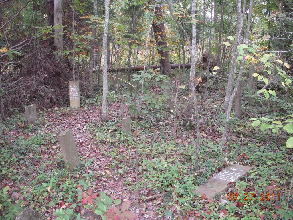
| Description | : | Flood Cemetery has also been referred to as the Flood-Clayton Cemetery and is located between and Salt Lick and Polksville on US 60. On US 60 driving west from Salt Lick, the cemetery is before Polksville. A landmark is Flood Hollow Road on the left where the Flood family lived for generations. At the next left, turn left onto Polksville Cemetery Road where there is a sign for Polksville Cemetery. The five cemeteries on this road are Maze Cemetery, Polksville Cemetery, Carpenter Cemetery, Flood Cemetery, and Montgomery Cemetery. Flood Cemetery has no sign but is immediately after Carpenter Cemetery. This cemetery is... Read More |
frequently asked questions (FAQ):
-
Where is Flood Cemetery?
Flood Cemetery is located at Polksville, Bath County ,Kentucky ,USA.
-
Flood Cemetery cemetery's updated grave count on graveviews.com?
0 memorials
-
Where are the coordinates of the Flood Cemetery?
Latitude: 38.1303710
Longitude: -83.6545370
Nearby Cemetories:
1. Carpenter Cemetery #1
Polksville, Bath County, USA
Coordinate: 38.1334200, -83.6496700
2. Polksville Cemetery
Bath County, USA
Coordinate: 38.1343040, -83.6498760
3. Barnes and Lewis Cemetery
Bath County, USA
Coordinate: 38.1276000, -83.6316200
4. Carpenter Cemetery #4
Bath County, USA
Coordinate: 38.1297500, -83.6778000
5. Carpenter Cemetery #3
Owingsville, Bath County, USA
Coordinate: 38.1297500, -83.6778000
6. Sorrell Homestead Cemetery
Owingsville, Bath County, USA
Coordinate: 38.1520740, -83.6590430
7. Rogers Cemetery
Owingsville, Bath County, USA
Coordinate: 38.1583990, -83.6657290
8. Hedricks Cemetery
Bath County, USA
Coordinate: 38.1609990, -83.6400910
9. Hedrick's Cemetery
Salt Lick, Bath County, USA
Coordinate: 38.1613803, -83.6408343
10. Knox Hill Cemetery
Peasticks, Bath County, USA
Coordinate: 38.1581001, -83.6781006
11. Lower Salt Lick Cemetery
Salt Lick, Bath County, USA
Coordinate: 38.1007900, -83.6242000
12. Dickerson Cemetery
Salt Lick, Bath County, USA
Coordinate: 38.1138992, -83.6091995
13. McCarty Cemetery
Owingsville, Bath County, USA
Coordinate: 38.1441994, -83.7033005
14. Norris Cemetery
Salt Lick, Bath County, USA
Coordinate: 38.0935980, -83.6168360
15. Reeves Cemetery
Colfax, Fleming County, USA
Coordinate: 38.1785480, -83.6456730
16. Crouch Family Cemetery
Salt Lick, Bath County, USA
Coordinate: 38.0875470, -83.6207480
17. Jackson Cemetery
Bath County, USA
Coordinate: 38.1239014, -83.7205963
18. Oldfield Cemetery
Owingsville, Bath County, USA
Coordinate: 38.1067009, -83.7155991
19. Mann Cemetery
Bath County, USA
Coordinate: 38.1067000, -83.7156000
20. Old Spencer Cemetery
Owingsville, Bath County, USA
Coordinate: 38.1382027, -83.7219543
21. McClain Cemetery
Salt Lick, Bath County, USA
Coordinate: 38.0856620, -83.6110320
22. Old Virginia Cemetery
Owingsville, Bath County, USA
Coordinate: 38.1721992, -83.7058029
23. Shrout Cemetery
Owingsville, Bath County, USA
Coordinate: 38.1180570, -83.7289850
24. Shrout Cemetery
Owingsville, Bath County, USA
Coordinate: 38.1178860, -83.7290780