
| Memorials | : | 0 |
| Location | : | Alamosa County, USA |
| Coordinate | : | 37.6136600, -105.5004480 |
| Description | : | The map location is approximate. |
frequently asked questions (FAQ):
-
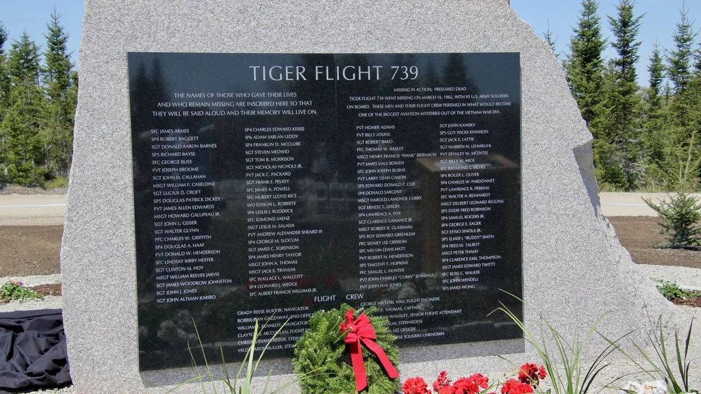
Where is Flying Tigers Crash Memorial?
Flying Tigers Crash Memorial is located at California Peak Alamosa County ,Colorado ,USA.
-
Flying Tigers Crash Memorial cemetery's updated grave count on graveviews.com?
0 memorials
-
Where are the coordinates of the Flying Tigers Crash Memorial?
Latitude: 37.6136600
Longitude: -105.5004480
Nearby Cemetories:
1. Uracca Pioneer Cemetery
Alamosa County, USA
Coordinate: 37.6021996, -105.5714035
2. Urraca Cemetery
Alamosa County, USA
Coordinate: 37.6898000, -105.5429000
3. Fort Massachusetts Post Cemetery
Costilla County, USA
Coordinate: 37.4953200, -105.3951900
4. Blanca Cemetery
Blanca, Costilla County, USA
Coordinate: 37.4542000, -105.5264000
5. Mac Mullan Cemetery
Blanca, Costilla County, USA
Coordinate: 37.4366989, -105.4646988
6. Myer Cemetery
Costilla County, USA
Coordinate: 37.4352810, -105.4501610
7. Blanca Trinchera Cemetery
Fort Garland, Costilla County, USA
Coordinate: 37.4302000, -105.4666000
8. Red Wing Cemetery
Red Wing, Huerfano County, USA
Coordinate: 37.7359886, -105.3088989
9. Brennaman Cemetery
Costilla County, USA
Coordinate: 37.4268990, -105.4274979
10. Chama Cemetery
Gardner, Huerfano County, USA
Coordinate: 37.7149390, -105.2890730
11. Gomez Cemetery
Red Wing, Huerfano County, USA
Coordinate: 37.7360000, -105.3050000
12. Fort Garland Post Cemetery
Fort Garland, Costilla County, USA
Coordinate: 37.4239700, -105.4323100
13. Fort Garland Cemetery
Fort Garland, Costilla County, USA
Coordinate: 37.4241982, -105.4272003
14. Gonzales Cemetery
Huerfano County, USA
Coordinate: 37.7341995, -105.2593994
15. Hoffman Cemetery
Fort Garland, Costilla County, USA
Coordinate: 37.3932689, -105.4030617
16. Gardner Cemetery
Gardner, Huerfano County, USA
Coordinate: 37.7827988, -105.1952972
17. Yellowstone Creek Cemetery
Farisita, Huerfano County, USA
Coordinate: 37.6714000, -105.1106000
18. Becker Cemetery
Alamosa County, USA
Coordinate: 37.3669014, -105.7478027
19. Sanches Cemetery
Huerfano County, USA
Coordinate: 37.6760000, -105.0984000
20. Oak View Cemetery
Huerfano County, USA
Coordinate: 37.5410995, -105.1010971
21. Alamosa Municipal Cemetery
Alamosa, Alamosa County, USA
Coordinate: 37.4495000, -105.8591000
22. Anderson Cemetery
Hooper, Alamosa County, USA
Coordinate: 37.7497010, -105.8805270
23. First United Methodist Church Columbarium
Alamosa, Alamosa County, USA
Coordinate: 37.4744000, -105.8855000
24. Gardner Catholic Cemetery
Gardner, Huerfano County, USA
Coordinate: 37.7645740, -105.1192200