
| Memorials | : | 0 |
| Location | : | Bridgwater, Sedgemoor District, England |
| Coordinate | : | 51.1261850, -3.0021850 |
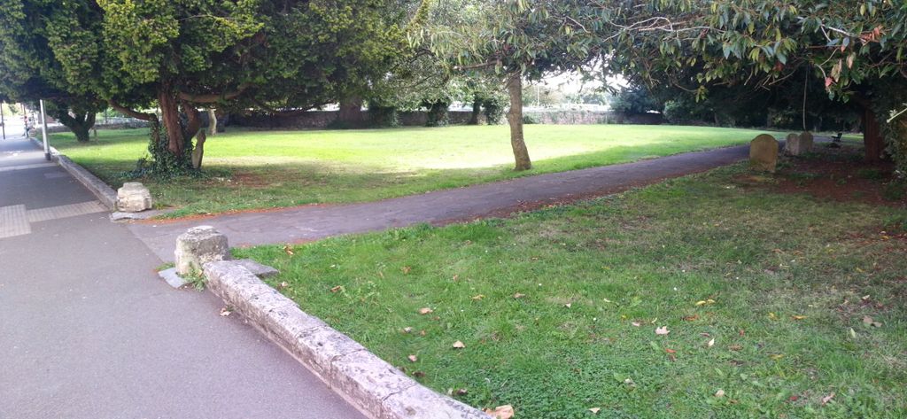
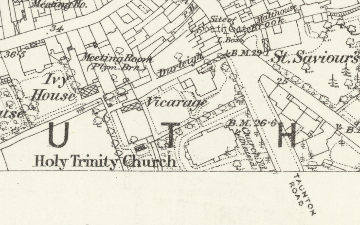
| Description | : | The church was consecrated in 1840 but demolished in 1958 and a modern church (also called Holy Trinity) was built in Hamp St. There is no sign or railings (these were removed) and little remains to identify the old site, except a low wall and a path around the perimeter. A related sunday school building still exists nearby (in St Saviour's Road) but is now used by a cycle workshop organisation. There are only a few extant headstones, though more graves may exist, unmarked. |
frequently asked questions (FAQ):
-
Where is Former Holy Trinity Churchyard?
Former Holy Trinity Churchyard is located at Taunton Road Bridgwater, Sedgemoor District ,Somerset , TA6 3LWEngland.
-
Former Holy Trinity Churchyard cemetery's updated grave count on graveviews.com?
0 memorials
-
Where are the coordinates of the Former Holy Trinity Churchyard?
Latitude: 51.1261850
Longitude: -3.0021850
Nearby Cemetories:
1. Bridgwater Baptist Church
Bridgwater, Sedgemoor District, England
Coordinate: 51.1272613, -3.0046282
2. St. Mary's Churchyard
Bridgwater, Sedgemoor District, England
Coordinate: 51.1277430, -3.0050330
3. Gray Friar's
Bridgwater, Sedgemoor District, England
Coordinate: 51.1264260, -3.0065160
4. Quaker Burial Ground
Bridgwater, Sedgemoor District, England
Coordinate: 51.1261740, -3.0078020
5. St John The Baptist Churchyard
Bridgwater, Sedgemoor District, England
Coordinate: 51.1311160, -2.9969910
6. Wembdon Road Cemetery
Bridgwater, Sedgemoor District, England
Coordinate: 51.1280877, -3.0138897
7. St George Churchyard
Wembdon, Sedgemoor District, England
Coordinate: 51.1364420, -3.0171170
8. St. John Bristol Road Cemetery
Bridgwater, Sedgemoor District, England
Coordinate: 51.1391470, -2.9901660
9. Quantock Road Cemetery
Bridgwater, Sedgemoor District, England
Coordinate: 51.1284270, -3.0285630
10. Holy Trinity Churchyard
Chilton Trinity, Sedgemoor District, England
Coordinate: 51.1474390, -3.0072360
11. St Hugh's Church
Durleigh, Sedgemoor District, England
Coordinate: 51.1198090, -3.0375260
12. Heathfield Cemetery
North Petherton, Sedgemoor District, England
Coordinate: 51.0957200, -3.0081100
13. St. Mary Parish Churchyard
North Petherton, Sedgemoor District, England
Coordinate: 51.0920790, -3.0149060
14. Church of the Blessed Virgin Mary Churchyard
Chedzoy, Sedgemoor District, England
Coordinate: 51.1344600, -2.9429400
15. St Edward King and Martyr Churchyard
Goathurst, Sedgemoor District, England
Coordinate: 51.1034930, -3.0633930
16. Blessed Virgin Mary Churchyard
Cannington, Sedgemoor District, England
Coordinate: 51.1500970, -3.0622850
17. Saint Michael & All Angels Churchyard
Bawdrip, Sedgemoor District, England
Coordinate: 51.1517260, -2.9429330
18. Westonzoyland Cemetery New
Westonzoyland, Sedgemoor District, England
Coordinate: 51.1096271, -2.9349336
19. Saint Michael and All Angels Churchyard
Puriton, Sedgemoor District, England
Coordinate: 51.1706000, -2.9735000
20. Cannington Cemetery
Cannington, Sedgemoor District, England
Coordinate: 51.1500620, -3.0697070
21. The Old Chapel
Westonzoyland, Sedgemoor District, England
Coordinate: 51.1077425, -2.9285237
22. St. Mary's Churchyard
Westonzoyland, Sedgemoor District, England
Coordinate: 51.1087000, -2.9273800
23. Westonzoyland Cemetery
Westonzoyland, Sedgemoor District, England
Coordinate: 51.1078900, -2.9264440
24. St. Peter's Churchyard
North Newton, Sedgemoor District, England
Coordinate: 51.0751380, -2.9990730