
| Memorials | : | 0 |
| Location | : | Luna County, USA |
| Coordinate | : | 32.4618988, -107.6391983 |
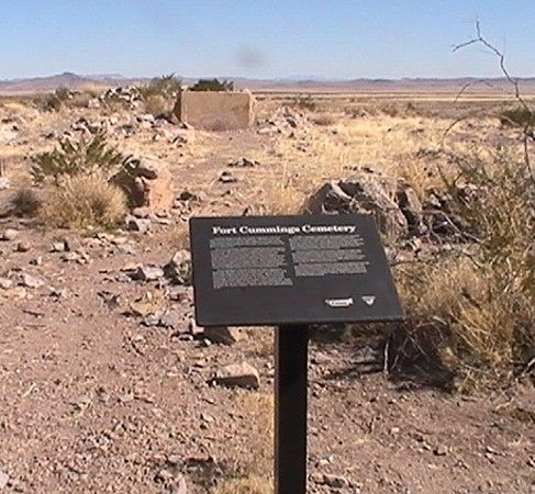
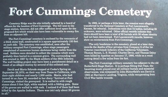
| Description | : | Cemetery Ridge was the site initially selected by a board of officers for the location of Fort Cummings. The hill next to the stage station, however, did not offer sufficient level space for the proposed fort which would also have been vulnerable to enemy fire from an adjacent hill. The Fort Cummings cemetery is enclosed by the remnants of a thick stone wall, constructed in a square approximately 150 feet on each side. The cemetery was established soon after the military occupied Fort Cummings when stage passengers complained of numerous human skeletons being visible from the road. Soldiers were detailed... Read More |
frequently asked questions (FAQ):
-
Where is Fort Cummings Cemetery?
Fort Cummings Cemetery is located at Luna County ,New Mexico ,USA.
-
Fort Cummings Cemetery cemetery's updated grave count on graveviews.com?
0 memorials
-
Where are the coordinates of the Fort Cummings Cemetery?
Latitude: 32.4618988
Longitude: -107.6391983
Nearby Cemetories:
1. Cooks Peak Cemetery
Luna County, USA
Coordinate: 32.5564003, -107.7181015
2. Desert Lawn Memorial Gardens
Deming, Luna County, USA
Coordinate: 32.3084000, -107.7818000
3. Mountain View Cemetery
Deming, Luna County, USA
Coordinate: 32.2677994, -107.7193985
4. Louise Coffman Memorial Park
Deming, Luna County, USA
Coordinate: 32.2524000, -107.7145000
5. Holy Cross Cemetery
Luna County, USA
Coordinate: 32.2789001, -107.8056030
6. Lewis Flats Cemetery
Deming, Luna County, USA
Coordinate: 32.2313995, -107.5710983
7. Foster Cemetery
Luna County, USA
Coordinate: 32.5862410, -107.9062660
8. Dwyer Cemetery
Dwyer, Grant County, USA
Coordinate: 32.6231600, -107.8792400
9. Lake Valley Cemetery
Lake Valley, Sierra County, USA
Coordinate: 32.7132988, -107.5640030
10. Nunn Ranch Cemetery
Sierra County, USA
Coordinate: 32.7410000, -107.6133000
11. Coleson's Crossing Cemetery
Dwyer, Grant County, USA
Coordinate: 32.5682540, -107.9522090
12. Perrault Ranch Cemetery
Sherman, Grant County, USA
Coordinate: 32.7493770, -107.8935000
13. Tierra Blanca Cemetery
Sierra County, USA
Coordinate: 32.8408000, -107.6540000
14. San Juan Catholic Cemetery
Grant County, USA
Coordinate: 32.7647705, -107.9098969
15. San Lorenzo Cemetery
San Lorenzo, Grant County, USA
Coordinate: 32.7910270, -107.9205040
16. Garden of Memories
Hatch, Doña Ana County, USA
Coordinate: 32.6539001, -107.1847000
17. Garfield Cemetery
Garfield, Doña Ana County, USA
Coordinate: 32.7576600, -107.2653200
18. Holy Cross Cemetery
Salem, Doña Ana County, USA
Coordinate: 32.7105000, -107.2090000
19. Placitas Hill Cemetery
Placitas, Doña Ana County, USA
Coordinate: 32.6646900, -107.1748700
20. Salem Cemetery
Doña Ana County, USA
Coordinate: 32.7104000, -107.2052000
21. Arrey Community Church Cemetery
Arrey, Sierra County, USA
Coordinate: 32.8132000, -107.3125000
22. Kingston Cemetery
Sierra County, USA
Coordinate: 32.9124985, -107.7061005
23. Hillsboro Cemetery
Hillsboro, Sierra County, USA
Coordinate: 32.9172000, -107.5667000
24. Carroll Cemetery
Luna County, USA
Coordinate: 32.0522003, -107.8855972