
| Memorials | : | 0 |
| Location | : | Tensaw, Baldwin County, USA |
| Coordinate | : | 31.1781100, -87.8380100 |
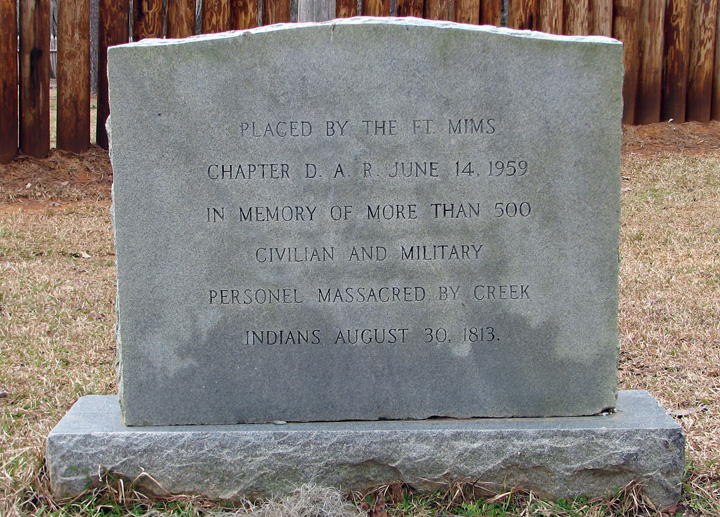
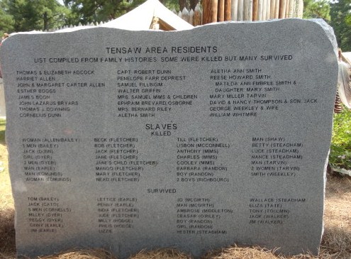
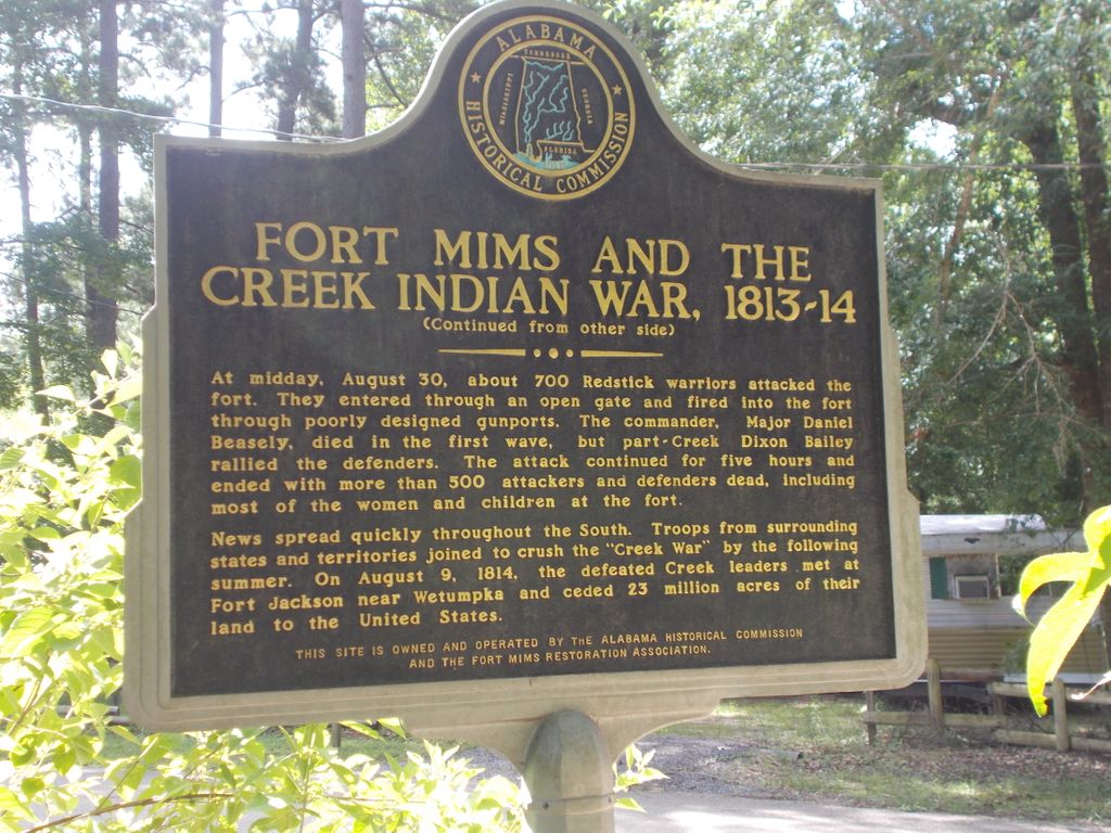
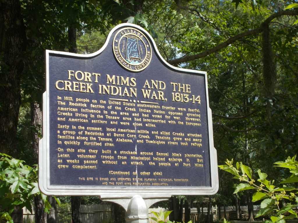
| Description | : | The Fort Mims massacre was a battle that occurred on 30 August 1813 during the Creek War, when a force of Creek Indians, belonging to the "Red Sticks" faction under the command of head warriors Peter McQueen and William Weatherford, or Lamochattee (Red Eagle), stormed the fort and defeated the militia garrison. After the defeat of the garrison there ensued a massacre and almost all of the remaining Lower Creek, white settlers, and militia at Fort Mims were killed. The fort was a stockade with a blockhouse surrounding the house and outbuildings of the settler Samuel Mims, located about 35... Read More |
frequently asked questions (FAQ):
-
Where is Fort Mims Burial Ground?
Fort Mims Burial Ground is located at Tensaw, Baldwin County ,Alabama ,USA.
-
Fort Mims Burial Ground cemetery's updated grave count on graveviews.com?
0 memorials
-
Where are the coordinates of the Fort Mims Burial Ground?
Latitude: 31.1781100
Longitude: -87.8380100
Nearby Cemetories:
1. Tensaw Memorial Cemetery
Tensaw, Baldwin County, USA
Coordinate: 31.1977997, -87.7944031
2. Montgomery Hill Cemetery
Montgomery Hill, Baldwin County, USA
Coordinate: 31.1634960, -87.7864685
3. Mount Nebo Baptists Church Cemetery
Stockton, Baldwin County, USA
Coordinate: 31.1290300, -87.8346800
4. Latham Methodist Church Cemetery
Latham, Baldwin County, USA
Coordinate: 31.0983658, -87.8300323
5. Wilson Family Cemetery
Little River, Baldwin County, USA
Coordinate: 31.2111588, -87.7379303
6. Blake Place
Montgomery Hill, Baldwin County, USA
Coordinate: 31.2180800, -87.7397100
7. Tate Cemetery
Baldwin County, USA
Coordinate: 31.2450008, -87.7611008
8. Steadham Cemetery
Baldwin County, USA
Coordinate: 31.2406006, -87.7455978
9. Lee Slaughter Family Cemetery
Baldwin County, USA
Coordinate: 31.2189121, -87.7233658
10. Tate Tunstall Family Cemetery
Blacksher, Baldwin County, USA
Coordinate: 31.2121830, -87.7194824
11. Bryars Family Cemetery
Stockton, Baldwin County, USA
Coordinate: 31.0665500, -87.8397100
12. William Weatherford Memorial Park
Little River, Baldwin County, USA
Coordinate: 31.2782993, -87.7675018
13. Big John Missionary Baptist Church Cemetery
Washington County, USA
Coordinate: 31.2082996, -87.9732971
14. Lancaster Cemetery
Baldwin County, USA
Coordinate: 31.0426120, -87.8494800
15. Robinson Cemetery
Stockton, Baldwin County, USA
Coordinate: 31.0402000, -87.8555000
16. Malcolm Cemetery
Malcolm, Washington County, USA
Coordinate: 31.1958008, -88.0049973
17. Big John Baptist Church Cemetery
Malcolm, Washington County, USA
Coordinate: 31.1911164, -88.0077110
18. Watson Family Cemetery
Baldwin County, USA
Coordinate: 31.0301369, -87.8390816
19. Vaughn Cemetery
Vaughn, Baldwin County, USA
Coordinate: 31.0312010, -87.8609040
20. Scott Field
Clarke County, USA
Coordinate: 31.3266200, -87.8331200
21. Mamies Chapel Cemetery
Little River, Baldwin County, USA
Coordinate: 31.2830009, -87.7134018
22. Calvert Cemetery
Malcolm, Washington County, USA
Coordinate: 31.1553001, -88.0108032
23. Phillips Family Cemetery
Little River, Baldwin County, USA
Coordinate: 31.2761993, -87.7026901
24. Shipp Cemetery
Little River, Baldwin County, USA
Coordinate: 31.2973995, -87.7204971