
| Memorials | : | 0 |
| Location | : | White Bird, Idaho County, USA |
| Coordinate | : | 45.7421000, -116.3233000 |
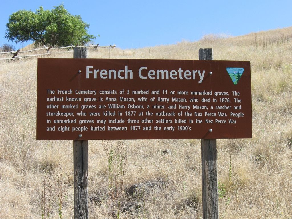
| Description | : | This cemetery sits on the east side of the old Highway 95, about 1 1/2 miles south of Whitebird, on the hill above the bridge that crosses the river on the way to Hammer Creek. The sign states that there are 3 marked graves and 11 or more unmarked. The earliest is Anna Mason. Three of the eleven or more unmarked burials were killed by the Indians, eight of the unmarked burials are deaths from 1877 to 1900. The sign is beside the old highway. BATTLES OF THE NEZ PERCE WAR OF 1877 This war pitted the non-Treaty Nez... Read More |
frequently asked questions (FAQ):
-
Where is French Cemetery?
French Cemetery is located at White Bird, Idaho County ,Idaho ,USA.
-
French Cemetery cemetery's updated grave count on graveviews.com?
0 memorials
-
Where are the coordinates of the French Cemetery?
Latitude: 45.7421000
Longitude: -116.3233000
Nearby Cemetories:
1. White Bird Cemetery
White Bird, Idaho County, USA
Coordinate: 45.7477989, -116.3116989
2. Canfield Cemetery
Idaho County, USA
Coordinate: 45.8369000, -116.3695000
3. Slate Creek Cemetery
Slate Creek, Idaho County, USA
Coordinate: 45.6354500, -116.2792400
4. Joseph Cemetery
Idaho County, USA
Coordinate: 45.7975006, -116.4633026
5. Dr Wilson A Fosskett Cemetery
Riggins, Idaho County, USA
Coordinate: 45.6299260, -116.2873060
6. John Day Cemetery
Riggins, Idaho County, USA
Coordinate: 45.5849000, -116.2885000
7. Kirkwood Bar Burial Site
Lucile, Idaho County, USA
Coordinate: 45.5679700, -116.4978500
8. Mount Idaho Cemetery
Mount Idaho, Idaho County, USA
Coordinate: 45.9040000, -116.0723000
9. Prairie View Cemetery
Grangeville, Idaho County, USA
Coordinate: 45.9308205, -116.1129837
10. Hillcrest Cemetery
Grangeville, Idaho County, USA
Coordinate: 45.9283860, -116.0824710
11. Denver Cemetery
Denver, Idaho County, USA
Coordinate: 46.0088997, -116.2225037
12. William Foster Cemetery
Cottonwood, Idaho County, USA
Coordinate: 46.0264430, -116.3276560
13. Fairview Cemetery
Grangeville, Idaho County, USA
Coordinate: 45.9759000, -116.0677000
14. Saint Gertrudes Monastery Cemetery
Cottonwood, Idaho County, USA
Coordinate: 46.0335000, -116.3951000
15. Monastery of Saint Gertrude Cemetery
Cottonwood, Idaho County, USA
Coordinate: 46.0335170, -116.3951490
16. Keuterville Community Cemetery
Keuterville, Idaho County, USA
Coordinate: 46.0346000, -116.4312000
17. Florence Cemetery
Idaho County, USA
Coordinate: 45.5107994, -116.0297012
18. Riggins Cemetery
Riggins, Idaho County, USA
Coordinate: 45.4291992, -116.3139038
19. Cottonwood Community Cemetery
Cottonwood, Idaho County, USA
Coordinate: 46.0630989, -116.3463974
20. Saint Mary's Catholic Cemetery
Cottonwood, Idaho County, USA
Coordinate: 46.0637000, -116.3478000
21. Harpster Cemetery
Harpster, Idaho County, USA
Coordinate: 45.9927000, -115.9632000
22. Greencreek Cemetery
Greencreek, Idaho County, USA
Coordinate: 46.1000000, -116.2544000
23. E A Parisot Cemetery
Florence, Idaho County, USA
Coordinate: 45.4671189, -115.9815195
24. Wind River Pack Bridge Burial Site
Riggins, Idaho County, USA
Coordinate: 45.4553700, -115.9447500