| Memorials | : | 0 |
| Location | : | Amorbach, Landkreis Miltenberg, Germany |
| Coordinate | : | 49.6584208, 9.2804977 |
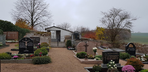
| Description | : | Reichartshausen is a small village, since 1976 part of the town of Amorbach in Bavaria. The small cemetery surrounds the St. Mauritius Village Church, dating back to 1716. There is another cemetery in Amorbach, located in Amorbach-Beuchen. Please note that the graves in Germany are not perpetual. After a certain period of repose (25 years for the cemeteries in Amorbach) the graves are being leveled and re-used. There is no toxic embalming being done in Germany, so the coffin and the corpse can decompose naturally. If the family of the deceased decides to purchase another period the duration can be extended... Read More |
frequently asked questions (FAQ):
-
Where is Friedhof Amorbach-Reichartshausen?
Friedhof Amorbach-Reichartshausen is located at Reichartshausen Amorbach, Landkreis Miltenberg ,Bavaria (Bayern) , 63916Germany.
-
Friedhof Amorbach-Reichartshausen cemetery's updated grave count on graveviews.com?
0 memorials
-
Where are the coordinates of the Friedhof Amorbach-Reichartshausen?
Latitude: 49.6584208
Longitude: 9.2804977
Nearby Cemetories:
1. Old Jewish Cemetery
Miltenberg, Landkreis Miltenberg, Germany
Coordinate: 49.7045200, 9.2672500
2. Friedhof Buch
Kirchzell, Landkreis Miltenberg, Germany
Coordinate: 49.6143390, 9.2001860
3. Kloster Engelberg in Grossheubach
Grossheubach, Landkreis Miltenberg, Germany
Coordinate: 49.7238890, 9.2319440
4. Friedhof Walldürn
Walldürn, Neckar-Odenwald-Kreis, Germany
Coordinate: 49.5890290, 9.3611526
5. Jüdischer Friedhof Bad König
Bad König, Odenwaldkreis, Germany
Coordinate: 49.7449500, 9.3471000
6. Friedhof Watterbach
Watterbach, Landkreis Miltenberg, Germany
Coordinate: 49.6271500, 9.1341200
7. Dorffriedhof Stürzenhardt
Buchen, Neckar-Odenwald-Kreis, Germany
Coordinate: 49.5537049, 9.2693585
8. Friedhof Laudenbach
Laudenbach, Landkreis Miltenberg, Germany
Coordinate: 49.7421300, 9.1783800
9. Sonderriet Friedhof
Sonderriet, Main-Tauber-Kreis, Germany
Coordinate: 49.7189840, 9.4390620
10. Friedhof Breitenbuch
Kirchzell, Landkreis Miltenberg, Germany
Coordinate: 49.6178530, 9.1044980
11. Friedhof Mudau
Mudau, Neckar-Odenwald-Kreis, Germany
Coordinate: 49.5410400, 9.3330530
12. Friedhof Mönchberg
Mönchberg, Landkreis Miltenberg, Germany
Coordinate: 49.7831300, 9.2387600
13. Friedhof Vielbrunn
Vielbrunn, Odenwaldkreis, Germany
Coordinate: 49.7097000, 9.0977200
14. Steinfurt Friedhof
Steinfurt, Main-Tauber-Kreis, Germany
Coordinate: 49.6470210, 9.4843450
15. Friedhof Klingenberg am Main
Klingenberg am Main, Landkreis Miltenberg, Germany
Coordinate: 49.7769190, 9.1847170
16. Saint Alban Catholic Church Cemetery
Hardheim, Neckar-Odenwald-Kreis, Germany
Coordinate: 49.6087700, 9.4745800
17. Nassig Friedhof
Nassig, Main-Tauber-Kreis, Germany
Coordinate: 49.7378280, 9.4496690
18. Friedhof Buchen
Buchen, Neckar-Odenwald-Kreis, Germany
Coordinate: 49.5256080, 9.3214510
19. Schloss Waldleiningen
Mudau, Neckar-Odenwald-Kreis, Germany
Coordinate: 49.5670600, 9.1170300
20. Friedhof Hettingen
Neckarzimmern, Neckar-Odenwald-Kreis, Germany
Coordinate: 49.5194500, 9.3687600
21. Friedhof Bretzingen
Bretzingen, Neckar-Odenwald-Kreis, Germany
Coordinate: 49.5799045, 9.4843562
22. RuheForst Südspessart Stadtprozelten
Stadtprozelten, Landkreis Miltenberg, Germany
Coordinate: 49.7870383, 9.4156397
23. Sachsenhausen Nordfriedhof
Sachsenhausen, Main-Tauber-Kreis, Germany
Coordinate: 49.7329959, 9.4917324
24. Friedhof Wörth am Main
Wörth am Main, Landkreis Miltenberg, Germany
Coordinate: 49.7987430, 9.1496900

