
| Memorials | : | 0 |
| Location | : | Koldenbüttel, Kreis Nordfriesland, Germany |
| Coordinate | : | 54.3878400, 9.0670600 |
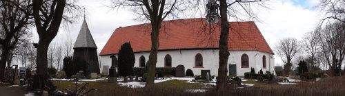
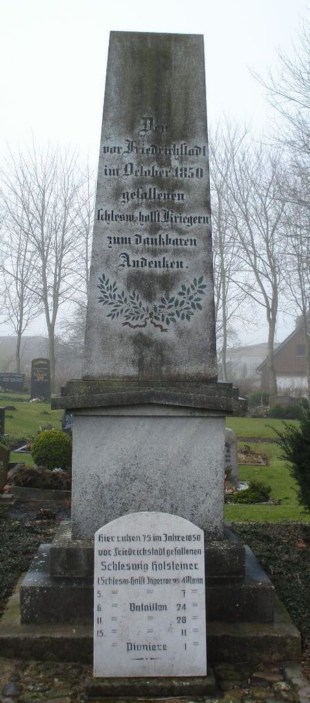
| Description | : | Koldenbüttel lies in the Eider Treene-Losiny about 8 miles south of Husum and just west of Friedrichstadt at the confluence of the Eider and the Treene in the Marsh. In 2013 it had about 900 inhabitants. The St. Leonhardt's church was built around the year 1200 by Frisian immigrants, which were settling at Eiderstedt around 1100. The current building was erected in the 16th century. The free standing wooden bell tower even before that. The church is surrounded by the village cemetery. Some historic grave markers are kept at the "Lapidarium," the actual grave site is lost, but the markers are... Read More |
frequently asked questions (FAQ):
-
Where is Friedhof Koldenbüttel?
Friedhof Koldenbüttel is located at Dorfstrasse Koldenbüttel, Kreis Nordfriesland ,Schleswig-Holstein , 25840Germany.
-
Friedhof Koldenbüttel cemetery's updated grave count on graveviews.com?
0 memorials
-
Where are the coordinates of the Friedhof Koldenbüttel?
Latitude: 54.3878400
Longitude: 9.0670600
Nearby Cemetories:
1. Kirchengemeinde Mildstedt
Mildstedt, Kreis Nordfriesland, Germany
Coordinate: 54.4617499, 9.0987751
2. Südfriedhof Husum
Husum, Kreis Nordfriesland, Germany
Coordinate: 54.4653159, 9.0784516
3. Saint Jürgen Friedhof
Husum, Landkreis Nienburg, Germany
Coordinate: 54.4786824, 9.0581862
4. Westfriedhof Husum
Husum, Kreis Nordfriesland, Germany
Coordinate: 54.4790950, 9.0450433
5. Ostfriedhof Husum
Husum, Kreis Nordfriesland, Germany
Coordinate: 54.4814540, 9.0710590
6. Historischer St. Jürgen Friedhof
Husum, Kreis Nordfriesland, Germany
Coordinate: 54.4858000, 9.0523900
7. Friedhof Tönning
Tönning, Kreis Nordfriesland, Germany
Coordinate: 54.3199596, 8.9376704
8. Friedhof Schwesing
Schwesing, Kreis Nordfriesland, Germany
Coordinate: 54.4951183, 9.1349389
9. St. Marien Kirche Friedhof
Hattstedt, Kreis Nordfriesland, Germany
Coordinate: 54.5251480, 9.0205530
10. Gemeindefriedhof
Tetenbull, Kreis Nordfriesland, Germany
Coordinate: 54.3533819, 8.8324241
11. Erfde Cemetery
Erfde, Kreis Schleswig-Flensburg, Germany
Coordinate: 54.3082940, 9.3067200
12. St. Martin Vollerwiek
Vollerwiek, Kreis Nordfriesland, Germany
Coordinate: 54.2911793, 8.7949694
13. Nordfriedhof Heide (Altar Friedhof)
Heide, Kreis Dithmarschen, Germany
Coordinate: 54.1993266, 9.0960977
14. Südfriedhof Heide
Heide, Kreis Dithmarschen, Germany
Coordinate: 54.1840233, 9.0833694
15. Friedhof Bredstedt
Bredstedt, Kreis Nordfriesland, Germany
Coordinate: 54.6153270, 8.9655360
16. St. Nikolai zu Bordelum
Bordelum, Kreis Nordfriesland, Germany
Coordinate: 54.6383240, 8.9411910
17. Friedhof Kropp
Kropp, Kreis Schleswig-Flensburg, Germany
Coordinate: 54.4112940, 9.5149380
18. Friedhof Albersdorf
Albersdorf, Kreis Dithmarschen, Germany
Coordinate: 54.1486720, 9.2813910
19. Friedhof der Evangelischen Kirche St. Nikolai
Sankt Peter-Ording, Kreis Nordfriesland, Germany
Coordinate: 54.3357720, 8.6070420
20. Büsum Friedhof
Busum, Kreis Dithmarschen, Germany
Coordinate: 54.1363188, 8.8660572
21. Friedhof Eggebek
Eggebek, Kreis Schleswig-Flensburg, Germany
Coordinate: 54.6188797, 9.3785172
22. Meldorfer Friedhof Dithmarschen
Meldorf, Kreis Dithmarschen, Germany
Coordinate: 54.0931100, 9.0747300
23. Gottorf Palace
Schleswig, Kreis Schleswig-Flensburg, Germany
Coordinate: 54.5118080, 9.5410680
24. Neuer Garnisonfriedhof
Schleswig, Kreis Schleswig-Flensburg, Germany
Coordinate: 54.5239000, 9.5366000