
| Memorials | : | 1 |
| Location | : | Weener, Landkreis Leer, Germany |
| Coordinate | : | 53.1348100, 7.3221570 |
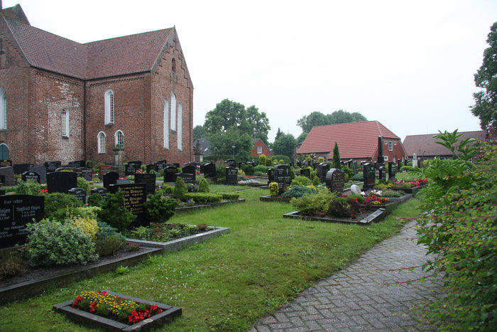
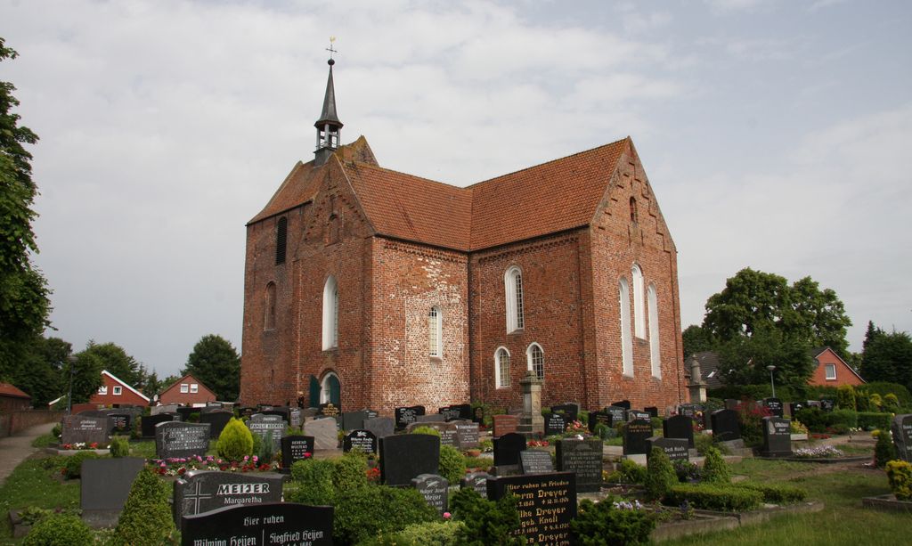
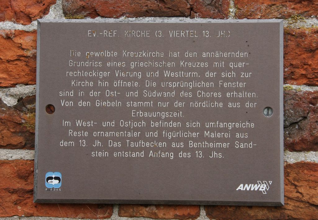
| Description | : | The Cross Church in Stapelmoor is one of the oldest churches in Ostfriesland. Stapelmoor was a separate village prior to 1974 when it merged with Stapelmoorerheide, Diele and a few other villages and are now part of the municipality of Weener, Landkreis Leer. The church was built in the third quarter of the 13th century. The parsonage was built in 1429 and is one of the oldest continuously inhabited parish houses in Germany. There are two sections of cemetery. The main cemetery that surrounds the church building, the other across the back alley surrounded by a tall hedge line. NOTE: ... Read More |
frequently asked questions (FAQ):
-
Where is Friedhof Stapelmoor?
Friedhof Stapelmoor is located at Grosse Stiege 1 / Stapelmoor Weener, Landkreis Leer ,Lower Saxony (Niedersachsen) , 26826Germany.
-
Friedhof Stapelmoor cemetery's updated grave count on graveviews.com?
1 memorials
-
Where are the coordinates of the Friedhof Stapelmoor?
Latitude: 53.1348100
Longitude: 7.3221570
Nearby Cemetories:
1. Friedhof Holthusen
Holthusen, Landkreis Leer, Germany
Coordinate: 53.1501900, 7.3175650
2. Friedhof Vellage
Weener, Landkreis Leer, Germany
Coordinate: 53.1155510, 7.3400310
3. Friedhof Mitling-Mark
Westoverledingen, Landkreis Leer, Germany
Coordinate: 53.1325110, 7.3785670
4. Alter Friedhof Weener
Weener, Landkreis Leer, Germany
Coordinate: 53.1655418, 7.3565815
5. Friedhof Möhlenwarf
Weener, Landkreis Leer, Germany
Coordinate: 53.1761196, 7.3040002
6. Friedhof Völlen
Westoverledingen, Landkreis Leer, Germany
Coordinate: 53.1089930, 7.3850390
7. Friedhof Wymeer
Bunde, Landkreis Leer, Germany
Coordinate: 53.1349470, 7.2400330
8. Jüdischer Friedhof
Bunde, Landkreis Leer, Germany
Coordinate: 53.1817170, 7.2736690
9. Alter Friedhof Bunde
Bunde, Landkreis Leer, Germany
Coordinate: 53.1849400, 7.2689840
10. Neuer Friedhof Bunde
Bunde, Landkreis Leer, Germany
Coordinate: 53.1849400, 7.2689840
11. Friedhof Grotegaste
Westoverledingen, Landkreis Leer, Germany
Coordinate: 53.1731640, 7.3988520
12. Friedhof Weenermoor
Weener, Landkreis Leer, Germany
Coordinate: 53.1951651, 7.3228192
13. Jüdischer Friedhof (Aschendorf)
Papenburg, Landkreis Emsland, Germany
Coordinate: 53.0705809, 7.3192885
14. Friedhof Völlenerfehn
Westoverledingen, Landkreis Leer, Germany
Coordinate: 53.1020220, 7.4181880
15. Friedhof Steenfelde
Steenfelde, Landkreis Leer, Germany
Coordinate: 53.1378900, 7.4395380
16. Friedhof Papenburg
Papenburg, Landkreis Emsland, Germany
Coordinate: 53.0804783, 7.3987984
17. Friedhof Grosswolde
Westoverledingen, Landkreis Leer, Germany
Coordinate: 53.1431660, 7.4450360
18. Nieuweschans General Cemetery
Nieuweschans, Oldambt Municipality, Netherlands
Coordinate: 53.1798800, 7.2142900
19. Joodse Begraafplaats
Nieuweschans, Oldambt Municipality, Netherlands
Coordinate: 53.1791800, 7.2124000
20. Friedhof Sankt Georgiwold
Weener, Landkreis Leer, Germany
Coordinate: 53.2151970, 7.3208000
21. Nieuweschans Old Cemetery
Nieuweschans, Oldambt Municipality, Netherlands
Coordinate: 53.1786100, 7.2090600
22. Kath. Friedhof Aschendorf
Aschendorf, Landkreis Emsland, Germany
Coordinate: 53.0540548, 7.3278482
23. Friedhof Kirchborgum
Weener, Landkreis Leer, Germany
Coordinate: 53.2002893, 7.4044874
24. Friedhof Driever
Westoverledingen, Landkreis Leer, Germany
Coordinate: 53.1944670, 7.4189670