
| Memorials | : | 0 |
| Location | : | Weener, Landkreis Leer, Germany |
| Coordinate | : | 53.1155510, 7.3400310 |
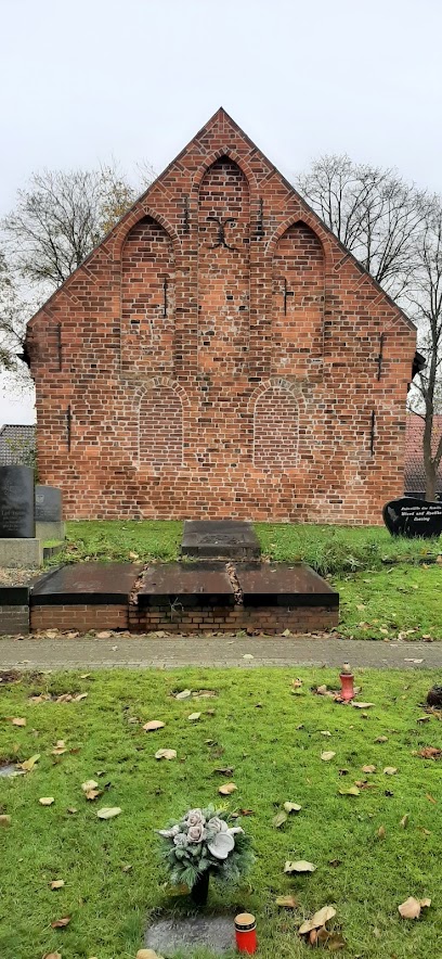
| Description | : | This old Lutheran cemetery and the church within date back to the 13th century. It's located on an artificial hill, built by the people of Vellage 600 years ago in an area prone to flooding. The cemetery has several War Memorials with the names and sometimes dates of soldiers from this town, who died during the wars of the past two centuries. Most of them are missing in action and their bodies have never been found and returned to their families. They are not buried here, but remembered on these war memorial plaques and monuments. Please note that the graves in Germany... Read More |
frequently asked questions (FAQ):
-
Where is Friedhof Vellage?
Friedhof Vellage is located at Villdobben Weener, Landkreis Leer ,Lower Saxony (Niedersachsen) , 26826Germany.
-
Friedhof Vellage cemetery's updated grave count on graveviews.com?
0 memorials
-
Where are the coordinates of the Friedhof Vellage?
Latitude: 53.1155510
Longitude: 7.3400310
Nearby Cemetories:
1. Friedhof Stapelmoor
Weener, Landkreis Leer, Germany
Coordinate: 53.1348100, 7.3221570
2. Friedhof Völlen
Westoverledingen, Landkreis Leer, Germany
Coordinate: 53.1089930, 7.3850390
3. Friedhof Mitling-Mark
Westoverledingen, Landkreis Leer, Germany
Coordinate: 53.1325110, 7.3785670
4. Friedhof Holthusen
Holthusen, Landkreis Leer, Germany
Coordinate: 53.1501900, 7.3175650
5. Jüdischer Friedhof (Aschendorf)
Papenburg, Landkreis Emsland, Germany
Coordinate: 53.0705809, 7.3192885
6. Friedhof Völlenerfehn
Westoverledingen, Landkreis Leer, Germany
Coordinate: 53.1020220, 7.4181880
7. Friedhof Papenburg
Papenburg, Landkreis Emsland, Germany
Coordinate: 53.0804783, 7.3987984
8. Alter Friedhof Weener
Weener, Landkreis Leer, Germany
Coordinate: 53.1655418, 7.3565815
9. Kath. Friedhof Aschendorf
Aschendorf, Landkreis Emsland, Germany
Coordinate: 53.0540548, 7.3278482
10. Friedhof Wymeer
Bunde, Landkreis Leer, Germany
Coordinate: 53.1349470, 7.2400330
11. Friedhof Steenfelde
Steenfelde, Landkreis Leer, Germany
Coordinate: 53.1378900, 7.4395380
12. Friedhof Möhlenwarf
Weener, Landkreis Leer, Germany
Coordinate: 53.1761196, 7.3040002
13. Friedhof Grotegaste
Westoverledingen, Landkreis Leer, Germany
Coordinate: 53.1731640, 7.3988520
14. Friedhof Völlenerkönigsfehn
Westoverledingen, Landkreis Leer, Germany
Coordinate: 53.1000300, 7.4504200
15. Friedhof Grosswolde
Westoverledingen, Landkreis Leer, Germany
Coordinate: 53.1431660, 7.4450360
16. Katholischer Friedhof Flachsmeer
Westoverledingen, Landkreis Leer, Germany
Coordinate: 53.1189533, 7.4608385
17. Evangelisch-lutherischer Friedhof Flachsmeer
Westoverledingen, Landkreis Leer, Germany
Coordinate: 53.1233800, 7.4627760
18. Jüdischer Friedhof
Bunde, Landkreis Leer, Germany
Coordinate: 53.1817170, 7.2736690
19. Friedhof Grosswolderfeld
Westoverledingen, Landkreis Leer, Germany
Coordinate: 53.1320270, 7.4678850
20. Friedhof Weenermoor
Weener, Landkreis Leer, Germany
Coordinate: 53.1951651, 7.3228192
21. Alter Friedhof Bunde
Bunde, Landkreis Leer, Germany
Coordinate: 53.1849400, 7.2689840
22. Neuer Friedhof Bunde
Bunde, Landkreis Leer, Germany
Coordinate: 53.1849400, 7.2689840
23. Friedhof Ihrhove
Westoverledingen, Landkreis Leer, Germany
Coordinate: 53.1619890, 7.4590140
24. Gemeindefriedhof Ihrenerfeld
Westoverledingen, Landkreis Leer, Germany
Coordinate: 53.1441510, 7.4739760