
| Memorials | : | 0 |
| Location | : | Fürstenfeldbruck, Landkreis Fürstenfeldbruck, Germany |
| Coordinate | : | 48.1090775, 11.0842724 |
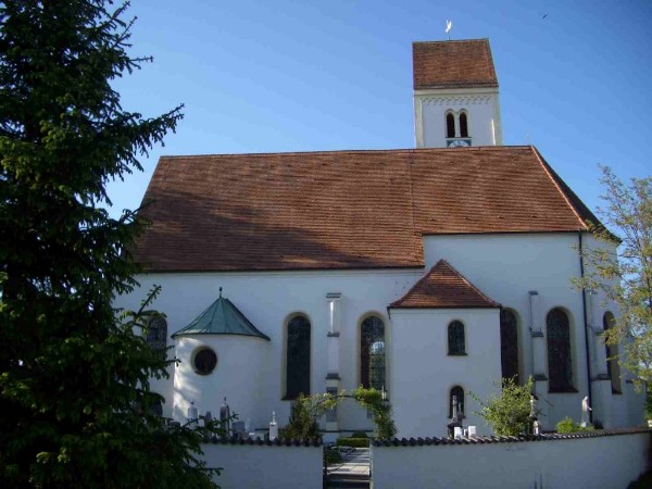
| Description | : | Address: Bahnhofstrasse 82299 Türkenfeld GERMANY Türkenfeld is a small village in the county of Fürstenfeldbruck with about 3500 inhabitants (as of 2006). It lies about 20 miles West of Munich. This old Catholic cemetery surrounds the Church of the Assumption of the Blessed Virgin Mary (Pfarrkirche Mariä Himmelfahrt). There is a newer part of the cemetery directly to the North of this church yard. Both are called Friedhof Türkenfeld. The church itself dates back to 1489. Multiple expansions and renovations took place over the next centuries. The current structure was completed in 1889. As often in Germany the cemetery and the church/chapel within have... Read More |
frequently asked questions (FAQ):
-
Where is Friedhof Türkenfeld?
Friedhof Türkenfeld is located at KreisFürstenfeldbruck Fürstenfeldbruck, Landkreis Fürstenfeldbruck ,Bavaria (Bayern) ,Germany.
-
Friedhof Türkenfeld cemetery's updated grave count on graveviews.com?
0 memorials
-
Where are the coordinates of the Friedhof Türkenfeld?
Latitude: 48.1090775
Longitude: 11.0842724
Nearby Cemetories:
1. Jüdische Friedhof Sankt Ottilien
Sankt Ottilien, Landkreis Landsberg am Lech, Germany
Coordinate: 48.0941570, 11.0479890
2. Erzabtei Friedhof Sankt Ottilien
Sankt Ottilien, Landkreis Landsberg am Lech, Germany
Coordinate: 48.0942950, 11.0475000
3. Friedhof Kottgeisering
Kottgeisering, Landkreis Fürstenfeldbruck, Germany
Coordinate: 48.1166992, 11.1313820
4. Friedhof Eresing
Eresing, Landkreis Landsberg am Lech, Germany
Coordinate: 48.0865500, 11.0250200
5. Neuer Friedhof Inning am Ammersee
Inning am Ammersee, Landkreis Starnberg, Germany
Coordinate: 48.0752330, 11.1481470
6. St Annas Church Cemetery
Schondorf am Ammersee, Landkreis Landsberg am Lech, Germany
Coordinate: 48.0540580, 11.0854940
7. Friedhof St. Johannes Baptist
Inning am Ammersee, Landkreis Starnberg, Germany
Coordinate: 48.0773129, 11.1518937
8. Kirchenfriedhof Breitbrunn
Breitbrunn, Landkreis Starnberg, Germany
Coordinate: 48.0357880, 11.1356621
9. Gemeindefriedhof Utting
Utting am Ammersee, Landkreis Landsberg am Lech, Germany
Coordinate: 48.0265770, 11.0876280
10. Friedhof Im Buchteil
Steinebach am Worthsee, Landkreis Starnberg, Germany
Coordinate: 48.0712655, 11.2055590
11. Friedhof Oberbergen
Penzing, Landkreis Landsberg am Lech, Germany
Coordinate: 48.0914268, 10.9347172
12. Egling Friedhof
Egling, Landkreis Landsberg am Lech, Germany
Coordinate: 48.1891190, 10.9904791
13. Kirchfriedhof St. Michael
Hechendorf, Landkreis Starnberg, Germany
Coordinate: 48.0338080, 11.1876600
14. Friedhof Filialkirche St. Margareth
Seefeld, Landkreis Starnberg, Germany
Coordinate: 48.0550840, 11.2239360
15. Friedhof am Friedensweg
Mammendorf, Landkreis Fürstenfeldbruck, Germany
Coordinate: 48.2059590, 11.1611253
16. Friedhof an der Grünsinker Strasse
Wessling, Landkreis Starnberg, Germany
Coordinate: 48.0761430, 11.2452460
17. Friedhof am Pult Mammendorf
Mammendorf, Landkreis Fürstenfeldbruck, Germany
Coordinate: 48.2081100, 11.1648900
18. Neuer Friedhof Wessling
Wessling, Landkreis Starnberg, Germany
Coordinate: 48.0759950, 11.2480620
19. Friedhof Widdersberg
Widdersberg, Landkreis Starnberg, Germany
Coordinate: 48.0205990, 11.1983390
20. Friedhof Althegnenberg
Althegnenberg, Landkreis Fürstenfeldbruck, Germany
Coordinate: 48.2304713, 11.0651433
21. Waldfriedhof Fürstenfeldbruck
Fürstenfeldbruck, Landkreis Fürstenfeldbruck, Germany
Coordinate: 48.1793098, 11.2339497
22. Kirchhof St. Georg Oberpfaffenhofen
Oberpfaffenhofen, Landkreis Starnberg, Germany
Coordinate: 48.0746300, 11.2617300
23. Friedhof Herrsching
Herrsching, Landkreis Starnberg, Germany
Coordinate: 48.0012210, 11.1766950
24. Friedhof am Mitterweg
Herrsching, Landkreis Starnberg, Germany
Coordinate: 48.0011510, 11.1766550