
| Memorials | : | 0 |
| Location | : | Hinte, Landkreis Aurich, Germany |
| Coordinate | : | 53.4124958, 7.1802259 |
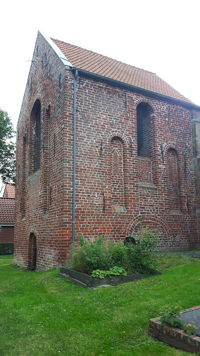
| Description | : | Westerhusen is a small hamlet, since 1972 part of the city of Hinte. The small cemetery is owned and managed by the Lutheran-Reformed Church of Westerhusen. Cemetery and baroque church date back to the 15th century, The cemetery displays a few 19th century grave markers along the church. Not the original burial spots. Please note that the graves in Germany are not perpetual. After a certain period of repose (20-30 years) the graves are being leveled and re-used. There is no toxic embalming being done in Germany, so the coffin and the corpse can decompose naturally. If the family of... Read More |
frequently asked questions (FAQ):
-
Where is Friedhof Westerhusen?
Friedhof Westerhusen is located at Landesstrasse Hinte, Landkreis Aurich ,Lower Saxony (Niedersachsen) , 26759Germany.
-
Friedhof Westerhusen cemetery's updated grave count on graveviews.com?
0 memorials
-
Where are the coordinates of the Friedhof Westerhusen?
Latitude: 53.4124958
Longitude: 7.1802259
Nearby Cemetories:
1. Alter Friedhof Hinte
Hinte, Landkreis Aurich, Germany
Coordinate: 53.4164530, 7.1949230
2. Neuer Friedhof Hinte
Hinte, Landkreis Aurich, Germany
Coordinate: 53.4121300, 7.1968390
3. Friedhof Gross Midlum
Hinte, Landkreis Aurich, Germany
Coordinate: 53.4102160, 7.1582470
4. Friedhof Cirkwehrum
Cirkwehrum, Landkreis Aurich, Germany
Coordinate: 53.4374470, 7.1717340
5. Neuer Friedhof Freepsum
Freepsum, Landkreis Aurich, Germany
Coordinate: 53.4171041, 7.1381140
6. Friedhof Suurhusen
Hinte, Landkreis Aurich, Germany
Coordinate: 53.4135550, 7.2234350
7. Friedhof Harsweg
Emden, Stadtkreis Emden, Germany
Coordinate: 53.3914260, 7.2065880
8. Alter Friedhof Freepsum
Freepsum, Landkreis Aurich, Germany
Coordinate: 53.4174306, 7.1352975
9. Alter Friedhof Loppersum
Hinte, Landkreis Aurich, Germany
Coordinate: 53.4244880, 7.2316900
10. Neuer Friedhof Loppersum
Hinte, Landkreis Aurich, Germany
Coordinate: 53.4289850, 7.2332520
11. Friedhof Auricher Strasse
Emden, Stadtkreis Emden, Germany
Coordinate: 53.3773900, 7.2067300
12. Friedhof Canum
Canum, Landkreis Aurich, Germany
Coordinate: 53.4258560, 7.1131460
13. Friedhof Uttum
Uttum, Landkreis Aurich, Germany
Coordinate: 53.4521310, 7.1548700
14. Bolardusfriedhof
Emden, Stadtkreis Emden, Germany
Coordinate: 53.3743470, 7.2120230
15. Friedhof Tholenswehr
Emden, Stadtkreis Emden, Germany
Coordinate: 53.3759150, 7.2240770
16. Jüdischer Friedhof Emden
Emden, Stadtkreis Emden, Germany
Coordinate: 53.3699980, 7.2123830
17. Friedhof Marienwehr
Emden, Stadtkreis Emden, Germany
Coordinate: 53.3955860, 7.2541690
18. Friedhof Große Kirche
Emden, Stadtkreis Emden, Germany
Coordinate: 53.3656450, 7.2013280
19. Friedhof Neue Kirche
Emden, Stadtkreis Emden, Germany
Coordinate: 53.3678380, 7.2140420
20. Friedhof Twixlum
Emden, Stadtkreis Emden, Germany
Coordinate: 53.3705980, 7.1331900
21. Friedhof Larrelt
Larrelt, Stadtkreis Emden, Germany
Coordinate: 53.3649130, 7.1495020
22. Friedhof Wolthusen
Emden, Stadtkreis Emden, Germany
Coordinate: 53.3701780, 7.2337400
23. Friedhof Woltzeten
Woltzeten, Landkreis Aurich, Germany
Coordinate: 53.4113220, 7.0907320
24. Neuer Friedhof Pewsum
Pewsum, Landkreis Aurich, Germany
Coordinate: 53.4352780, 7.0972220