| Memorials | : | 0 |
| Location | : | Woltzeten, Landkreis Aurich, Germany |
| Coordinate | : | 53.4113220, 7.0907320 |
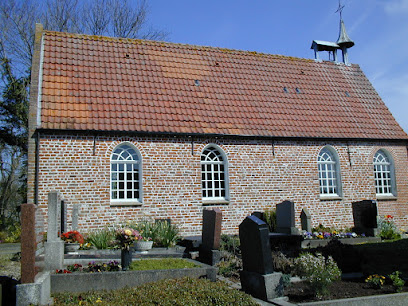
| Description | : | Contact: Evangelisch-reformierte Kirchengemeinde Woltzeten Dorfring 14 26736 Krummhörn-Woltzeten GERMANY Woltzeten is one of 19 villages that form the municipality of Krummhörn. A cemetery had been at this location since the Middle Ages. The current church (Woltzetener Kirche) was built in 1727, replacing a structure from the 12th century. A few historic grave stones are displayed inside and along the outside of the building. The cemetery and church belong to the Lutheran-Reformed Congregation of Woltzeten. Please note that the graves in Germany are not perpetual. After a certain period of repose (20-30 years) the graves are being leveled and re-used. There is no toxic embalming being done... Read More |
frequently asked questions (FAQ):
-
Where is Friedhof Woltzeten?
Friedhof Woltzeten is located at Roseneck 1-4 Woltzeten, Landkreis Aurich ,Lower Saxony (Niedersachsen) , 26736Germany.
-
Friedhof Woltzeten cemetery's updated grave count on graveviews.com?
0 memorials
-
Where are the coordinates of the Friedhof Woltzeten?
Latitude: 53.4113220
Longitude: 7.0907320
Nearby Cemetories:
1. Friedhof Canum
Canum, Landkreis Aurich, Germany
Coordinate: 53.4258560, 7.1131460
2. Marienkirche Woquard
Woquard, Landkreis Aurich, Germany
Coordinate: 53.4309170, 7.0841630
3. Neuer Friedhof Pewsum
Pewsum, Landkreis Aurich, Germany
Coordinate: 53.4352780, 7.0972220
4. Alter Friedhof Pewsum
Pewsum, Landkreis Aurich, Germany
Coordinate: 53.4354205, 7.0961914
5. Neuer Friedhof Campen
Campen, Landkreis Aurich, Germany
Coordinate: 53.4021008, 7.0497335
6. Alter Friedhof Campen
Campen, Landkreis Aurich, Germany
Coordinate: 53.3997600, 7.0511100
7. Alter Friedhof Freepsum
Freepsum, Landkreis Aurich, Germany
Coordinate: 53.4174306, 7.1352975
8. Neuer Friedhof Freepsum
Freepsum, Landkreis Aurich, Germany
Coordinate: 53.4171041, 7.1381140
9. Friedhof Groothusen
Landkreis Aurich, Germany
Coordinate: 53.4365940, 7.0644730
10. Friedhof Hamswehrum
Hamswehrum, Landkreis Aurich, Germany
Coordinate: 53.4299150, 7.0513950
11. Alter Friedhof Loquard
Loquard, Landkreis Aurich, Germany
Coordinate: 53.3901130, 7.0453450
12. Neuer Friedhof Loquard
Loquard, Landkreis Aurich, Germany
Coordinate: 53.3893800, 7.0422280
13. Friedhof Gross Midlum
Hinte, Landkreis Aurich, Germany
Coordinate: 53.4102160, 7.1582470
14. Alter Friedhof Rysum
Rysum, Landkreis Aurich, Germany
Coordinate: 53.3794840, 7.0353940
15. Neuer Friedhof Rysum
Rysum, Landkreis Aurich, Germany
Coordinate: 53.3795900, 7.0339070
16. Friedhof Twixlum
Emden, Stadtkreis Emden, Germany
Coordinate: 53.3705980, 7.1331900
17. Friedhof Manslagt
Manslagt, Landkreis Aurich, Germany
Coordinate: 53.4580570, 7.0626410
18. Friedhof Westerhusen
Hinte, Landkreis Aurich, Germany
Coordinate: 53.4124958, 7.1802259
19. Friedhof Cirkwehrum
Cirkwehrum, Landkreis Aurich, Germany
Coordinate: 53.4374470, 7.1717340
20. Friedhof Uttum
Uttum, Landkreis Aurich, Germany
Coordinate: 53.4521310, 7.1548700
21. Friedhof Visquard
Visquard, Landkreis Aurich, Germany
Coordinate: 53.4677850, 7.0985590
22. Friedhof Jennelt
Landkreis Aurich, Germany
Coordinate: 53.4632390, 7.1320560
23. Neuer Friedhof Wybelsum
Wybelsum, Stadtkreis Emden, Germany
Coordinate: 53.3544100, 7.1055590
24. Friedhof Larrelt
Larrelt, Stadtkreis Emden, Germany
Coordinate: 53.3649130, 7.1495020

