
| Memorials | : | 0 |
| Location | : | Addingham, Metropolitan Borough of Bradford, England |
| Coordinate | : | 53.9621000, 1.8855000 |
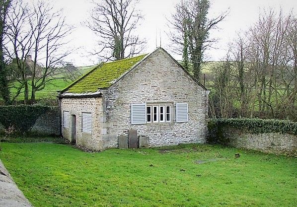
| Description | : | "Farfield Friends' Meeting House, Bolton Road (B6160), Addingham, West Yorkshire, England. It was built in the same year as the Toleration Act, 1689, but has not been used by the Society of Friends for 150 years. It is in the care of the Historic Chapels Trust". Please visit the Wikipedia page posted above for a wonderful description of this early meeting house. Thank you to : By Humphrey Bolton, CC BY-SA 2.0, https://commons.wikimedia.org/w/index.php?curid=10757215 for sharing photo of meeting house. |
frequently asked questions (FAQ):
-
Where is Friends Burial Ground at Farfield?
Friends Burial Ground at Farfield is located at Bolton Road Addingham, Metropolitan Borough of Bradford ,West Yorkshire ,England.
-
Friends Burial Ground at Farfield cemetery's updated grave count on graveviews.com?
0 memorials
-
Where are the coordinates of the Friends Burial Ground at Farfield?
Latitude: 53.9621000
Longitude: 1.8855000
Nearby Cemetories:
1. Addingham Church Orchard
Addingham, Metropolitan Borough of Bradford, England
Coordinate: 53.9456460, 1.8856610
2. St. James Chapelyard
Crowden, High Peak Borough, England
Coordinate: 53.4921410, 1.8811550
3. St Mary the Virgin
Manchester, Metropolitan Borough of Manchester, England
Coordinate: 53.4839000, 2.3334000
4. Church of St. Mary the Virgin
Beighton, Metropolitan Borough of Sheffield, England
Coordinate: 53.3446000, 1.3356000
5. St Mary's Church
Bolsover, Bolsover District, England
Coordinate: 53.2310000, 1.2897000
6. St. Peter and St. Paul Churchyard
Cromer, North Norfolk District, England
Coordinate: 52.9312500, 1.3011111
7. St Helen Churchyard
Kilnsea, East Riding of Yorkshire Unitary Authority, England
Coordinate: 53.6199600, 0.1318900
8. All Saints Churchyard
Easington, East Riding of Yorkshire Unitary Authority, England
Coordinate: 53.6504160, 0.1148520
9. Cromer Old Cemetery
Cromer, North Norfolk District, England
Coordinate: 52.9292270, 1.2897670
10. All Saints Churchyard
Beeston Regis, North Norfolk District, England
Coordinate: 52.9408700, 1.2340790
11. Easington Parish Council Cemetery
Easington, East Riding of Yorkshire Unitary Authority, England
Coordinate: 53.6455910, 0.1125800
12. St. Martin's Churchyard
Overstrand, North Norfolk District, England
Coordinate: 52.9174550, 1.3314910
13. Cromer Cemetery
Cromer, North Norfolk District, England
Coordinate: 52.9204800, 1.2730300
14. St. Nicholas' Churchyard
Holmpton, East Riding of Yorkshire Unitary Authority, England
Coordinate: 53.6888400, 0.0689200
15. St. Mary's Churchyard
Northrepps, North Norfolk District, England
Coordinate: 52.9019100, 1.3361300
16. All Saints Churchyard
Mundesley, North Norfolk District, England
Coordinate: 52.8803700, 1.4324000
17. St. John the Baptist Churchyard
Aylmerton, North Norfolk District, England
Coordinate: 52.9139032, 1.2435925
18. St Nicholas Churchyard
Salthouse, North Norfolk District, England
Coordinate: 52.9503200, 1.0889800
19. St. Nicholas' Churchyard
Hollym, East Riding of Yorkshire Unitary Authority, England
Coordinate: 53.7063300, 0.0359100
20. St. Margaret Churchyard
Felbrigg, North Norfolk District, England
Coordinate: 52.9035450, 1.2660760
21. All Saints Churchyard
Gimingham, North Norfolk District, England
Coordinate: 52.8790220, 1.3948380
22. Chipchase Castle Chapel
Hexham, Northumberland Unitary Authority, England
Coordinate: 55.0756000, 2.1860000
23. St. Mary the Virgin Churchyard
Kelling, North Norfolk District, England
Coordinate: 52.9322300, 1.1053700
24. Carmelite Friary of the Blessed Virgin
Blakeney, North Norfolk District, England
Coordinate: 52.9553240, 1.0234250