
| Memorials | : | 1 |
| Location | : | St Helens, Metropolitan Borough of St Helens, England |
| Coordinate | : | 53.4518340, -2.7320414 |
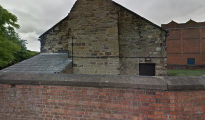
| Description | : | The meeting house is the oldest building in St Helens town centre, but there are uncertainties over the exact date of the building. Butler suggests a date of c1600, the Historic England List entry states it dates from 1679 – 92 and Presland dates the building earlier than 1597. The Historic Environment Record notes that the building and burial ground were conveyed in 1679. What is clear, however, is the beginnings of the meeting house and burial ground. A horse collar maker from Bickerstaffe named George Shaw purchased three plots of land in the area in 1676; he gave the... Read More |
frequently asked questions (FAQ):
-
Where is Friends Meeting House, Hardshaw, St Helens?
Friends Meeting House, Hardshaw, St Helens is located at Church Street, St Helens St Helens, Metropolitan Borough of St Helens ,Merseyside , WA10 1AJEngland.
-
Friends Meeting House, Hardshaw, St Helens cemetery's updated grave count on graveviews.com?
1 memorials
-
Where are the coordinates of the Friends Meeting House, Hardshaw, St Helens?
Latitude: 53.4518340
Longitude: -2.7320414
Nearby Cemetories:
1. St Peter's of Parr Churchyard
Parr, Metropolitan Borough of St Helens, England
Coordinate: 53.4543745, -2.7009772
2. Windleshaw Chantry
St Helens, Metropolitan Borough of St Helens, England
Coordinate: 53.4672417, -2.7550773
3. St. Helen's Cemetery and Crematorium
St Helens, Metropolitan Borough of St Helens, England
Coordinate: 53.4678993, -2.7607000
4. St. Anne and Blessed Dominic Churchyard
St Helens, Metropolitan Borough of St Helens, England
Coordinate: 53.4330960, -2.7083700
5. St Nicholas Churchyard
St Helens, Metropolitan Borough of St Helens, England
Coordinate: 53.4284660, -2.7213830
6. Christ Church Churchyard
Eccleston, Metropolitan Borough of St Helens, England
Coordinate: 53.4542560, -2.7778900
7. St Mark Churchyard
Haydock, Metropolitan Borough of St Helens, England
Coordinate: 53.4658540, -2.6892980
8. St Mary Roman Catholic Churchyard
Billinge, Metropolitan Borough of St Helens, England
Coordinate: 53.4909850, -2.7180090
9. St Ann’s Graveyard
Rainhill, Metropolitan Borough of St Helens, England
Coordinate: 53.4157487, -2.7638276
10. St Bartholomew's Churchyard
Rainhill, Metropolitan Borough of St Helens, England
Coordinate: 53.4076231, -2.7513287
11. St James' Churchyard
Haydock, Metropolitan Borough of St Helens, England
Coordinate: 53.4679080, -2.6596350
12. GreenAcres Cemetery
Rainford, Metropolitan Borough of St Helens, England
Coordinate: 53.4713530, -2.8064280
13. St. Mary the Virgin Churchyard
Prescot, Metropolitan Borough of Knowsley, England
Coordinate: 53.4284600, -2.8067000
14. Prescot Cemetery
Prescot, Metropolitan Borough of Knowsley, England
Coordinate: 53.4266620, -2.8081590
15. Knowsley Cemetery
Knowsley, Metropolitan Borough of Knowsley, England
Coordinate: 53.4083240, -2.7847870
16. All Saints Church
Rainford, Metropolitan Borough of St Helens, England
Coordinate: 53.5000210, -2.7870990
17. St. Mary and St. John RC Churchyard
Newton-le-Willows, Metropolitan Borough of St Helens, England
Coordinate: 53.4559410, -2.6323930
18. Holy Trinity Churchyard
Ashton-In-Makerfield, Metropolitan Borough of Wigan, England
Coordinate: 53.4989280, -2.6688000
19. St. Nicholas' Churchyard
Whiston, Metropolitan Borough of Knowsley, England
Coordinate: 53.4069736, -2.8028920
20. Emmanuel Wargrave
Newton-le-Willows, Metropolitan Borough of St Helens, England
Coordinate: 53.4454500, -2.6277060
21. St Thomas Churchyard
Ashton-In-Makerfield, Metropolitan Borough of Wigan, England
Coordinate: 53.4856362, -2.6402671
22. Newton-le-Willows Cemetery
Newton-le-Willows, Metropolitan Borough of St Helens, England
Coordinate: 53.4471970, -2.6217090
23. St Thomas' Churchyard (Heath Road Extension)
Ashton-In-Makerfield, Metropolitan Borough of Wigan, England
Coordinate: 53.4850470, -2.6345810
24. St. Luke's Churchyard
Farnworth, Halton Unitary Authority, England
Coordinate: 53.3843810, -2.7271840