
| Memorials | : | 1 |
| Location | : | Golden Grove, Tea Tree Gully City, Australia |
| Phone | : | +61 8 8251 4298 |
| Website | : | www.goldengroveuniting.org.au/ |
| Coordinate | : | -34.7883129, 138.7091051 |
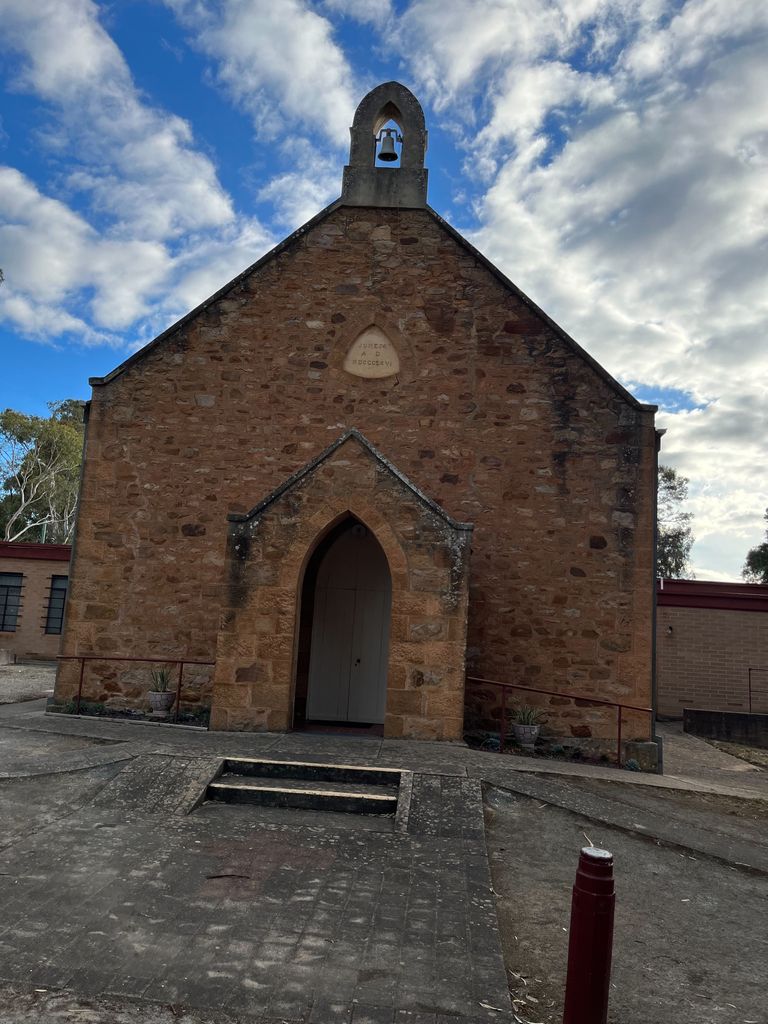
| Description | : | Although many consider Golden Grove as a well-planned new housing development, it was actually settled in 1838, two years after the establishment of the colony of South Australia. The early settlers were mostly farmers, or tended orchards and vineyards, but they were just as concerned to provide for their families, build a home, and to ensure a Christian education for their children, as many parents of today. We acknowledge the Christian commitment, strength, vision and tenacity of the early settlers in this area. In 1864 Capt. John Robertson, on behalf of his late father Captain Adam Robertson (who passed away in the same... Read More |
frequently asked questions (FAQ):
-
Where is Golden Grove Uniting Church?
Golden Grove Uniting Church is located at 75 One Tree Hill Road, Golden Grove SA Golden Grove, Tea Tree Gully City ,South Australia , 5125Australia.
-
Golden Grove Uniting Church cemetery's updated grave count on graveviews.com?
1 memorials
-
Where are the coordinates of the Golden Grove Uniting Church?
Latitude: -34.7883129
Longitude: 138.7091051
Nearby Cemetories:
1. Greenwith Uniting Church
Golden Grove, Tea Tree Gully City, Australia
Coordinate: -34.7849500, 138.7187400
2. Golden Grove Cemetery
Golden Grove, Tea Tree Gully City, Australia
Coordinate: -34.7748502, 138.7318420
3. Drumminor Gardens
Ridgehaven, Tea Tree Gully City, Australia
Coordinate: -34.8195240, 138.6968120
4. Little Para Wesleyan Cemetery
Hillbank, Playford City, Australia
Coordinate: -34.7479620, 138.6836570
5. Salisbury Pioneer Catholic Cemetery
Salisbury, Salisbury City, Australia
Coordinate: -34.7627130, 138.6520780
6. St. John's Churchyard
Salisbury, Salisbury City, Australia
Coordinate: -34.7644090, 138.6463600
7. Hope Valley Cemetery
Hope Valley, Tea Tree Gully City, Australia
Coordinate: -34.8441550, 138.6954700
8. Salisbury Methodist Church Cemetery
Salisbury, Salisbury City, Australia
Coordinate: -34.7616800, 138.6452510
9. Salisbury Memorial Park
Salisbury, Salisbury City, Australia
Coordinate: -34.7737160, 138.6382070
10. Houghton Cemetery
Houghton, Adelaide Hills Council, Australia
Coordinate: -34.8280580, 138.7680070
11. Athelstone Gorge Primitive Methodist Cemetery
Athelstone, Campbelltown City, Australia
Coordinate: -34.8646690, 138.7133650
12. Holy Cross Anglican Church
Elizabeth, Salisbury City, Australia
Coordinate: -34.7147160, 138.6724910
13. One Tree Hill Uniting Church Cemetery
One Tree Hill, Playford City, Australia
Coordinate: -34.7185200, 138.7682710
14. Sturton Family Cemetery
Penfield, Playford City, Australia
Coordinate: -34.7255460, 138.6375980
15. Athelstone Independent Cemetery
Athelstone, Campbelltown City, Australia
Coordinate: -34.8744850, 138.6956870
16. St. Martin's Anglican Church Cemetery
Campbelltown, Campbelltown City, Australia
Coordinate: -34.8762440, 138.6662340
17. Burton Pioneer Cemetery
Paralowie, Salisbury City, Australia
Coordinate: -34.7532480, 138.6013050
18. Uley Baptist Church Cemetery
Uleybury, Playford City, Australia
Coordinate: -34.6954070, 138.7575960
19. Enfield Memorial Park
Clearview, Port Adelaide Enfield City, Australia
Coordinate: -34.8580920, 138.6121010
20. Chain of Ponds Cemetery
Chain of Ponds, Adelaide Hills Council, Australia
Coordinate: -34.8230300, 138.8316500
21. Montacute Cemetery
Montacute, Adelaide Hills Council, Australia
Coordinate: -34.8911600, 138.7505000
22. Klemzig Pioneer Memorial Garden
Klemzig, Port Adelaide Enfield City, Australia
Coordinate: -34.8832580, 138.6432830
23. Kersbrook Wesleyan Methodist Cemetery
Kersbrook, Adelaide Hills Council, Australia
Coordinate: -34.7900482, 138.8482557
24. Kersbrook Cemetery
Kersbrook, Adelaide Hills Council, Australia
Coordinate: -34.8040693, 138.8486109