
| Memorials | : | 0 |
| Location | : | Madison County, USA |
| Coordinate | : | 34.9213770, -86.7727470 |
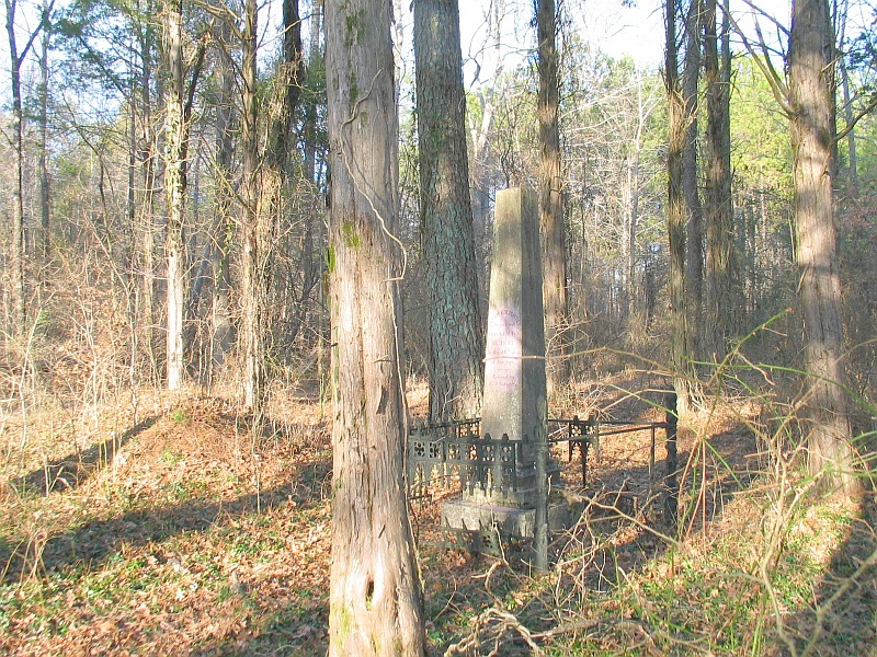
| Description | : | Turn off of Ardmore Highway west and go 3 tenths of a mile on Shady Grove Road to a new house on the left in front of the cemetery. After permission go behind the house and follow a field road 400+ yards until it opens out into a small field. Stop while still standing in the field road and look 90 degrees left (or north) under the trees and the tall monument can be seen under the cedar and pine trees. In other words the big monument is is seen inside an iron fence as you come out into the... Read More |
frequently asked questions (FAQ):
-
Where is Golightly Cemetery?
Golightly Cemetery is located at Madison County ,Alabama ,USA.
-
Golightly Cemetery cemetery's updated grave count on graveviews.com?
0 memorials
-
Where are the coordinates of the Golightly Cemetery?
Latitude: 34.9213770
Longitude: -86.7727470
Nearby Cemetories:
1. Adams-Crutcher Cemetery
Madison County, USA
Coordinate: 34.9071999, -86.7835999
2. Hatchett Cemetery
Limestone County, USA
Coordinate: 34.9196500, -86.7994600
3. Hardin Cemetery
Limestone County, USA
Coordinate: 34.9166985, -86.8056030
4. Mitchell Cemetery #1
Athens, Limestone County, USA
Coordinate: 34.8882320, -86.7860500
5. Jones Cemetery
Limestone County, USA
Coordinate: 34.9291992, -86.8155975
6. Johnson Cemetery
Limestone County, USA
Coordinate: 34.9432983, -86.8106003
7. Pulley Cemetery
Harvest, Madison County, USA
Coordinate: 34.8781013, -86.7636032
8. Booker Cemetery
Harvest, Madison County, USA
Coordinate: 34.8782997, -86.7489014
9. Center Hill Cemetery
Harvest, Madison County, USA
Coordinate: 34.8739014, -86.7835999
10. Carroll Cemetery
Harvest, Madison County, USA
Coordinate: 34.8709330, -86.7664330
11. Kincaid Cemetery
Madison County, USA
Coordinate: 34.9068985, -86.7108002
12. J F Smith Cemetery
Madison County, USA
Coordinate: 34.8777600, -86.7234500
13. Kincaid Cemetery
Madison County, USA
Coordinate: 34.8835983, -86.7146988
14. Powers Cemetery
Harvest, Madison County, USA
Coordinate: 34.8608017, -86.7583008
15. Delap Cemetery
Limestone County, USA
Coordinate: 34.9752998, -86.8103027
16. Browning Cemetery
Harvest, Madison County, USA
Coordinate: 34.8567009, -86.7553024
17. Carter Cemetery
Limestone County, USA
Coordinate: 34.8558006, -86.7947006
18. Bouldin-Hammond Cemetery
Harvest, Madison County, USA
Coordinate: 34.8553009, -86.7328033
19. Hall Cemetery
Limestone County, USA
Coordinate: 34.8621650, -86.8280670
20. Gatlin Cemetery
Ardmore, Limestone County, USA
Coordinate: 34.9897003, -86.8099976
21. Hutchings Cemetery
Harvest, Madison County, USA
Coordinate: 34.8443985, -86.7686005
22. Tuck Cemetery
Harvest, Madison County, USA
Coordinate: 34.8446999, -86.7500000
23. Hopwood Cemetery
Ardmore, Limestone County, USA
Coordinate: 34.9916992, -86.8171997
24. The Good Earth Burial Ground
Hazel Green, Madison County, USA
Coordinate: 34.9670790, -86.6926110