
| Memorials | : | 12 |
| Location | : | Eurekaton, Haywood County, USA |
| Coordinate | : | 35.4441000, -89.2296400 |
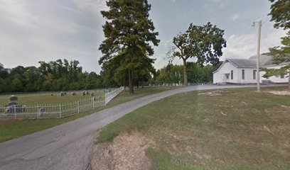
| Description | : | African American Cemetery. Located on the north side of Highway 179, in the southeastern section of Haywood County. Situated at the end of Good Hope Cemetery (dirt & gravel) Road, about 0.1 mile north of this highway and up behind the Harmony Baptist Church and the white burial ground. Note: Also called Good Hope – Harmony. The blacks and whites worshiped here together until 1868, with both using adjoining cemeteries. The black church located elsewhere and was called the Good Hope Missionary Baptist Church. |
frequently asked questions (FAQ):
-
Where is Good Hope Baptist Church Cemetery?
Good Hope Baptist Church Cemetery is located at 3890 Eurekaton Rd Eurekaton, Haywood County ,Tennessee ,USA.
-
Good Hope Baptist Church Cemetery cemetery's updated grave count on graveviews.com?
12 memorials
-
Where are the coordinates of the Good Hope Baptist Church Cemetery?
Latitude: 35.4441000
Longitude: -89.2296400
Nearby Cemetories:
1. Harmony Baptist Church Cemetery
Eurekaton, Haywood County, USA
Coordinate: 35.4434850, -89.2294390
2. Good Hope M.B. Church Cemetery
Dancyville, Haywood County, USA
Coordinate: 35.4491000, -89.2134600
3. Saint James Cemetery
Stanton, Haywood County, USA
Coordinate: 35.4409000, -89.2526000
4. Spring Hill United Methodist Cemetery
Ko Ko, Haywood County, USA
Coordinate: 35.4508820, -89.2725990
5. Miller Family Cemetery
Dancyville, Haywood County, USA
Coordinate: 35.4078860, -89.2306050
6. Prospect CME Church Cemetery #2
Willis, Haywood County, USA
Coordinate: 35.4537290, -89.2756300
7. Moore Cemetery
Hillville, Haywood County, USA
Coordinate: 35.4586590, -89.1810550
8. Saint John Missionary Baptist Cemetery
Dancyville, Haywood County, USA
Coordinate: 35.4397011, -89.2866974
9. Mount Pleasant Cemetery
Hillville, Haywood County, USA
Coordinate: 35.4516390, -89.1693320
10. Old Jones Cemetery
Fayette Corners, Fayette County, USA
Coordinate: 35.3973310, -89.2552120
11. Morton Hill Cemetery
Stanton, Haywood County, USA
Coordinate: 35.4713420, -89.2881640
12. Sammons Cemetery
Cedar Chapel, Hardeman County, USA
Coordinate: 35.4053460, -89.1782850
13. Dancyville Presbyterian Cemetery
Dancyville, Haywood County, USA
Coordinate: 35.4088720, -89.2926660
14. Russell Grove Missionary Baptist Church Cemetery
Fayette Corners, Fayette County, USA
Coordinate: 35.3813160, -89.2408340
15. Dancyville United Methodist Church Cemetery
Dancyville, Haywood County, USA
Coordinate: 35.4050000, -89.2942000
16. Smith Cemetery
Cedar Chapel, Hardeman County, USA
Coordinate: 35.4041230, -89.1654670
17. Dancyville C.M.E. Cemetery
Dancyville, Haywood County, USA
Coordinate: 35.4102410, -89.2996060
18. Old Saint John MB Church Cemetery
Dancyville, Haywood County, USA
Coordinate: 35.4056000, -89.2984000
19. Dancyville Assembly of God Church Cemetery
Dancyville, Haywood County, USA
Coordinate: 35.4005380, -89.2990170
20. Smyrna Cemetery
Fayette Corners, Fayette County, USA
Coordinate: 35.3691500, -89.2264000
21. Scratchunder Cemetery
Stanton, Haywood County, USA
Coordinate: 35.4989250, -89.2935370
22. Mount Tabor Baptist Church Cemetery
Whiteville, Hardeman County, USA
Coordinate: 35.3981970, -89.1541430
23. Hillville Family Cemetery
Haywood County, USA
Coordinate: 35.4488160, -89.1342780
24. Clover Garden CME Church Cemetery
Whiteville, Hardeman County, USA
Coordinate: 35.3677600, -89.2070700