
| Memorials | : | 0 |
| Location | : | Eurekaton, Haywood County, USA |
| Coordinate | : | 35.4434850, -89.2294390 |
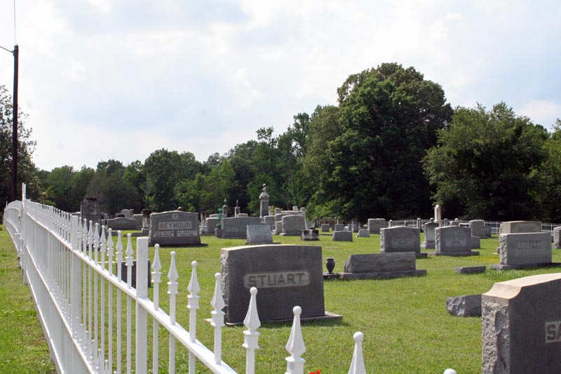
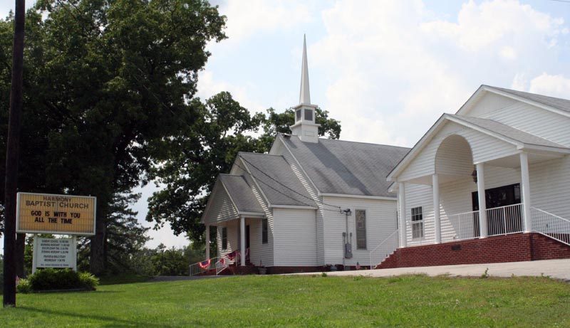
| Description | : | Highway 76 south from Brownsville, at Koko turn left on Highway 179 (Eurekaton Road). Cemetery is about 4 miles on the left Harmony Baptist Church was organized 14 October 1837 east of the Haywood - Hardeman County line and about a mile and half west of Cedar Chapel. In 1840, the church moved to the present location on the Brownsville and Whiteville Road on land donated by Tom Short, who designated the cemetery was to be a free burying ground. 1938, Cemetery Association Organized. 1980, Perpetual Care Trust set up. Up until the end of the Civil... Read More |
frequently asked questions (FAQ):
-
Where is Harmony Baptist Church Cemetery?
Harmony Baptist Church Cemetery is located at Eurekaton, Haywood County ,Tennessee ,USA.
-
Harmony Baptist Church Cemetery cemetery's updated grave count on graveviews.com?
0 memorials
-
Where are the coordinates of the Harmony Baptist Church Cemetery?
Latitude: 35.4434850
Longitude: -89.2294390
Nearby Cemetories:
1. Good Hope Baptist Church Cemetery
Eurekaton, Haywood County, USA
Coordinate: 35.4441000, -89.2296400
2. Good Hope M.B. Church Cemetery
Dancyville, Haywood County, USA
Coordinate: 35.4491000, -89.2134600
3. Saint James Cemetery
Stanton, Haywood County, USA
Coordinate: 35.4409000, -89.2526000
4. Miller Family Cemetery
Dancyville, Haywood County, USA
Coordinate: 35.4078860, -89.2306050
5. Spring Hill United Methodist Cemetery
Ko Ko, Haywood County, USA
Coordinate: 35.4508820, -89.2725990
6. Prospect CME Church Cemetery #2
Willis, Haywood County, USA
Coordinate: 35.4537290, -89.2756300
7. Moore Cemetery
Hillville, Haywood County, USA
Coordinate: 35.4586590, -89.1810550
8. Saint John Missionary Baptist Cemetery
Dancyville, Haywood County, USA
Coordinate: 35.4397011, -89.2866974
9. Mount Pleasant Cemetery
Hillville, Haywood County, USA
Coordinate: 35.4516390, -89.1693320
10. Old Jones Cemetery
Fayette Corners, Fayette County, USA
Coordinate: 35.3973310, -89.2552120
11. Morton Hill Cemetery
Stanton, Haywood County, USA
Coordinate: 35.4713420, -89.2881640
12. Sammons Cemetery
Cedar Chapel, Hardeman County, USA
Coordinate: 35.4053460, -89.1782850
13. Dancyville Presbyterian Cemetery
Dancyville, Haywood County, USA
Coordinate: 35.4088720, -89.2926660
14. Russell Grove Missionary Baptist Church Cemetery
Fayette Corners, Fayette County, USA
Coordinate: 35.3813160, -89.2408340
15. Dancyville United Methodist Church Cemetery
Dancyville, Haywood County, USA
Coordinate: 35.4050000, -89.2942000
16. Smith Cemetery
Cedar Chapel, Hardeman County, USA
Coordinate: 35.4041230, -89.1654670
17. Dancyville C.M.E. Cemetery
Dancyville, Haywood County, USA
Coordinate: 35.4102410, -89.2996060
18. Old Saint John MB Church Cemetery
Dancyville, Haywood County, USA
Coordinate: 35.4056000, -89.2984000
19. Dancyville Assembly of God Church Cemetery
Dancyville, Haywood County, USA
Coordinate: 35.4005380, -89.2990170
20. Smyrna Cemetery
Fayette Corners, Fayette County, USA
Coordinate: 35.3691500, -89.2264000
21. Scratchunder Cemetery
Stanton, Haywood County, USA
Coordinate: 35.4989250, -89.2935370
22. Mount Tabor Baptist Church Cemetery
Whiteville, Hardeman County, USA
Coordinate: 35.3981970, -89.1541430
23. Hillville Family Cemetery
Haywood County, USA
Coordinate: 35.4488160, -89.1342780
24. Clover Garden CME Church Cemetery
Whiteville, Hardeman County, USA
Coordinate: 35.3677600, -89.2070700