| Memorials | : | 0 |
| Location | : | Clayton, Johnston County, USA |
| Coordinate | : | 35.6394501, -78.5274963 |
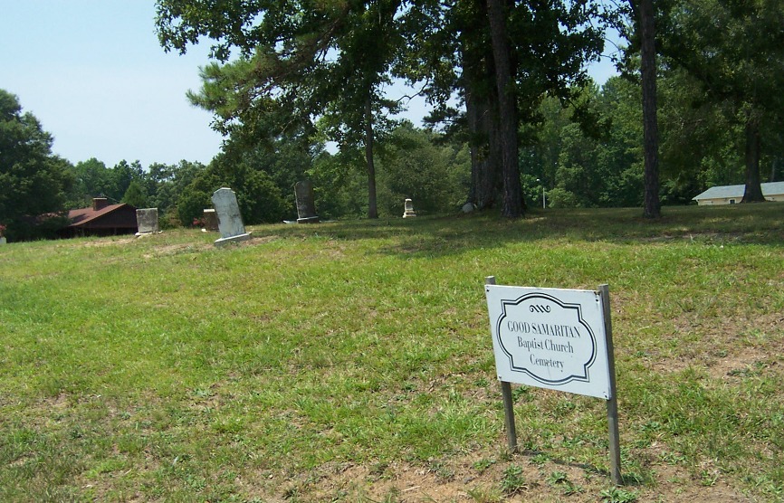
| Description | : | Lat. 35° 38' 21.77" N Long. 78° 31' 38.71" W The Good Samaritan Baptist Church Cemetery is located near the intersection of Winston Road and Cornwallis Road/White Oak Road in Clayton, NC. This is in Johnston County. It is located on the church grounds beside the road. A driveway from Winston Road provides access. The graves are spaced out in the field along the road and has a sign that reads "Good Samaritan Baptist Church Cemetery". The grounds were well kept and clean. There is one grave covered by a ground level concrete vault with no markings. There may be unmarked graves. |
frequently asked questions (FAQ):
-
Where is Good Samaritan Baptist Church Cemetery?
Good Samaritan Baptist Church Cemetery is located at Clayton, Johnston County ,North Carolina ,USA.
-
Good Samaritan Baptist Church Cemetery cemetery's updated grave count on graveviews.com?
0 memorials
-
Where are the coordinates of the Good Samaritan Baptist Church Cemetery?
Latitude: 35.6394501
Longitude: -78.5274963
Nearby Cemetories:
1. Wiley D. Jones Cemetery
Clayton, Johnston County, USA
Coordinate: 35.6476800, -78.5027010
2. Amelia Christian Church Cemetery
Clayton, Johnston County, USA
Coordinate: 35.6365810, -78.4957920
3. Mount Herman Christian Church Cemetery
Garner, Wake County, USA
Coordinate: 35.6621399, -78.5468369
4. Good Samaritan Baptist Church Cemetery
Garner, Wake County, USA
Coordinate: 35.6576510, -78.5595890
5. Pinecrest Memorial Gardens
Clayton, Johnston County, USA
Coordinate: 35.6644096, -78.4939880
6. Mount Moriah Baptist Church Cemetery
Raleigh, Wake County, USA
Coordinate: 35.6847310, -78.5270990
7. Burrell Boon Cemetery
Clayton, Johnston County, USA
Coordinate: 35.6164060, -78.4761950
8. Gower Cemetery (Defunct)
Johnston County, USA
Coordinate: 35.6024870, -78.5707320
9. Poole Cemetery
Clayton, Johnston County, USA
Coordinate: 35.6091995, -78.4760971
10. McCullers Cemetery
Clayton, Johnston County, USA
Coordinate: 35.6617012, -78.4677963
11. Maplewood Cemetery
Clayton, Johnston County, USA
Coordinate: 35.6441116, -78.4592972
12. Clayton City Cemetery
Clayton, Johnston County, USA
Coordinate: 35.6577170, -78.4624260
13. Sanders and Williamson Family Cemetery
Clayton, Johnston County, USA
Coordinate: 35.6148580, -78.4650750
14. Shiloh Baptist Church Cemetery
Clayton, Johnston County, USA
Coordinate: 35.5864792, -78.5531921
15. Horne Cemetery
Clayton, Johnston County, USA
Coordinate: 35.6581001, -78.4599991
16. Springfield Baptist Church Community Cemetery
Garner, Wake County, USA
Coordinate: 35.6978730, -78.5427090
17. Baptist Center Church Cemetery
Clayton, Johnston County, USA
Coordinate: 35.5973550, -78.4745640
18. Piney Grove Cemetery
Clayton, Johnston County, USA
Coordinate: 35.5884760, -78.4860830
19. Auburn Christian Church Cemetery
Garner, Wake County, USA
Coordinate: 35.6963400, -78.5574810
20. Stevens Family Cemetery
Garner, Wake County, USA
Coordinate: 35.6152778, -78.6002778
21. Turner Cemetery
Cary, Wake County, USA
Coordinate: 35.6292000, -78.6066971
22. Bell-McCullers Cemetery
Clayton, Johnston County, USA
Coordinate: 35.6811000, -78.4639690
23. Penny Cemetery
Wake County, USA
Coordinate: 35.6074982, -78.5997009
24. Forest Hills Cemetery
Clayton, Johnston County, USA
Coordinate: 35.6218240, -78.4453820

