
| Memorials | : | 3 |
| Location | : | Marion, Marion County, USA |
| Coordinate | : | 34.2496986, -79.3929977 |
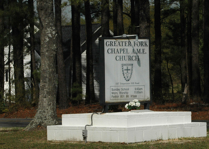
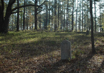
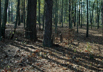
| Description | : | Located: In wooded area behind Greater Fork Chapel AME Church. Directions: Travel North on Hwy. 501 from Marion approx. 3.1 miles past 501 Business & Bypass merge point, take 1st right onto Temperance Hill Rd. traveling approx. 1.1 miles to Great Fork Chapel AME Church on left, turn left onto Kirton Place (dirt road) just past the church traveling approx. 0.2 miles to cemetery on left. Also known as "Greater Fork Chapel AME Church Cemetery". |
frequently asked questions (FAQ):
-
Where is Greater Fork Chapel AME Church Cemetery?
Greater Fork Chapel AME Church Cemetery is located at Marion, Marion County ,South Carolina ,USA.
-
Greater Fork Chapel AME Church Cemetery cemetery's updated grave count on graveviews.com?
3 memorials
-
Where are the coordinates of the Greater Fork Chapel AME Church Cemetery?
Latitude: 34.2496986
Longitude: -79.3929977
Nearby Cemetories:
1. Moody-Berry Cemetery
Marion County, USA
Coordinate: 34.2564011, -79.3908005
2. Spring Branch Cemetery
Spring Branch, Marion County, USA
Coordinate: 34.2425003, -79.3925018
3. Spring Branch Baptist Church Cemetery
Spring Branch, Marion County, USA
Coordinate: 34.2420998, -79.3957977
4. Sunset Gardens Cemetery
Spring Branch, Marion County, USA
Coordinate: 34.2500300, -79.4057900
5. Saint Phillips United Methodist Church Cemetery
Spring Branch, Marion County, USA
Coordinate: 34.2491700, -79.4062600
6. Wall Mausoleum
Marion, Marion County, USA
Coordinate: 34.2344800, -79.3823000
7. Platt - Deer Cemetery
Marion, Marion County, USA
Coordinate: 34.2675876, -79.3959196
8. Moody Cemetery
Marion, Marion County, USA
Coordinate: 34.2548409, -79.4154968
9. End of the Road Cemetery
Marion, Marion County, USA
Coordinate: 34.2240620, -79.3912079
10. Bethlehem Freewill Baptist Church Cemetery
Marion, Marion County, USA
Coordinate: 34.2806200, -79.3820900
11. Lane Cemetery
Temperance Hill, Marion County, USA
Coordinate: 34.2860985, -79.3891983
12. Ebenezer Methodist Church Cemetery
Temperance Hill, Marion County, USA
Coordinate: 34.2858009, -79.4105988
13. Stewart Family Cemetery
Marion County, USA
Coordinate: 34.2888985, -79.3861008
14. Gasque Cemetery
Marion County, USA
Coordinate: 34.2098000, -79.3971300
15. Union Baptist Church Cemetery
Temperance Hill, Marion County, USA
Coordinate: 34.2871475, -79.3754730
16. Turner Cemetery
Marion County, USA
Coordinate: 34.2860985, -79.4163971
17. Bryant Cemetery
Marion County, USA
Coordinate: 34.2903800, -79.3764400
18. Perritt Cemetery
Zion, Marion County, USA
Coordinate: 34.2533600, -79.3386700
19. Lee Cemetery
Marion County, USA
Coordinate: 34.2971992, -79.3918991
20. Christmas Cemetery
Sellers, Marion County, USA
Coordinate: 34.2841988, -79.4381027
21. Lane Cemetery
Marion County, USA
Coordinate: 34.2999992, -79.4049988
22. Tyndall Cemetery
Dillon County, USA
Coordinate: 34.2942009, -79.3602982
23. Johnson Cemetery
Dillon County, USA
Coordinate: 34.3003006, -79.3747025
24. Little Zion Methodist Church Cemetery
Zion, Marion County, USA
Coordinate: 34.2762000, -79.3347000