
| Memorials | : | 0 |
| Location | : | Dixonville, Douglas County, USA |
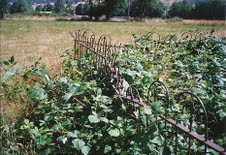
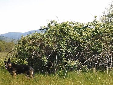
| Description | : | This cemetery was established on the William A. Willis Donation Land Claim in 1858 when his son William J. died. The Willis family arrived in Douglas Co., Oregon in 1852, traveling from Missouri on the Oregon Trail & Applegate Trail with his wife Virginia Caroline Gilmore Willis' parents and extended family. In later years, the property was purchased by Frank & Clara Hahn and the cemetery became known as the "Hahn Cemetery". Later, their son James Stephen passed away and was buried in the family cemetery as were William A. & Virginia Willis when they passed away. Through the years, the cemetery was... Read More |
frequently asked questions (FAQ):
-
Where is Hahn Cemetery?
Hahn Cemetery is located at No GPS information available Add GPSBuckhorn Road Dixonville, Douglas County ,Oregon ,USA.
-
Hahn Cemetery cemetery's updated grave count on graveviews.com?
0 memorials
Nearby Cemetories:
1. Cole Family Cemetery
Douglas County, USA
Coordinate: 43.0186005, -123.2949982
2. Coles Valley Cemetery
Coles Valley, Douglas County, USA
Coordinate: 43.0401000, -123.0826400
3. James F Gazley Family Cemetery
Gazley, Douglas County, USA
Coordinate: 43.6273390, -123.3060960
4. Indian Burial Ground
Douglas County, USA
Coordinate: 43.5943985, -123.2889023
5. Lavadoure Cemetery
Douglas County, USA
Coordinate: 43.5929160, -123.2587980
6. Leona Cemetery
Douglas County, USA
Coordinate: 43.5949120, -123.2877620
7. Letitia Cemetery
Douglas County, USA
8. Lower Smith River Cemetery
Douglas County, USA
9. McGuire Cemetery
Douglas County, USA
Coordinate: 43.6486015, -123.6500015
10. Helgeson Family Cemetery
Myrtle Creek, Douglas County, USA
Coordinate: 43.0381012, -123.1738968
11. Langenberg Burial Site
Myrtle Creek, Douglas County, USA
Coordinate: 43.0694008, -123.3591995
12. Myrtle Creek IOOF Cemetery
Myrtle Creek, Douglas County, USA
Coordinate: 43.0119019, -123.7322006
13. Pioneer Cemetery
Myrtle Creek, Douglas County, USA
Coordinate: 43.0186005, -123.2949982
14. Stephens Cemetery
Myrtle Creek, Douglas County, USA
Coordinate: 43.0401000, -123.0826400
15. Applegate Family Cemetery
Yoncalla, Douglas County, USA
Coordinate: 43.6273390, -123.3060960
16. Applegate Pioneer Cemetery
Yoncalla, Douglas County, USA
Coordinate: 43.5943985, -123.2889023
17. Cowan Family Cemetery
Yoncalla, Douglas County, USA
Coordinate: 43.5929160, -123.2587980
18. Drain-Yoncalla Masonic Cemetery
Yoncalla, Douglas County, USA
Coordinate: 43.5949120, -123.2877620
19. Long Family Cemetery
Yoncalla, Douglas County, USA
20. Robert Jackson Hendricks Farm Cemetery
Yoncalla, Douglas County, USA
21. Brown Cemetery
Douglas County, USA
Coordinate: 43.6486015, -123.6500015
22. Bryant Cemetery
Douglas County, USA
Coordinate: 43.0381012, -123.1738968
23. Burnett Cemetery
Douglas County, USA
Coordinate: 43.0694008, -123.3591995
24. Day Cemetery
Camas Valley, Douglas County, USA
Coordinate: 43.0119019, -123.7322006