
| Memorials | : | 0 |
| Location | : | Halesworth, Waveney District, England |
| Website | : | www.britishlistedbuildings.co.uk/101267197-congreagational-church-halesworth/maps |
| Coordinate | : | 52.3456000, 1.5033000 |
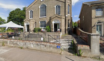
| Description | : | Formerly Congregational church Halesworth, some headstones may no longer exist. |
frequently asked questions (FAQ):
-
Where is Halesworth & Bramfield United Reformed Churchy?
Halesworth & Bramfield United Reformed Churchy is located at 16 Quay Street Halesworth Halesworth, Waveney District ,Suffolk , IP198EPUKEngland.
-
Halesworth & Bramfield United Reformed Churchy cemetery's updated grave count on graveviews.com?
0 memorials
-
Where are the coordinates of the Halesworth & Bramfield United Reformed Churchy?
Latitude: 52.3456000
Longitude: 1.5033000
Nearby Cemetories:
1. St Mary Churchyard
Halesworth, Waveney District, England
Coordinate: 52.3423990, 1.5013380
2. Halesworth Cemetery
Halesworth, Waveney District, England
Coordinate: 52.3437080, 1.5097340
3. Saint Peter's Churchyard
Holton, Waveney District, England
Coordinate: 52.3462540, 1.5259730
4. St. Peter's Churchyard
Spexhall, Waveney District, England
Coordinate: 52.3678960, 1.4923050
5. St Andrews Churchyard
Wissett, Waveney District, England
Coordinate: 52.3606730, 1.4735980
6. St. Mary Churchyard
Chediston, Suffolk Coastal District, England
Coordinate: 52.3475100, 1.4613130
7. All Saints Churchyard
Blyford, Waveney District, England
Coordinate: 52.3351840, 1.5574440
8. United Reform Churchyard
Bramfield, Suffolk Coastal District, England
Coordinate: 52.3119170, 1.5183490
9. St. Andrew's Churchyard
Bramfield, Suffolk Coastal District, England
Coordinate: 52.3102311, 1.5179990
10. St Michael and All Angels Churchyard
Cookley, Suffolk Coastal District, England
Coordinate: 52.3258980, 1.4466090
11. St. Andrew's Churchyard
Westhall, Waveney District, England
Coordinate: 52.3683891, 1.5580100
12. St. Margaret's Churchyard of Antioch
Linstead Parva, Suffolk Coastal District, England
Coordinate: 52.3477630, 1.4302960
13. Saint Peter's Churchyard
Thorington, Suffolk Coastal District, England
Coordinate: 52.3118310, 1.5534681
14. St Andrew's Churchyard
Sotherton, Waveney District, England
Coordinate: 52.3591930, 1.5837900
15. St. Michael and St. Felix's Churchyard
Rumburgh, Waveney District, England
Coordinate: 52.3845310, 1.4459590
16. St. Peter's Churchyard
Brampton, Waveney District, England
Coordinate: 52.3776520, 1.5762500
17. St. Mary The Virgin Churchyard
Huntingfield, Suffolk Coastal District, England
Coordinate: 52.3170350, 1.4263510
18. Holy Trinity Churchyard
Blythburgh, Suffolk Coastal District, England
Coordinate: 52.3211920, 1.5947390
19. St. Peters Churchyard
Redisham, Waveney District, England
Coordinate: 52.4041120, 1.5389330
20. St. Margaret's Churchyard
Stoven, Waveney District, England
Coordinate: 52.3777910, 1.5951750
21. St. James' Churchyard
South Elmham St James, Waveney District, England
Coordinate: 52.3796890, 1.4113370
22. St Mary Churchyard
Uggeshall, Waveney District, England
Coordinate: 52.3665630, 1.6054470
23. St Margaret Churchyard
Heveningham, Suffolk Coastal District, England
Coordinate: 52.3017670, 1.4209263
24. All Saints Churchyard
South Elmham St Nicholas, Waveney District, England
Coordinate: 52.3936690, 1.4226680