
| Memorials | : | 2 |
| Location | : | Hartland, Hartford County, USA |
| Coordinate | : | 42.0010300, -72.9490600 |
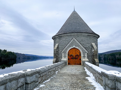
| Description | : | Hartland Hollow was a hamlet in the north east corner of Hartland, CT. It was located in the valley drained by the East Branch of the Farmington River. Starting in 1927, the Metropolitan District Commission (MDC) of Hartford County started buying land in Hartland Hollow and its southern neighbor, Barkhamsted Hollow. The Depression expedited the land acquisition. In 1936 the MDC hired a New Jersey company to strip the land and move both the graves and surviving markers from the cemeteries. In 1937, construction of the Saville Dam began. In 1940, Hartland Hollow held its final annual Halloween... Read More |
frequently asked questions (FAQ):
-
Where is Hartland Hollow Cemetery (Defunct)?
Hartland Hollow Cemetery (Defunct) is located at Hartland, Hartford County ,Connecticut , 06027USA.
-
Hartland Hollow Cemetery (Defunct) cemetery's updated grave count on graveviews.com?
2 memorials
-
Where are the coordinates of the Hartland Hollow Cemetery (Defunct)?
Latitude: 42.0010300
Longitude: -72.9490600
Nearby Cemetories:
1. West Hartland Cemetery
Hartland, Hartford County, USA
Coordinate: 42.0070877, -72.9720917
2. East Hartland Cemetery
Hartland, Hartford County, USA
Coordinate: 41.9993210, -72.9045792
3. Wright Cemetery
Hartland, Hartford County, USA
Coordinate: 41.9744873, -72.8938980
4. South Quarter Cemetery
Tolland Center, Hampden County, USA
Coordinate: 42.0512560, -72.9954010
5. Steadman Cemetery
Tolland Center, Hampden County, USA
Coordinate: 42.0511890, -73.0015190
6. Riverton Cemetery
Barkhamsted, Litchfield County, USA
Coordinate: 41.9600906, -73.0166931
7. Old Riverton Cemetery
Riverton, Litchfield County, USA
Coordinate: 41.9621700, -73.0200200
8. New Colebrook Cemetery
Colebrook, Litchfield County, USA
Coordinate: 41.9838982, -73.0361023
9. West Granville Cemetery
West Granville, Hampden County, USA
Coordinate: 42.0772540, -72.9382700
10. Barkhamsted Center Cemetery
Barkhamsted, Litchfield County, USA
Coordinate: 41.9235992, -72.9655991
11. Poor Farm Cemetery
Granby, Hartford County, USA
Coordinate: 42.0203180, -72.8416990
12. Hemlock Cemetery
Colebrook, Litchfield County, USA
Coordinate: 41.9655991, -73.0492020
13. Merriam Cemetery
North Granby, Hartford County, USA
Coordinate: 42.0181000, -72.8401400
14. Main Road Cemetery
Granville, Hampden County, USA
Coordinate: 42.0699240, -72.8865620
15. Hamilton Cemetery
Tolland Center, Hampden County, USA
Coordinate: 42.0796900, -72.9874600
16. Woodlands Cemetery
Granville, Hampden County, USA
Coordinate: 42.0707920, -72.8835150
17. Silver Street Cemetery
Granville, Hampden County, USA
Coordinate: 42.0527992, -72.8542023
18. Spring Hill Cemetery
Tolland Center, Hampden County, USA
Coordinate: 42.0811100, -72.9964900
19. Burt Hill Cemetery
Tolland Center, Hampden County, USA
Coordinate: 42.0613403, -73.0356369
20. Old North Road Burying Ground
Winsted, Litchfield County, USA
Coordinate: 41.9435997, -73.0456009
21. West Granby Cemetery
Granby, Hartford County, USA
Coordinate: 41.9535522, -72.8400421
22. Riverside Cemetery
Barkhamsted, Litchfield County, USA
Coordinate: 41.9096985, -72.9880981
23. Baptist Cemetery
Granby, Hartford County, USA
Coordinate: 41.9841995, -72.8202972
24. Beech Hill Cemetery
Colebrook, Litchfield County, USA
Coordinate: 42.0165520, -73.0805664