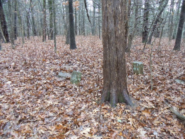
| Memorials | : | 0 |
| Location | : | Boone Township, Franklin County, USA |
| Coordinate | : | 38.3651000, -91.2227100 |
| Description | : | Cemetery rediscovered January 3, 2015. Section 23, Township 42N, Range 3W. Shown on the 1878 Franklin County atlas but heretofore unrecorded. Property owned originally by Spencer Altum, adjacent to property owned by James Heatherly beginning in 1836. James Heatherly was the son of Benjamin Heatherly (see Heatherly Cemetery, New Haven, Franklin County, MO). James R. Heatherly (1806-1887) married Sarah Elizabeth Maupin (1809-1847). The aforementioned dates are from a genealogy on Ancestry.com. James R. Heatherly later married Mary Jane Henderson (see Heatherly Cemetery, Lane County, Oregon). It is probable that James R. Heatherly... Read More |
frequently asked questions (FAQ):
-
Where is Heatherly Cemetery?
Heatherly Cemetery is located at Peters Ford Road Boone Township, Franklin County ,Missouri ,USA.
-
Heatherly Cemetery cemetery's updated grave count on graveviews.com?
0 memorials
-
Where are the coordinates of the Heatherly Cemetery?
Latitude: 38.3651000
Longitude: -91.2227100
Nearby Cemetories:
1. Valentine - Miller Cemetery
Leslie, Franklin County, USA
Coordinate: 38.3729700, -91.2055000
2. Scott-Adams Cemetery
Noser Mill, Franklin County, USA
Coordinate: 38.3678600, -91.1891900
3. Little Creek Cemetery
Leslie, Franklin County, USA
Coordinate: 38.3874300, -91.2409440
4. Antioch Cemetery
Gerald, Franklin County, USA
Coordinate: 38.3757100, -91.2592200
5. Wilson Cemetery
Leslie, Franklin County, USA
Coordinate: 38.3452777, -91.2696761
6. Laubinger Memorial Cemetery
Franklin County, USA
Coordinate: 38.3236008, -91.2146988
7. Martin-Weirich Cemetery
Leslie, Franklin County, USA
Coordinate: 38.3465100, -91.2741600
8. Woodman Cemetery
Leslie, Franklin County, USA
Coordinate: 38.4118996, -91.2352982
9. Gregory Cemetery
Leslie, Franklin County, USA
Coordinate: 38.4035988, -91.2716980
10. Henneke Family Cemetery
Leslie, Franklin County, USA
Coordinate: 38.4206900, -91.2232500
11. Trautwein Cemetery
Champion City, Franklin County, USA
Coordinate: 38.3251000, -91.2722000
12. Leslie United Methodist Cemetery
Leslie, Franklin County, USA
Coordinate: 38.4213430, -91.2238290
13. Seaton Cemetery
Gerald, Franklin County, USA
Coordinate: 38.3940700, -91.2882400
14. Wenkel Cemetery
Champion City, Franklin County, USA
Coordinate: 38.3086535, -91.2526836
15. Giebler Cemetery
Champion City, Franklin County, USA
Coordinate: 38.3118300, -91.2733000
16. Champion City Methodist Cemetery
Champion City, Franklin County, USA
Coordinate: 38.3115880, -91.2830460
17. Saint Johns Lutheran Cemetery
Beaufort, Franklin County, USA
Coordinate: 38.4377060, -91.2025860
18. Danz Family Cemetery
Port Hudson, Franklin County, USA
Coordinate: 38.4381883, -91.2418750
19. Evangelical Saint Paul Cemetery
Gerald, Franklin County, USA
Coordinate: 38.4105988, -91.3106003
20. Dutch Hill Cemetery
Franklin County, USA
Coordinate: 38.2862600, -91.2598300
21. Ficke-McCallister Cemetery
Franklin County, USA
Coordinate: 38.3177986, -91.3118973
22. Koirtyohann-Bates Family Cemetery
Gerald, Franklin County, USA
Coordinate: 38.4286003, -91.2941971
23. New Friendship Baptist Church Cemetery
Gerald, Franklin County, USA
Coordinate: 38.3298790, -91.3275870
24. Lawrence Cemetery
Neier, Franklin County, USA
Coordinate: 38.3358700, -91.1102900

